The high-tech economy begins with local communities. The New Jersey Redevelopment Authority recognized this fact in 2001 by issuing more than $2 million in local planning grants for Cyberdistrict Feasibility studies in 30 communities throughout the state. The purpose of these grants was to identify existing and potential corridors within the state for future high-technology economic development.
Hudson County's 12 municipalities banded together and received one of the largest Cyberdistrict Feasibility planning grants to develop a countywide planning strategy for the digital economy. Hudson County is the most urbanized county in New Jersey and is unique in both its proximity to Manhattan's central business districts and the diversity of its multiethnic population.
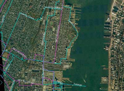
Assessing Hudson County's readiness for the digital economy proved a daunting task. Traditional sources of economic and infrastructure data simply did not reflect the digital reality lurking beneath the county's streets and roads. To draw a more accurate picture of the county's telecommunications infrastructure, planning consultants from Wallace Roberts & Todd, L.L.C. of Philadelphia obtained geospatial data on telecommunications infrastructure from GeoTel Communications, Inc. (www.geo-tel.com) of Orlando, Florida.
GeoTel is a telecommunications research and GIS mapping firm that researches and provides datasets for more than 30 Metropolitan Statistical Areas (MSAs) in the United States and telecommunications data worldwide. An Esri business partner and developer, GeoTel's expertise includes specialists in economic, geography, and telecommunications infrastructure.
Datasets available from GeoTel include multicarrier central business district optical fiber routes; multicarrier Points of Presence (POPs) locations; Internet exchanges (MAEs-NAPS); interconnection facilities such as carrier neutral collocation and data centers; wireless/cell tower locations and owners; and the top 50 carriers' national IP backbones. All of GeoTel's datasets are georeferenced and can be layered on digital street maps, digital elevation models, aerial photography, and three-dimensional imagery.
Anthony Townsend, GeoTel's director of governmental and public affairs, worked closely with Scott Page and other planners from Wallace Roberts & Todd to produce the necessary results for the study utilizing Esri software. According to Page, "We have never had this comprehensive and accurate a picture of local telecommunications infrastructure. The data we obtained from GeoTel had an enormous impact and contributed greatly to our client's improved understanding of its competitive infrastructure assets."