ArcUser Online
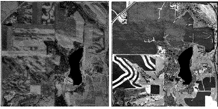
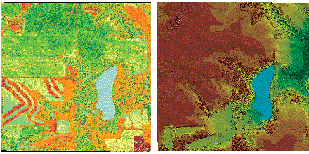
In some cases, it is relatively less expensive, faster, and more accurate than conventional methods of topographic mapping using photogrammetry. In addition, data derived using LIDAR is digital and ready for GIS use. In recent years, federal, state, and local governments have become more familiar with the advantages of this technology and are procuring LIDAR data for land-base development. However, the ability to generate photographic images from LIDAR intensity data is not widely known. Applications that require data showing the most recent changes in terrain can benefit from up-to-date images. For topographic modeling, images or photographs are most often used either to photogrammetrically derive the elevation data or verify data directly collected using active methods such as LIDAR or radar. These images are often used to identify the vegetation and determine bare earth elevation or to verify the overall terrain pattern. Typically, if image acquisition was not part of the project contract, inexpensive and readily available images are used for LIDAR data verification. These images are often significantly outdated and do not show the most recent changes in topography. This problem can be partially resolved by using intensity data captured by most modern LIDAR data acquisition systems while collecting elevation data. The intensity value is a measure of the return signal strength. It measures the peak amplitude of return pulses as they are reflected back from the target to the detector of the LIDAR system. Intensity values are relative rather than absolute and vary with altitude, atmospheric conditions, directional reflectance properties, and the reflectivity of the target. Because these values are relative, the process of creating images from vector intensity data requires the exercise of judgment.
Waggoner Engineering, Inc., of Jackson, Mississippi, was awarded a project that became a test case for this process. The firm, which has been using LIDAR since 1995, was contracted to create a digital terrain model (DTM) suitable for generating two-foot interval contours for approximately 32,640 acres in Goodhue County, Minnesota. The intensity data was acquired as a by-product while collecting elevation data using Optech's (Ontario, Canada) Airborne Laser Terrain Mappers (ALTM) system. Image and intermediate products were created using ArcView 3.2 and the ArcView Image Analysis, ArcView Spatial Analyst, and ArcView 3D Analyst extensions. The benefits of using LIDAR-generated images could be enormous. While creating elevation models, intensity images can be used for LIDAR data verification and can be acquired at no additional cost. LIDAR-generated images can be supplied as an additional deliverable to the clients at only the cost of processing the data. These images could be very useful to clients and substitute for orthophotos to a certain extent. Further research should be conducted by the LIDAR system vendors and users to obtain reproducible intensity values of the features and feature signature values. For more information on using LIDAR data for GIS application, contact Fazlay S. Faruque, GIS Manager |