Introducing the First GIS Enterprise Application Server
 |
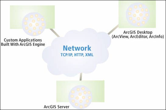
| ArcGIS Server is the first GIS enterprise application server that implements GIS business logic, which was previously available only from GIS desktop solutions, in an IT standards-based server environment. |
A new product available with the release of ArcGIS 9 gives GIS application developers the tools for building and deploying shared server applications that deliver advanced GIS capabilities in Web services and client/server environments. ArcGIS Server is the first GIS enterprise application server that implements GIS business logic, which was previously available only from GIS desktop solutions, in an IT standards-based server environment.
Focused applications created with ArcGIS Server can supply high-level functionality, such as geometric network tracing, linear referencing, geodatabase editing and management, and spatial analysis, to users who are not GIS specialists but who can benefit from GIS capabilities. The proven ability of GIS to enhance operational efficiency and the quality of decision making has been driving the incorporation of GIS into the IT infrastructure.
With ArcGIS Server, existing investments in spatial data can be leveraged through the development of new applications that yield benefits across the organization. Sharing spatial information between and among departments will become as commonplace as the exchange of tabular data is currently and will move GIS into the same enterprise category as enterprise resource planning (ERP) or customer relationship management (CRM) software.
In the next few years, server-centric GIS will complement or provide an alternative to desktop systems. ArcGIS Server represents a significant milestone in Esri's software development strategy. It further integrates GIS within the larger IT environment so that the benefits of spatially enabled information can be shared with a greater number of people at a lower total cost of ownership. With ArcGIS Server, organizations can enjoy the ease of management, scalability, and open platform support of a truly enterprise GIS.
Benefits of Central Management
Centralizing processing capabilities means that software updates are not installed locally on hundreds of individual machines but are made once on the server. Because GIS enterprise application server software can be implemented on standard server hardware, the same hardware and staff can be used to maintain GIS applications along with an organization's non-GIS software. With server-based GIS, adding more users is as simple as upgrading memory, increasing disk space, or adding more ArcGIS Server instances. The load can be shared and balanced between multiple instances with administrative tools that are part of ArcGIS Desktop.
ArcGIS Server illustrates the benefits of Esri's standards-based approach to GIS. ArcGIS Server is designed to run across a single or distributed enterprise system of servers in a heterogeneous environment. It can be implemented using a variety of development environments, commercial application servers, and DBMSs. Support for key standards—Java and .NET for building network enterprise applications and XML (Extensible Markup Language)/SOAP (Simple Object Access Protocol) for messaging and data transfer over HTTP network connections—gives developers great flexibility in communicating with an organization's existing applications and data stores.
A Comprehensive Approach to GIS
ArcGIS Server works with ArcGIS Desktop, ArcSDE, ArcIMS, and ArcGIS Engine. In ArcGIS Desktop, spatial data is created and edited and ArcGIS Server services are managed. ArcSDE manages multiple users editing the same spatial database and supports long transactions, alternate versions, and history. ArcIMS is the solution for Internet geopublishing including high-volume mapping, metadata serving, and data streaming. With ArcGIS Engine, also available with ArcGIS 9, developers can build custom desktop applications that can act as ArcGIS Server clients. ArcObjects provide the underlying architecture for this family of GIS software.
 |
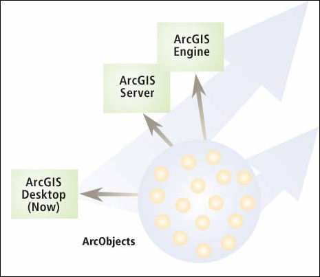
| ArcObjects provides the underlying architecture for ArcGIS Desktop, ArcGIS Server, and ArcGIS Engine. |
ArcObjects are platform neutral software objects that have multiple developer application programming interfaces (APIs) that include COM, .NET, Java, and C++. The ArcGIS 8 Desktop products are built using ArcObjects. With the release of ArcGIS 9, ArcObjects are available in ArcGIS Server and ArcGIS Engine. These two new products give developers a comprehensive GIS development platform for deploying GIS functionality anywhere.
Supplying ArcObjects for both server and desktop application development provides flexibility, interoperability, consistency, and efficiency when building geographic applications across all levels—project, department, or enterprise. With the addition of some rules for programming against the server, experience that a developer has gained in desktop application development using ArcObjects can be applied to programming on the server.
ArcGIS Server adds a framework for running ArcObjects on a server and GIS Web services. Developers can build advanced GIS Web services and Web applications using ArcObjects in standard application server frameworks such as Microsoft .NET and Sun's Java 2 Platform, Enterprise Edition (J2EE).
The ArcGIS Server system is a distributed system composed of four parts—the GIS server, the Web server, Web browsers, and desktop applications. The GIS server hosts and manages server objects, the software objects that supply GIS resources such as maps or locators. The Web server hosts the server applications and Web services written using the ArcGIS Server API. Web browsers let end users connect to Web applications running on a Web server. End users can also connect via HTTP to GIS Web services running on a Web service or over a local area network (LAN).
ArcGIS Server will help organizations benefit from enterprise GIS. Organizations new to GIS will find the ability to furnish distributed, non-GIS specialist users with GIS capabilities coupled with ease of maintenance and scalability, a compelling case for adopting ArcGIS Server. Organizations already taking advantage of GIS will be able to leverage existing systems with this GIS enterprise application server.
Two Esri Press books, Getting to Know ArcObjects—Programming ArcGIS with VBA by Rob Burke and Exploring ArcObjects by Michael Zeiler, are good resources for learning about using ArcObjects. For more information on ArcGIS Server, download the white paper available at www.esri.com/arcgisserver.
|