The Navajo County Public Works Department applied for and received an NACo/Esri grant. The Public Works Department immediately installed the GIS software it received through the grant and put it to use in dealing with the unfortunate catastrophe that was the Rodeo/Chediski Urban Wildland Fire Complex of June 2002. This fire destroyed 462 structures, burned more than 400,000 acres, and required the evacuation of more than 30,000 residents.
Navajo County is located in the northeast corner of Arizona and covers approximately 9,200 square miles. It stretches from Monument Valley and the Utah state border south to the Mogollon Rim and the White Mountain Apache Indian Reservation. The climate and its vegetation vary from dry desert plains in the north to the largest Ponderosa pine forest in the south. The Rodeo/Chediski Fire began in pines on the reservation and spread north into the Apache-Sitgreaves National Forest and into populated areas that included Heber, Linden, and Show Low. From the outset the Navajo County Public Works Department decided to take the lead and offer its services to federal, state, and local authorities. The department was able to estimate the affected population based on census block data. This information was reported to the Navajo County Board of Supervisors for inclusion in a press release.
The department also set up a GIS in the emergency operations center at Holbrook, Arizona, the county seat. GIS personnel tracked the status of parcels so they could learn which buildings were destroyed and which had escaped the fire. This task required dangerous fieldwork and taxed Navajo County's GIS to the utmost.
Fortunately the county's reliable data and fieldwork meant it was able to report, via a hot line, the extent of the fire's damage accurately and quickly to assuage the fears of some residents or confirm the worst fears of others. Because residents of threatened areas had been evacuated, they had to depend on these reports for information on the status of their homes and businesses.
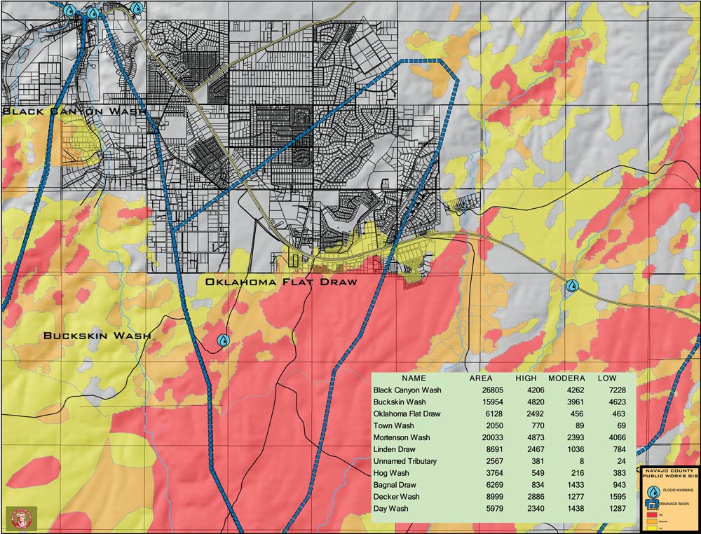
After the fire, the Public Works Department used the data it collected on the intensity of the fire and its effects on the county's watersheds for mitigation efforts. As monsoon season approached, the Public Works Department anticipated that heavy rains would generate enormous water runoffs. After identifying areas of the drainage systems that had been burned more than 50 percent and were located on steep slopes that ran through populated areas, Navajo County used its parcel data to quickly buffer the floodplain and query out at risk addresses. The county could then inform these residents that they might experience higher than normal flows.
At the same time, the Public Works Department placed heavy equipment (such as backhoes and motor graders) and other items (such as sandbags) at strategic locations that were identified by the GIS as being the areas most likely to flood. Stream flows and rainfall were monitored throughout the county and the data incorporated into the GIS. Once a rain event was measured, work began to clear culverts, secure roadways from washout, and place signage to prevent personal injury.
Fortunately, neither the fire nor the flooding injured anyone or claimed a single life. Navajo County Public Works Department believes GIS assisted in making better decisions at critical moments and kept the authorities and the public accurately informed of the impact of this disaster.