ArcUser Online
With the development of a shelter registration application, the emergency management agencies of the City of Oklahoma City, Oklahoma, are more prepared than ever to respond to severe weather conditions. In response to requests from citizens and public safety agencies, the city is using GIS to develop a private storm shelter registration program that ensures public safety agencies will have immediate access to shelter information from any location so residents trapped in shelters can be rescued. The City of Oklahoma City, Oklahoma, covers an area of 622 square miles in the middle of what is commonly referred to as "tornado alley." The frequency and intensity of tornadoes in this area is higher, on average, than other parts of the country. Since 1890, 108 tornados have passed through the city's metropolitan area according to National Weather Service reports. As the city's population continues to increase, so does the likelihood that a severe weather event will affect the property and lives of city residents. On May 3, 1999, a devastating F5 tornado passed through parts of the metropolitan area, causing a large area of damage. [The F-scale rates the damage caused by a tornado on a scale of 0 to 5. F5 tornados are the most devastating.] Emergency management agencies were stretched to the limit as a result of the extent of the damage area. The winds from this tornado were so powerful that whole neighborhoods were damaged to the point of being unrecognizable. In all, more than 6,000 homes, commercial buildings, and other structures were damaged or destroyed. Some citizens were trapped for several hours in underground storm shelters that were covered by debris. With more severe storms threatening the area during that night, rescue personnel searched through debris for trapped victims. Even though the emergency response to the disaster on May 3, 1999, was outstanding, the city realized that information must be more readily available to plan and manage emergency response operations. Additionally, emergency personnel must be able to quickly and easily access the information they need to respond. The city's GIS system was identified as a critical information resource for emergency managers and rescue personnel.
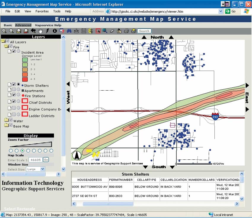
The city's GIS Division of the Information Technology Department began gathering the information requested by emergency managers and developing the mechanisms to deliver the information. The city uses ArcGIS 8.3 with ArcSDE and custom ArcIMS and MapObjects applications running on Windows 2000 Server, Internet Information Services (IIS) 5.1, and Apache Tomcat 4.0.3 server software. As a result of the May 1999 tornado, the city realized that the locations of private storm shelters were needed as part of its tornado response. The city initiated a voluntary private storm shelter registration program to gather the information from citizens. A telephone hot line was established and a Web-based data entry application was developed, utilizing Microsoft's .NET technology. As storm shelter information is entered, the address is matched directly to the address feature class stored in ArcSDE. The city maintains the exact locations of more than 215,000 addresses as a feature class in ArcSDE. The storm shelter data is stored in a Microsoft SQL Server database with a foreign key to the address feature class in ArcSDE. To date, the city has recorded more than 3,000 private storm shelters. An important requirement of the program was to make the information immediately available to emergency managers and rescue personnel. To accomplish this, the storm shelter data is dynamically combined with the address feature class on the ArcSDE server as an SDE view. This storm shelter data view appears as a regular geodatabase feature class to SDE clients including ArcMap and ArcIMS. With the SDE view, the burden of joining the data is placed on the ArcSDE server rather than on the client machine. ArcSDE has proven to be very effective in serving data through SDE views. Because GIS data can be presented as database views, information can be easily served and accessed through ArcIMS browser-based applications. Users with low-end machines and no specialized software can access GIS-based information stored in ArcSDE served in an ArcIMS map service. At the request of public safety agencies, the city's GIS Division has built custom ArcIMS applications. The private storm shelter information is served through ArcIMS map services and is widely available and easily accessible. The map service contains empty datasets that are populated in the event of a tornado or other disaster. On May 8, 2003, after weeks of planning, the city conducted a public relations demonstration of the storm shelter registration hot line to local news agencies. Ironically, less than two hours after the demonstration, an F4 tornado touched down in the city limits. The approximate tornado path was immediately delineated in the GIS system, and 96 private storm shelters were identified as potentially being affected. The information was posted to the ArcIMS map services and hard copies produced for distribution. The ability to access, query, and report this information quickly is dependent on having the latest Esri technology in place. Fortunately, the tornado did not affect heavily populated areas, and no citizens were trapped in storm shelters. Although the area damaged by the May 8 tornado was less destructive, GIS information proved highly valuable for emergency responders. Over the next 24 hours, more than 120 hard-copy maps were produced and distributed. The real test for the system came the following night when a very severe storm passed through the city. However, this F3 tornado did not affect heavily populated areas. Since May 8, 500 additional storm shelters have been registered with the city through the Web site, and another 1,000 have been registered over the phone. The effort to proactively gather and make available information needed by emergency responders proved its worth on May 8 and 9, 2003. GIS has become a critical information resource to emergency managers at the City of Oklahoma City. The city is committed to continuing to expand information availability and accessibility through the latest Esri technologies. For more information on this program, contact Schad Meldrum |