ArcUser Online
Disasters in the form of earthquakes, fires, floods, hurricanes, and tornadoes severely impact communities economically, financially, and socially. Most disasters are characterized by short reaction/response times, overwhelming devastation to infrastructure, and a strain on the tangible and intangible resources of the affected community. Decision makers at local, state, and federal levels are expected to quickly implement plans to restore order and mitigate the aftermath of the disaster. When properly trained, emergency planners and geospatial analysts can take advantage of GIS to aid in tasks such as establishing communications sites, restoring electrical power, and routing emergency supplies to critical facilities. However, in many cases specific datasets will not be available to accommodate every possible contingency that may arise in these operations. The Role of GISFor geospatial analysts, the challenge is to quickly gather data and accurately fuse it together to support emergency planners. ArcGIS is a powerful mechanism available to emergency planners for collecting, storing, analyzing, and sharing the geospatial information needed by agencies to effectively support operations and restore disaster-affected communities in a relatively efficient manner. For emergency planners, GIS can facilitate critical decision making before a disaster strikes and in the crucial early stages of disaster relief operations. Geospatial products can provide important information such as locations of critical facilities (e.g., hospitals, water plants), transportation routes (e.g., major highways, harbor charts), and areas affected by follow-on events such as flooding. These products can be used in every stage of a disaster relief operation, but it is necessary to have an existing GIS, a well-trained analyst, and access to credible data sources.
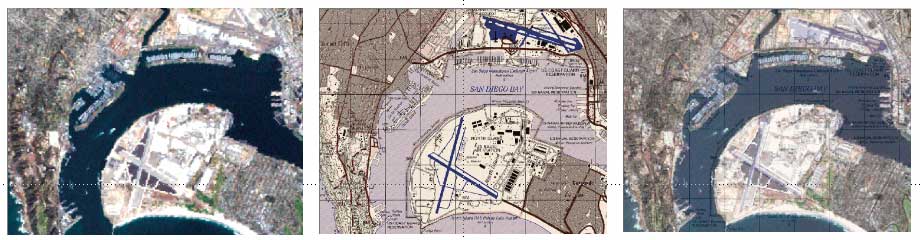
Fusing geospatial products, such as remotely sensed imagery with a digital topographic map, can aid response to a tornado by helping determine tornado destruction paths and allocate debris-clearing resources. Vector data can be fused to this product for network analysis to determine the best route to haul generators from a staging area to power up critical facilities. In addition, this product can be fused later with elevation data derived from Light Detection and Ranging (LIDAR) to identify low-lying areas and create image-based flood maps for postdisaster insurance claims. Geospatial analysts trained for disaster relief operations can provide these types of products to emergency planners before (if possible), during, and after disasters have impacted an area. Requirements for AnalysisTo be able to create products and formulate analysis, it is critical that geospatial analysts
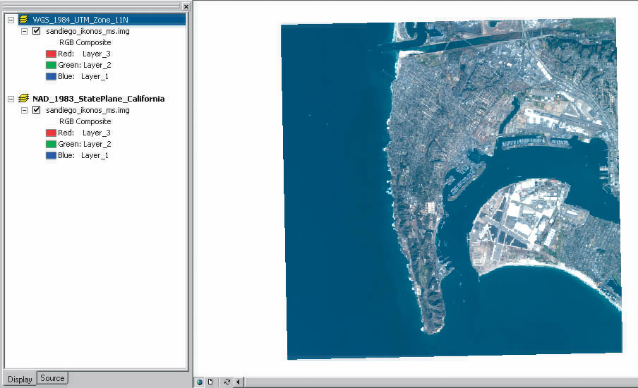
The goal is to develop timely, accurate, and relevant geospatial information that can be easily interpreted by a plethora of end users for a wide range of disaster relief functions. Moreover, the geospatial information must be measurable quantitatively and qualitatively to assure the credibility and integrity of the products produced in support of the disaster relief effort. ArcGIS provides a full range of functionality to disaster relief operations. Providing a common operating picture is critical to the success of any operation, and defining that picture can be problematic when federal, state, and local officials converge on a community stricken by a disaster. According to the Oklahoma Department of Civil Emergency Management, one of the major lessons learned from the 1995 bombing attack on the Alfred P. Murrah Federal Building in Oklahoma City, Oklahoma, was that "a federal, state, and local cooperative partnership is essential for successful response and recovery operations following a catastrophic disaster." Encouraging PartnershipsA successful partnership begins with a common geospatial operating picture that can be established with ArcGIS. ArcMap can supply a common look for geospatial data and, through the use of multiple data frames, display this data in the datums, projections, and coordinate systems that users expect. Local emergency planners in the United States typically use data in North American Datum 1983 (NAD83) and a State Plane projection while initial emergency electrical power responders from the United States Army Corps of Engineer's 249th Engineer Battalion (Prime Power) normally work with the World Geodetic System 1984 (WGS84) datum, the Universal Transverse Mercator (UTM) projection, and the Military Grid Reference System (MGRS). In ArcMap, several data frames can be used to organize one or many layers of geospatial information stacked for analysis within the same geographic extent. This allows geospatial analysts to conduct a wide range of GIS functions on a consistent dataset and provide customer specific datasets in a variety of datums and projections. Locating DataGetting the required data is one of the most crucial aspects of disaster relief GIS. Data mining is arguably the most difficult aspect of the process, because it must be done quickly and the data must be able to support a myriad of geospatial products for emergency personnel and their missions. Often, very large geodatabases need to be processed for what could be just a few related facts. Also, search criteria will often change or be modified depending on the geospatial products required and the stage of the disaster relief operation. Owing to the time constraints of disaster relief operations, geospatial analysts assigned to disaster relief operations should develop a checklist of the data sources needed to support particular disaster relief operations. Table 1 contains a sample predata mining checklist for an earthquake operation.
Continued on page 2 |