ArcUser Online
Does a program for high school students that helps them master high-level GIS analysis tools and techniques while working on real data from their community, solving real world problems, and ultimately joining the geospatial workforce sound impossible? That description fits John Bayerl's GIS class in Dearborn, Michigan. However, getting this innovative program up and running wasn't easy. It required the instructor, students, and administrators to embrace a new approach to education. In September 1995, the Dearborn (Michigan) Public Schools opened the Michael Berry Career Center. This state-of-the-art facility was designed from the beginning to serve juniors and seniors from the district's three traditional high schools and provide them with training for 21st century jobs. When determining the curricula that would be offered, Paul Smith, the director of secondary education, described the mission of teachers at the new center as "training students for jobs that don't exist today."
While traditionally structured hospitality, culinary, medical, and computerized drafting classes were easily moved to the new center, no up-to-date information technology programs were available. Smith saw the potential of GIS to fill this need and brought veteran science teacher John Bayerl on board. Bayerl had completed a master's degree in GIS at Eastern Michigan University and taught an introductory GIS class at the high school level. While Bayerl understood the growing demand for a geospatial workforce, he also realized the monumental challenges of starting such a program. To make the program successful and attract students to the new center, he would have to discard traditional teaching methods and embrace an innovative new approach. This approach should engage students in high-level problem solving and provide them with the knowledge, training, and skills required for a successful career in GIS.
He started with the comprehensive GIS curriculum and certification offered by Esri business partner Digital Quest Inc. (www.digitalquest.com). While many courses claim to be turnkey, this excellent collection of curriculum materials provided Bayerl with everything he needed to teach the course�tutorials, datasets, Microsoft PowerPoint presentations, assessments, projects, lab materials, and lecture notes. Students who complete the course are qualified to sit for the external Spatial Technology and Remote Sensing (STARS) Entry-Level GIS Technician Exam. While Bayerl could have relied completely on these materials, he used them as a starting point to meet his goal of continually challenging students and bringing state-of-the-art software, skills, tools, and experiences into the classroom. This attitude propelled the course from "just another high school computer class" to a cutting-edge, relevant experience that prepares students to enter the high-tech workforce. As a result, Bayerl spent more time adding content to the course than he did actually teaching curriculum materials. Bayerl has used community partnerships, internships, and community service opportunities to challenge his GIS students. Community PartnershipsThe heart and soul of any GIS curriculum is the data available for students to examine. While students can learn to use ArcGIS tools while learning about earthquakes, Florida real estate, or distribution of spotted owls, they are much more likely to apply themselves when using data about their own community. Letting students use familiar data allows them to focus attention on the skills being taught in the lesson without having to learn about the features, setting, or context of unfamiliar topics.
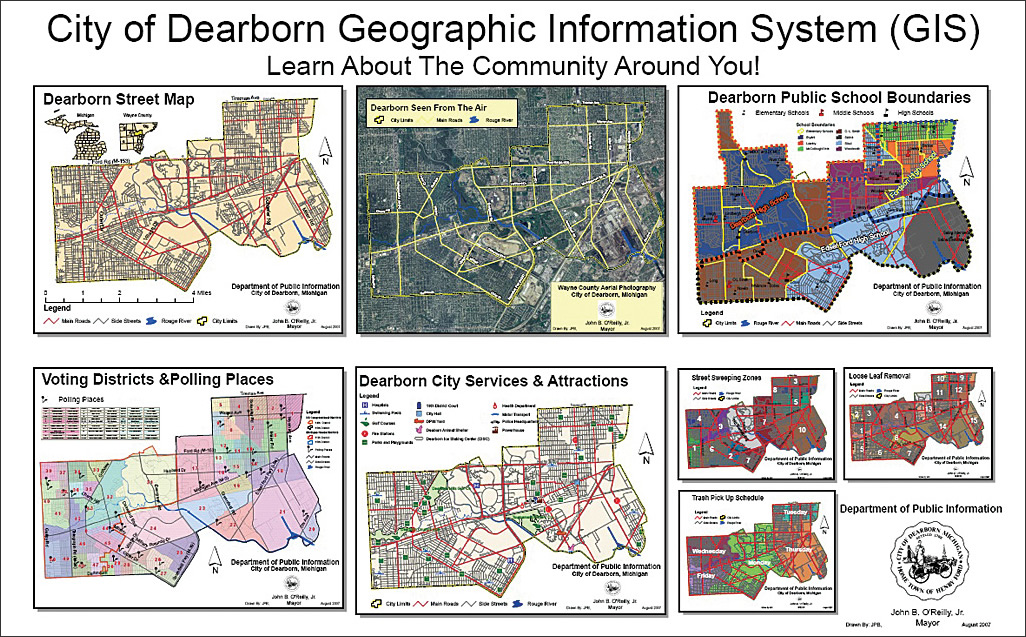
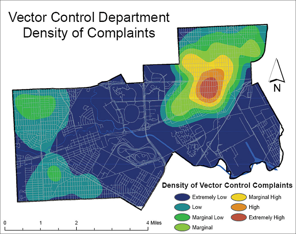
To create such projects, Bayerl reached out to nearby regional, county, and city GIS departments. In the process, he met Sue Katsiyiannis, a kindred soul. Katsiyiannis, GIS supervisor for the City of Dearborn, shared not only a love of GIS but the vision of a future in which GIS formed the framework to access vital civic information that could be used and shared by city government staff, citizens, and schools. To make this dream a reality, Katsiyiannis understood that education was needed to produce knowledgeable technology users. To this end, she shared nearly a terabyte of data that included city shapefiles, digital elevation model (DEM) data, and aerial imagery. In addition, she provided traditional information systems data as tables, databases, and spreadsheets. Students used this data to learn more about their city. Internships and Community Service OpportunitiesGetting students interested in geospatial technologies was just a beginning. To realize the vision of pervasive GIS use, Bayerl and Katsiyiannis had to overcome the fact that nearly no one in the community actually used GIS. Katsiyiannis was the city's GIS department, and Bayerl's five seniors made up one of only three GIS programs in the state. It was a modest beginning (to say the least). What was the solution? Hiring the high school students as GIS interns for the city during the summer helped Katsiyiannis manage, create, and disseminate data. The interns worked on projects designed to demonstrate the value of GIS to various city departments. These projects ranged from exploring the distribution of rats in the city for the Building and Safety Department to using GPS to locate and inspect sewer outflows on the Rouge River for the Public Works Department to mapping underground utilities for the Engineering Department.
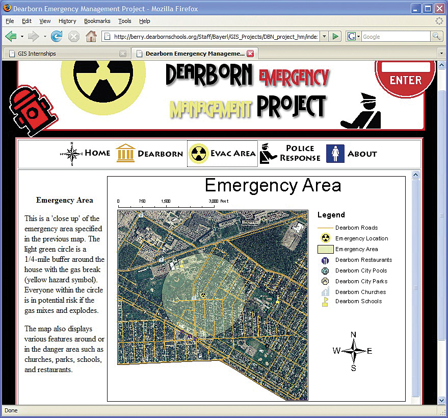
Based on the success of this program, three former interns have been permanently hired by the city and now make up Katsiyiannis' GIS staff. They work as GIS technicians on a part-time basis while pursuing college educations. This success has opened up the possibility of creating more such positions in the future. As the city rapidly moves toward using GIS on a daily basis, the GIS Department is constantly bombarded with requests for data, projects, and maps. The summer internship program will continue for at least the next five years. Each year, it will give three to six high school students the opportunity to work in high-paying, 21st century jobs within their own community. In addition to paid internships, students in Bayerl's class have had a variety of other real-world experiences. Two students gave a presentation at the 2007 Michigan Conference on Career and Technical Education about the program and fielded questions from teachers, administrators, and legislators. Students from the class also attended meetings and training offered by Wayne County Emergency Management and the American Institute of Architects. Next year, students will organize and host a regional student GIS conference. They will invite students from five GIS programs in Michigan and Ohio to share information on their GIS projects and exchange ideas for the future of GIS in the region. Learn about other student achievements at berry.dearbornschools.org/PointsOfPride.htm. The Program's FutureHow have students reacted? Rather than revolt against the increased workload, students have embraced this challenging course and have far exceeded their instructor's wildest expectations. Now entering its fourth year, the GIS program at the Michael Berry Career Center is well established and attracts more students each year. To remain on the cutting edge of information technology curriculum, Bayerl continually adds content to the course to keep students challenged, motivated, and engaged. This year, he added material on using Macromedia Dreamweaver and Flash Web site creation software to his curriculum. Using data from Katsiyiannis, the curriculum materials from Digital Quest, and these new software skills, he had students create Web sites showing how GIS could be used to plan an emergency evacuation, locate a new business in the Downtown Development Authority, and educate neighborhood associations about crime patterns in their neighborhood. These and other Web sites can be viewed at berry.dearbornschools.org/GIS_Internships.htm by clicking the links under 2008 Demonstration Projects. More innovative projects are planned as students learn various other high-tech tools. The Digital Quest curriculum already exposes students to a variety of GIS extensions including ArcGIS Spatial Analyst, ArcGIS Network Analyst, and 3D Analyst as well as software for using remote sensing, CAD, and other data types. Who knows what the future holds? One thing is certain. As new technologies develop, Bayerl will find ways to bring them into his classroom to prepare his students for the jobs of tomorrow. For more information, contact John P. Bayerl at BayerlJ@dearborn.k12.mi.us. |