ArcUser Online
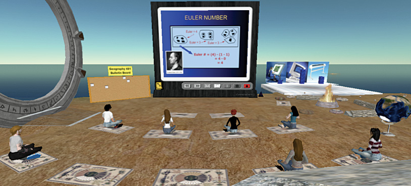
With online delivery of education becoming more prevalent, emerging technologies will have a profound and lasting impact on how GIS courses are taught in the near future. One such technology, the metaverse or digital universe, provides exciting possibilities for building learning communities, enhancing social presence, and creating shared intellectual landscapes than ever before. One such world, called Second Life, is already providing opportunities for in-world discussions, project collaboration, GIS consulting, and even re-creation of real worlds inside the metaverse. Second Life is one of the better-known metaverses and has long been involved both in the development of a social network and the application of its digital environments to education. Both free and paid accounts are available from the Second Life Web site (www.secondlife.com). After obtaining an account, choose an avatar name, download the client software, and enter the brave new digital world. Decide what the avatar will look like. Avatars can be male, female, or even furry. The next stop is Orientation Island to learn how to get around, do commerce, communicate, and even purchase land (with a paid account). New Mexico State University (NMSU) is one of a growing number of universities that have purchased virtual land inside Second Life to use for teaching. At NMSU last semester, some students in the Fundamentals of Geographic Information Systems course joined Second Life and formed study groups on a portion of virtual land called Aggie Island. Every week, they provided a selection of the Microsoft PowerPoint slides from the previous week's lectures that were converted to JPEF files so they could be uploaded to a functional display board on Second Life. These students got together to study every Sunday evening. Because the students were required to respond to the instructor's questions by typing, they not only learned the material but practiced the responses they would eventually use in essay exams. This radically improved these students' test scores. This semester, the GIS students will be using Second Life to collaborate on project-based learning laboratories; visit their instructor during virtual office hours; and, optionally, build three-dimensional models and animations that demonstrate their understanding of GIS concepts and software implementations. The instructor and students belong to a group that provides group chat environments, member lists, and profiles, and their roles (if they have permission to add new members). Former students in the Fundamentals of Geographic Information Systems course have been assigned alumni status and will be paid in virtual money to act as tutors and consultants to the current cohort of students. This allows former students to become part of a larger and ever-expanding learning community. Other institutions are also demonstrating some really clever ways that Second Life can benefit the GIS learner. The University of Texas, Arlington, has created a kiosk for its GIS users to get help with the software and even individual teaching or research applications. The University of Illinois has a site that displays GIS-derived maps of the state for people to examine. There's even a GIS coordinator and part-time instructor from the City of Berkeley, California, who is transforming real lidar data to three-dimensional Second Life objects called sculpties. These models allow people to view real-world topographic features up close in Second Life.
These objects can be made large enough to re-create real environments so students working on GIS projects, through the use of their avatars, can actually experience the environments they are modeling with GIS. Imagine, for example, being able to use virtual worlds to experiment with real-world modeling scenarios, do ground truthing, and even collect data on locations of individual avatars using the in-world maps that are available in Second Life. The possibilities for using Second Life for GIS and spatial analysis education are nearly limitless. Much like GIS itself, these applications are limited only by the creativity of the user (apologies to Jack Dangermond for paraphrasing). Metaverses are the future of education as well as commerce. Corporations that have presence in Second Life include Coca Cola, IBM, and SONY. Other organizations—publishers, such as John Wiley and Sons, Inc.; federal agencies, such as the National Oceanic and Atmospheric Administration (NOAA) and National Aeronautics and Space Administration (NASA); and government bodies, such as the United States Congress—exist in Second Life and often conduct real business. There are groups of educators who are getting together to explore how Second Life can be used for learning. The Educator's Coop from the University of Texas (educatorscoop.org/) and Technology Enhanced Learning and Research (telr.osu.edu/) at The Ohio State University are two examples of these groups. Even Linden Laboratories, the creator of Second Life, has developed forums for sharing ideas about the myriad possibilities for using Second Life for learning (www.sl-educationblog.org/). The possibilities of using this content-rich environment for GIS education are exploding. For more information, contact Dr. Michael N. DeMers |