ArcUser Online
For Boone County, Kentucky, the solution came through using the ArcGIS Data Interoperability extension, which provides powerful spatial ETL (extract, transform, and load) capabilities. The use of this extension spared Boone County the nightmare of manually consolidating information from many different agencies into a single usable dataset that could be shared by all its clients. Production and Publication DataBoone County GIS is a consortium of 30 agencies with more than 700 users in Boone County and northern Kentucky. Like most IT departments with volumes of data stored in disparate formats and data schemas, getting functional data into the hands of end users was an issue. Boone County's data environment is divided between production and publication data. Production data is actively edited. Published data has been refined into information that is easily consumed by end users. Boone County's objective was to design a single production data model with a schema that was flexible enough to support the data transformation requirements necessary to pull many different data models—created using various schemas—together. The county's published data is available to the public via its ArcIMS and ArcGIS Server Internet mapping Web site (www.boonecountygis.com) and its own users via a custom built ArcReader/C# application called BooneMap. Consolidating Data for End UsersSpatial ETL tools can extract data from the source (production) data model, transform the attributes and geometry of the source data to match the destination (publication) data model, and load the transformed data. Many people think the ArcGIS Data Interoperability extension is limited to converting Esri formats into other software formats and vice versa, but this is just one of many modifications that can be made during the conversion process. Since Boone County's data was already being maintained in Esri formats, conversion between formats was not part of the overall data migration process. Instead, Boone County wanted a solution that would enable the easy manipulation of production data in a variety of ways to generate value-added published data for end users. "Essentially, we wanted to perform as much of the �heavy lifting' on the back end as possible by preprocessing the data into something a bit more user friendly," said Steve Gay, the GIS coordinator for Boone County. "Early on, we knew the different ways that we wanted to transform the data, but we thought that in order to achieve this, we would have to invest heavily in a lot of complicated programming. We were desperately seeking a solution that was easy to use and would ultimately enable us to republish our data at a moment's notice."
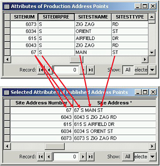
After seeing a presentation by Esri's Steve Gris� at the 2005 Esri User Conference, Gay approached Gris� with his predicament. To his delight, Gris� explained that the ArcGIS Data Interoperability extension would be able to accommodate the data transfer needs of his department and manage the transformation of data from the production environment to the publishing environment with no complicated manual programming. Boone County purchased the ArcGIS Data Interoperability extension and began using FME Workbench, a graphic authoring environment included with the extension that provides more than 200 transformers for manipulating geometric and attribute data. Because the visual interface was easy to use and required no code writing, Boone County staff quickly became proficient in building data transformation workflows. Data transformations authored using the Workbench application are saved as geoprocessing tools or models inside ArcToolbox. Accommodating Many SchemasGay uses the term "atomic attribution" to refer to the data modeling strategy of storing attributes in their lowest possible components, then combining these values together when needed. "It's much easier to combine separate values together than it is to try and parse a single value into its component parts," said Gay. This strategy provides flexibility by allowing the data publisher the freedom to choose the field values that need to be concatenated. "Everyone today seems to have their own schema requirements. By employing atomic attribution, we have the capability to provide our data to all of our usual data recipients according to their data formatting requirements," Gay added. Boone County currently uses 243 domain tables to support 142 feature classes in its ArcSDE production geodatabase. Conversely, the ArcSDE publishing geodatabase serves 162 feature classes that use no domain tables. Various steps had to be taken during the transformation to accurately map the data sources in the production geodatabase to a single publication data model. The Data Interoperability extension, and specifically the Workbench application, was used to build reusable spatial ETL tools that accurately and efficiently generate publication datasets. These tools are used to work with domain tables, map field attributes, and perform spatial conflation. Working with Domain Tables and ValuesWhen Boone County publishes its data, any field that uses a domain table gets the domain table's coded value converted to its corresponding descriptive value. ValueMapper, one of the transformers furnished by the Data Interoperability extension, accomplishes this task. "Users have an easier time understanding the data when they don't have to constantly stop and determine what a coded value represents," said Gay. "We make it explicitly clear by providing them with the textual description rather than some obscure code that may or may not mean something to the end user." In some cases, the domain table's coded values and description are exported into two separate fields. "Even though most users prefer the spelled out description, there may be an additional need to preserve the coded value in the published data for labeling purposes. The Data Interoperability extension allows us to export whatever we want—the code, the description, or both if necessary," Gay continued. Attribute Field MappingA simple example of field mapping combines multiple fields from the source data into a single field in the destination geodatabase. Using several different transformers provided by the Data Interoperability extension, GIS staff at Boone County can easily concatenate field values. Boone County publishes the address number by itself in its own field as well as in another field combined with all other address components in data published by its own users. "Doing this allows the end user to decide if they want to label a location with its full address or just the address number if they're trying to make the map less busy," explained Gay. Because the address number for both fields originates from the same value in the production data, there is never a risk that the two published fields will contain conflicting address numbers. Spatial Conflation
Publication data can also be generated by populating new datasets with information derived from spatial relationships stored in the production data. Boone County had a somewhat unique need to transfer some address information from the Address point layer onto two polygon layers—Buildings and Parcels. The Data Interoperability Point-On-Area Overlayer transformer performs a spatial join between two layers. Since Boone County's business rules dictated that (1) address points should be located on top of the associated building polygon feature and (2) all parcels must contain an address point, the Point-On-Area Overlayer transformer could be used to enter address attributes from the production address points into published building and parcel polygons by spatially joining the layers. The same Point-On-Area Overlayer transformer was also used to compare every address point's location to 19 different polygon layers. To help visualize this, Gay used this analogy, "Think of overlaying all of your large-scale administrative boundary polygon layers, such as fire district, voting precincts, and census blocks, and then hammering a nail through them all at the same location." This process transfers information relevant to each address from the intersected polygon features to the published address points. Boone County adds this spatially related information to its published address points to enable end users to focus much of their query efforts on the address points. "This methodology empowers our users by providing them with the ability to perform multicriteria attribute queries on one layer and generate an address list tailored to their needs," added Gay. This process also explains the discrepancy in the number of feature classes between Boone County's production geodatabase (142 feature classes) and its publishing geodatabase (162 feature classes). The additional published feature classes contain features that do not have to be actively maintained (and therefore don't exist in the production geodatabase). Instead, these features are derived by running geoprocessing operations on features from other feature classes. Boone County has automated this creation process with the Data Interoperability models. These models facilitate periodic updates of feature classes. A perfect example of this are the polygon layers created from buffering certain features. "We publish several polygon layers that are essentially buffers of other point or polygon features," said Gay. "As these source features change, the associated buffers may need to be updated as well." Instead of maintaining these buffer areas in their own layer, Boone County re-creates the layer's geometry and attributes using Data Interoperability models. Gay points out that this not only frees up staff time but also provides an easily repeatable and documentable method of creating layers. ConclusionAs Boone County demonstrates, the ArcGIS Data Interoperability extension is more than a way to convert data between Esri formats and other formats. It greatly facilitates the manipulation of data in the production environment, increases the quality of published information, and improves customer service. In the process, Boone County set a precedent by creating a new model for managing address points—one that speeds the production-to-publication process without complicated programming or additional resources. |