ArcUser Online
A parcel rezoned for residential use, even if not immediately developed, will probably be an area of future development. This analysis assumes that properties rezoned as residential, which have not been subdivided or platted, will be developed in the near future. Using ArcGIS, the project's goal was to predict the infrastructure needs caused by that development. Coping with GrowthThe need to identify future development spatially has always existed, but it has been acutely felt in Forsyth County. As the fastest-growing county in Georgia and fourth fastest-growing county in the United States (based on U.S. Census percent change figures for 2006�2007), the demands on the county's infrastructure have been increasing. In addition, worsening drought conditions across the southeast prevailed at the time of the study. The demands on the county's infrastructure were higher than ever. To cope with this demand, county commissioners approved a moratorium on rezoning for residential development. Commissioners asked the county's staff to survey existing infrastructure capacity and analyze whether this capacity would meet projected growth demands for public facilities such as roads, sewer, and water. As part of this survey, the number of potential housing units and residents, both countywide and for each sewer basin district, would be projected. With the help of ArcGIS and the large amount of GIS data the county was maintaining, in-depth spatial analysis on the current status was possible and successfully performed. What Was Included in the StudyAll residentially zoned parcels over a specific size were selected for the study. This excluded smaller parcels that are unlikely to be subdivided from the build-out. This analysis used two thresholds—5 and 10 acres. Of the parcels that met the threshold size, parcels in the rezoning application boundaries were selected because they were more likely to be developed in the near future. Using these parcels also helped the analysis reach more realistic conclusions.
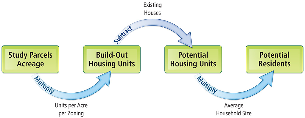
Parcels located in existing subdivisions were also removed from the study because these parcels, bigger than the subdivision's lot size, would be unlikely to be developed. Also, any golf courses and Park/Recreation/Conservation (PRC) areas in existing subdivisions were excluded. The environmental/development limitation areas were summed and clipped out from the study area using the Erase tool in the Overlay toolset of the Analysis Tools in ArcToolbox. Floodplain, wetlands, stream buffers, lakes, parks, and school properties were also excluded from the analysis. The sewer basin attribute table was joined to each study parcel using the Identify tool in the Overlay toolset. The study parcel layer dissolved by zoning category for each sewer basin using the Dissolve tool in the Generalization toolset of the Data Management tools to get the size in acres for each zoning area in each sewer basin. Calculating Potential Housing Units and ResidentsAfter calculating the acreage of the study parcels for each zoning category and sewer basin, the acreage was reduced by 15 percent to represent the amount of land typically required for infrastructure such as roads. Next, the units per acre were determined for each zoning category. Build-out housing units were calculated by multiplying units per acre for that zoning category by the acreage in each zoning category. To make the results more accurate, the number of structure address points in study parcels was calculated for each zoning category and sewer basin using the Spatial Selection tool and subtracted from the build-out housing units to generate the number of potential housing units. Finally, multiplying the average household size, based on the most recent U.S. Census data, yielded the number of potential residents. Results and Conclusion
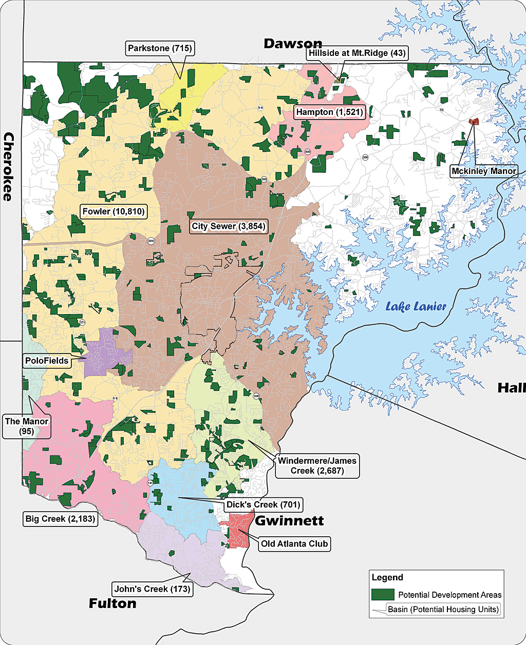
The number of housing units and residents was calculated for each sewer basin using ArcGIS. A map showing the final results was presented to the county commissioners and public as part of the infrastructure survey. The map helped local officers find out how much and where future development would occur so they could plan for necessary infrastructure expansions. The whole process was built in ArcGIS ModelBuilder and can be repeated using the updated GIS data. Because the final projection number could be calculated by any subdistrict—not just by water/sewer basins—it can help any department project future infrastructure demands spatially. This analysis could also help planners identify how many rezoning applications were approved and waiting to be developed and help control upcoming rezoning activities. For more information, contact Jihoon Son at json@forsythco.com. AcknowledgmentsSpecial thanks to Tom Brown, assistant director of the Planning Department; Jeff Chance, director of the Planning Department; and John Kilgore, director of the GIS Services Department of Forsyth County, Georgia, for their ideas and support. This article was made possible by their contributions. About the AuthorJihoon Son is a GIS specialist for the GIS Services Department of Forsyth County, Georgia. He received his master's degree in city and regional planning from Georgia Institute of Technology and is a member of the American Institute of Certified Planners. Learn MoreEsri offers an instructor-led course, Advanced Analysis with ArcGIS. |