ArcUser Online
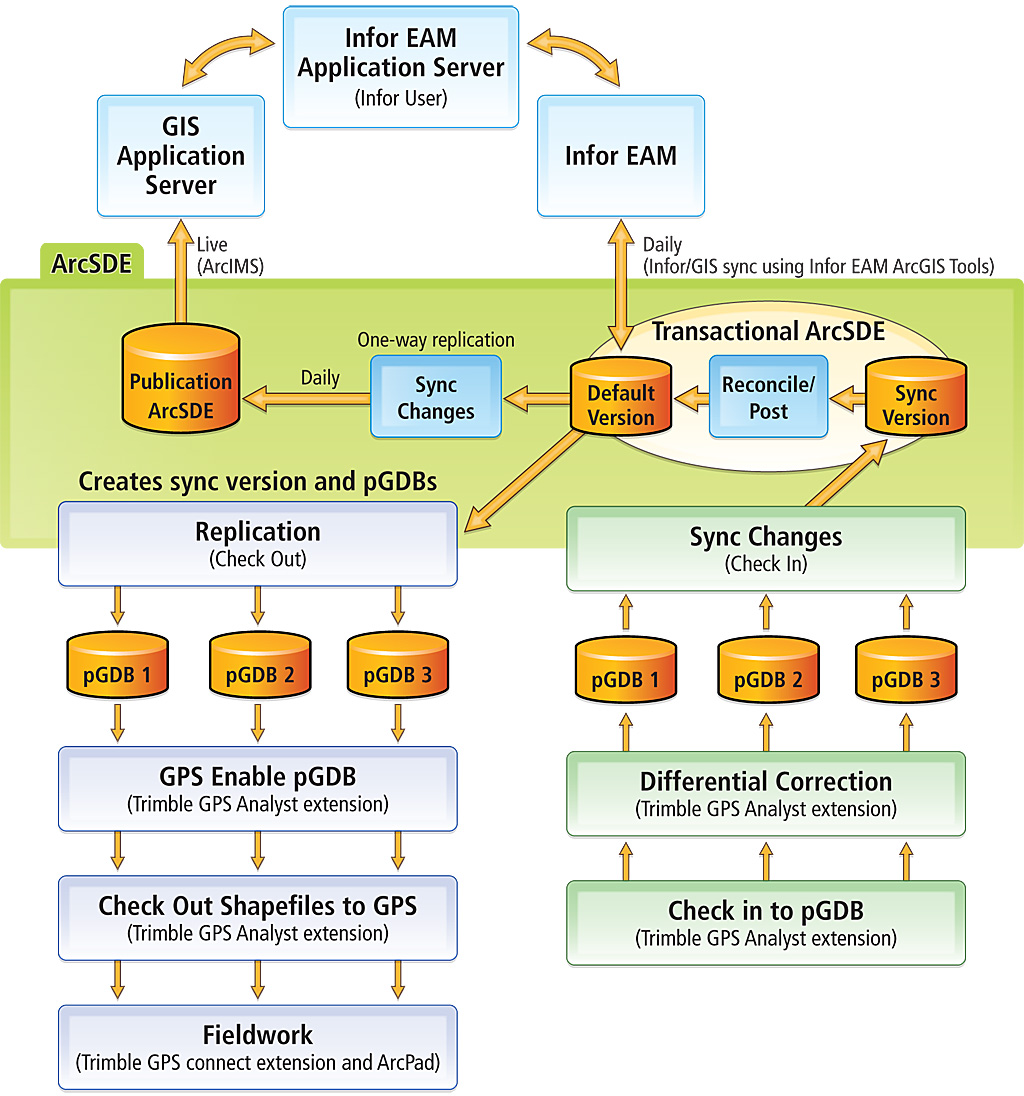
The Department of Transportation (DOT) uses the Infor EAM (Enterprise Asset Management) system to manage work orders for all street, sign, and other right-of-way (ROW) assets such as street trees. In partnership with the Department of General Services and the Information Technology Department Central GIS team, DOT has implemented the GIS module of Infor EAM to more effectively manage street sign assets in the city. The EAM DOT implementation is the first in the department to fully implement a solution that collects and manages assets using Infor EAM integration tools to synchronize GIS data with the Infor EAM work order management system. Meeting a Business NeedThe city wants to reduce the number of redundant enterprise information systems that collect and manage information. Efficient information collection, management, and integration with business systems—with as little customization as possible—is a high priority. The Department of Transportation has been using the Infor EAM system to manage work orders against assets for several years. However, efficiently scheduling and dispatching work is difficult to manage without having the spatial location information associated with assets. The Traffic Signs and Markings Division approached the Central GIS Unit to design and implement a GIS solution to collect street sign assets, manage spatial and attribute changes to existing assets, and integrate GIS information into the Infor EAM work order management system. The Central GIS Unit devised a business workflow that allowed the Traffic Signs and Marking Division to create new traffic sign assets while updating existing sign asset locations, attributes, and work orders. Figure 1 provides an overview of this process. Business Workflow DevelopmentThe Central GIS Unit met with the Traffic Signs and Markings Division and Infor to map out the business workflow that would inventory and maintain the traffic sign database that manages spatial edits in ArcSDE and work order management in Infor EAM. During the business workflow development phase, it was determined that a field data collection component was needed. The Central GIS Unit recommended the division use the Trimble GPS (GeoXT) unit that the division had already purchased. The business development team identified the specific spatial features and attributes that needed to be collected in the field. In addition, traffic sign supervisors were identified as the staff members who would use the GPS unit for creating the new assets when notification to Underground Service Alert (USA) teams was required. The need for a GIS data manager role was also identified. The GIS data manager would update and maintain existing sign assets, coordinate the field data collection activities of the supervisors, and postprocess and integrate field data into the ArcSDE transaction and the Infor EAM databases. Data Collection, ArcSDE Synchronization, and Work Order Management Systems Integration
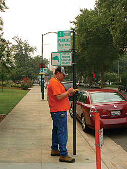
The Central GIS Unit started testing field data collection procedures and ArcSDE update and synchronization procedures once the business development phase was completed. The Traffic Signs and Markings Division had already decided to use Trimble GPS units because this group already used the unit for other basic field data collection tasks. The Central GIS Unit recommended using a noncustomized ArcPad application, Trimble GPScorrect extension for Esri's ArcPad, and the Trimble GPS Analyst extension for ArcGIS Desktop for collecting, correcting, and processing field data using GPS. Standardized attribute domains were developed and incorporated in pick lists in the ArcPad application running on the GeoXT units. Because these products function seamlessly with ArcSDE and personal geodatabases and require no customization, the division was able to keep down the cost of hardware and software and alleviate the need for creating and maintaining a custom ArcPad application. This helped streamline data integration to/from the ArcSDE transactional database. During the business workflow phase, the Traffic Signs and Markings Division decided three or four field people would be needed to collect and update the sign inventory. ArcSDE checkout replicas were developed to generate individual personal geodatabases for each GPS unit so sign data could be checked out to each field-worker. This would take advantage of the GPS Analyst extension's ability to check data out as shapefiles for update in the field, then check new and updated features and GPS positions back into the geodatabase as well as perform postprocessing differential correction on the field data while in ArcGIS. An ArcSDE one-way replication process was developed to create the communication link between the transaction and publication ArcSDE databases. A simple Python script was created that uses a Windows scheduled batch process to perform the data transfer between the transaction and publication environments on a nightly basis, during off-hours. The Central GIS Unit also developed back-end processes to use the Infor EAM ArcGIS toolbar to synchronize the transaction ArcSDE with the Infor EAM database. This synchronization occurs prior to the nightly automated synchronization. Business Systems Integration TestingOnce the field data collection, ArcSDE, and Infor EAM integration processes were developed, the full sign inventory workflow needed to be tested before implementing the GIS and work order management integration processes in a production system. The Central GIS Unit maintains both a development and production set of ArcSDE servers and software. The Central GIS Unit and Infor EAM business teams follow standard information technology testing and implementation practices that involve coordination with other information technology staff, database administrators, and other GIS analysts and their respective projects.
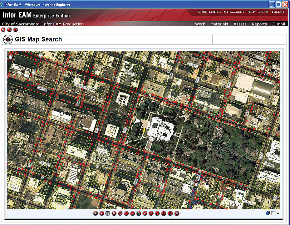
The workflow described above was fully tested in the city's development ArcSDE and Infor EAM environment to ensure that field data collection processes, data check-in/checkout procedures, and ArcSDE and Infor EAM synchronizations were functioning properly. Once the integration team members were satisfied with the workflow and performance functions, the sign inventory workflow was transferred to production ArcSDE and Infor EAM systems. Production ImplementationAfter all of the GIS and work order management systems were thoroughly tested for managing and updating data, the traffic sign inventory was put into production. In this phase, the production transactional and publication ArcSDE, GIS application, and Infor EAM work order management environments were used. Replication, synchronization, and back-end scripting processes were modified to point to production data. In the first nine months of the sign inventory, the Traffic Signs and Markings Division staff of four field-workers collected nearly 10,000 street sign assets (e.g., signs, crash attenuators, parking meters, barricades, and guardrails). Post Implementation DiscoveriesActual field data collection began in November 2007. The initial sign inventory was conducted in downtown Sacramento, an area with many tall buildings and large trees that delay the acquisition of a quality GPS signal when locating an asset. After a short time, the primary GIS data manager decoded that inventorying existing signs was more efficiently accomplished using Panasonic Toughbook Tablet PC loaded with ArcPad and the city's high-resolution (6-inch) digital orthophotography, street centerlines, parcels, and Master Address Database rather than GPS units with ArcPad. Based on visual information and infrastructure data layers, field-workers could quickly and accurately locate the sign assets without using GPS. The data manager continued dispatching workers with Trimble GPS, ArcPad, high-resolution imagery, and infrastructure GIS files to parts of the city that did not have tall buildings or large trees. The combination of data collection methods has proved beneficial. Future Integration ProjectsWith the success of GIS asset collection, the Traffic Signs and Markings Division is investigating the possibility of integrating digital photos of signs with sign location information. Although digital image collection was originally proposed as part of the data collection process, it was postponed to a future phase of the sign inventory. In addition, the city is applying the knowledge and skills gained from the street sign inventory to other citywide asset management projects. The city will be developing an inventory for all city-owned trees that will be managed by city staff using the methods developed for signs. The city is also working with the Parking Division to inventory parking meters using geocoding processes for the initial placement of parking meters and field data collection methods for on-going data maintenance. Traffic Signs and Markings, Urban Forest Services, and the Parking Division—all part of the Department of Transportation—use the Infor EAM work order management system. The asset inventory methods and protocols developed for street signs are helping build efficiencies and streamline asset data collection, management, data update, and field crew dispatch and more effectively perform labor and expense tracking. This was accomplished without custom field data collection methods or software. The current ArcSDE implementation is running on Oracle, the standard configuration for the Infor EAM work order management software; uses ArcGIS toolset; and regularly manages GIS base data (e.g., streets, parcels, addresses, and orthophotography). For more information, contact Nathan Jennings, senior GIS analyst for the City of Sacramento, Central GIS Unit, Information Technology Department, at njennings@cityofsacramento.org. AcknowledgmentsThe author thanks staff of the City of Greensborough, South Carolina, for sharing knowledge of Infor EAM and the use of GPS for collecting assets. Tom Webber, operations general supervisor for Traffic Signs and Markings, Department of Transportation, City of Sacramento, provided information on the division's business needs. Daniel Choe, business analyst for the City of Sacramento, Department of General Services, supplied internal knowledge of Infor EAM, and Bill King, formerly with Infor, assisted the City of Sacramento in developing the Infor workflows for the street sign asset inventory. Ken Chapman, traffic worker for the City of Sacramento, Street Signs and Markings, Department of Transportation, and Maria MacGunigal, GIS manager for the City of Sacramento Central GIS Unit of the Information Technology Department, contributed to this article. |