ArcUser Online
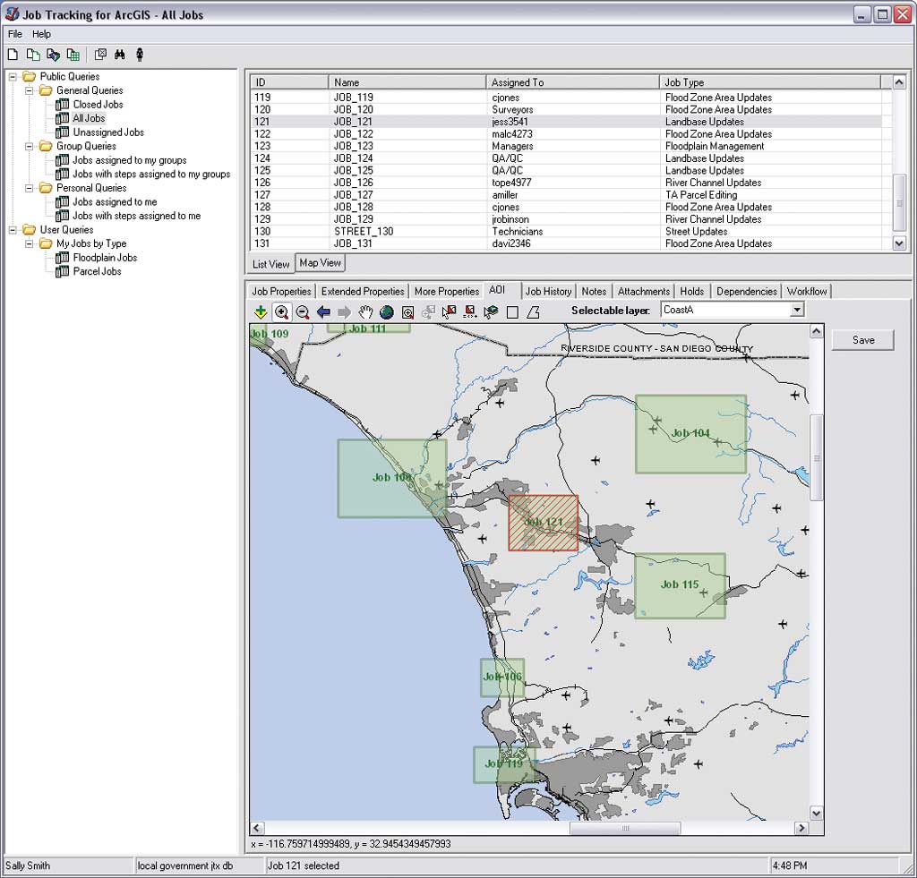
What is a workflow? It is "a way to make people, information, and computers work together consistently and efficiently to produce the results the business needs," according to Rick Cook in an article in CIO magazine entitled "Making Workflow Work and Flow for You." This definition could be expanded to include not just businesses but also agencies of local, state, and federal government and other organizations that have business needs and clients to please. A workflow is a stream of related activities that accomplish a specific goal. That goal could be placing an order or filling a pothole. The Value of WorkflowsEffective workflows can hide complexity from users, minimize mistakes, and enhance the responsiveness of an organization to customer requests. Because workflows are repeatable processes that save money and time, good candidates for workflow optimization are activities that are well structured and not too flexible. Esri has always promoted data sharing and embraced IT data and interoperability standards, which has enabled organizations to integrate GIS with other business systems. Taken together, these developments have fostered the adoption of GIS throughout organizations and its incorporation into organizational workflows. Esri software supports workflows in many ways: through GIS server-based workflows, tools and models, and specific solutions such as the Job Tracking for ArcGIS (JTX) extension for both ArcGIS Desktop and ArcGIS Server. ArcGIS Server technology supports both geocentric and geospatially enabled organizational workflows. In geocentric workflows, GIS provides a foundation for business processes and is essential in achieving business objectives. Land records systems, transportation systems, forestry management applications, and risk analysis applications are all examples of geocentric workflows. The development of GIS servers supports this kind of workflow by providing a mechanism for sharing geospatial applications and services throughout the organization. For instance, in a transportation system workflow, multimodal models developed by an engineer with expertise in transportation GIS applications can be published and used by other staff members or consumed by other applications. GIS is also important to traditional business workflows. Geospatially enabled workflows for activities such as business intelligence, supply chain management, or customer relationship management help organizations realize gains in efficiency, accuracy, or other quality metrics. In these situations, end users who employ custom applications created with ArcGIS Engine or ArcGIS Server to accomplish everyday tasks may not realize they are using GIS techniques and processes. For GIS professionals, ArcGIS handles many previously onerous aspects of data management and much of the complexity of geospatial operations. The result has been that GIS users can accomplish a lot in a few steps. Processes, particularly rote geoprocessing tasks, can be standardized and automated. ArcToolbox contains hundreds of tools that can be run individually, run in batch mode, or incorporated into a ModelBuilder model. These tools are written in Python and can be customized using this powerful and popular scripting language. Models are especially useful in developing effective workflows. Models can be developed as a mechanism for solving specific problems or as generic tools that can be shared with coworkers. JTX, an ArcGIS extension, provides a workflow system for GIS applications, such as mapping, spatial analysis, and data management, by organizing GIS tasks for projects that will be completed systematically by a group of people. JTX works by breaking down a GIS job into a sequence of tasks (e.g., compile data, digitize, update, perform QA/QC, design a map) using a graphic diagramming tool. Each task and the data and software used to accomplish it are defined and assigned to the individual who performs the task for a specific geography. Applying WorkflowsWorkflows in GIS are getting simpler. ArcGIS provides support across desktop, server, mobile, and Web platforms with tools that streamline processes, and it encourages collaboration. However, creating powerful, useful workflows no longer requires hiring the expertise of a consultant or maintaining an extensive custom code base. Articles in the Focus section of this issue illustrate this new reality. How does a GIS department in Kentucky convert production data from 30 participating agencies into a single data model that is easily published and consumed by the public via value-added products? Boone County simply employs the ArcGIS Data Interoperability extension to manipulate source data that is supplied in numerous schemas. Using the graphical authoring environment of an application that comes with the ArcGIS Data Interoperability extension called FME Workbench, staff members have developed transformation workflows that model data in a format that stores attributes in their lowest possible components and concatenates them on demand. ArcGIS supports workflows that span mobile, desktop, server, and Web platforms so the entire organization can benefit from sharing data. Ottawa County, Michigan, law enforcement staff enhanced emergency response and public safety by taking advantage of this strength. The sheriff's office created an ArcGIS Server application that lets sheriff's office staff who have limited experience with GIS view the previous day's 911 calls spatially using a Web browser. The county's computer-aided dispatch (CAD) program supplies incident data for the application. Using a Python script, CAD data is converted, scrubbed, and geocoded in a single operation that is performed on a daily basis. Staff members can view this data by more than 100 incident types and venues, export incidents to a Microsoft Excel spreadsheet, or select incidents using a buffer. Calls can also be cross-referenced by patrol zones, municipal unit, day, time period, or incident code. Because of its broad functionality and ease of use, Ottawa County's Incident Mapping tool has become part of the workflow of many units in the sheriff's office. For example, the investigative unit conducts both respective and prospective analyses and identifies patterns of crime using the Incident Mapping tool. It is also employed as an educational tool and aids in community relations. Making current, valuable data available across the organization is also one of the key benefits of a GIS workflow instituted by the City of Seattle, Washington. The city's Central GIS Unit worked with the Traffic and Signs and Markings Division to develop a business workflow that efficiently inventories street sign assets and maintains the traffic sign database. This workflow promotes reuse of data across the organization while reducing the number of redundant enterprise information systems used for collecting and managing information—all with minimal customization of GIS software. When the system was put into production, four field-workers collected location and condition information on nearly 10,000 street sign assets. Designed for ProductivityArcGIS supports workflows that empower users at all levels and helps them become more productive. As the articles in this issue demonstrate, it is not necessary to be a developer to create powerful, useful workflows. By linking geoprocessing tools in a sequence of operations using ModelBuilder models and scripts, tasks can be automated on the desktop or server. Workflows developed with ArcGIS have decreased the overhead associated with implementing and growing a GIS while promoting improved data handling and dissemination. Hear from Users2008 Special Achievement in GIS Award�Reliance Energy Limited Implements Esri GIS to Leverage Spatial Information Across Diverse IT Network
|