ArcUser Online
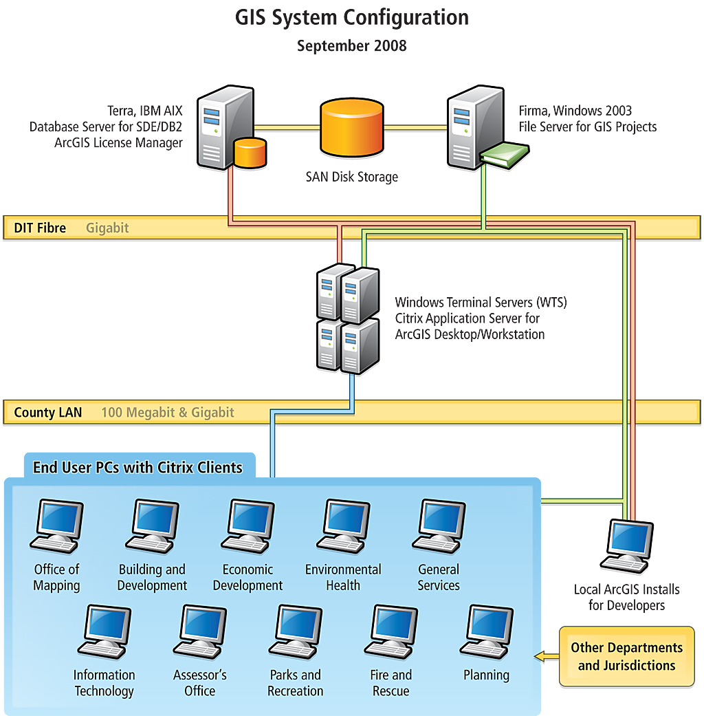
The county was an early adopter of GIS and has used Esri products since 1986, developing processes to map property boundaries and assign addresses. Its GIS currently has more than 150 data layers and supports a wide range of internal users through ArcGIS Desktop products and intranet applications as well as hosting an Internet mapping site. ArcGIS Desktop is served through Citrix application servers while the database is managed using ArcSDE running on an IBM AIX server with DB2 as the underlying relational database. Since DB2 is the county mainframe standard, spatial data can be used in a variety of ways in conjunction with other county databases and systems including computer-aided dispatch (CAD) and permitting. Past GIS Use: A Laborious Manual ProcessThe CAMA system used in Loudoun County is a mainframe system designed in the 1980s. It lacks functionality and requires a great deal of knowledge and expertise to manipulate the data from the CAMA system and link it to the GIS parcel layer. The Assessor's Office does not have dedicated mapping staff, so staff appraisers must work with the GIS staff to map any detailed assessment data. Appraisers download assessment data to spreadsheets that are given to the GIS staff. These spreadsheets are joined to tables in the county's GIS so assessment data can be mapped. This time-consuming process was required even when an appraiser simply needed to review data and didn't need a printed map. Alternatively, appraisers could view data using WebLogis (www.loudoun.gov), the public mapping program created by the GIS staff using ArcIMS to view GIS data. Appraisers must view their data in a separate window and the program does not include data needed by the appraisers, such as values, structure type, sales, improvement square footage, and year built. Appraisers must first use the parcel identification number (PIN) search to locate the parcel. Once the parcel is found, clicking the See Assessment button shows parcel ownership, structure information, recent sales, and tax history information for that parcel from the Real Estate Tax, Assessment & Parcel Database. The process must be repeated to view information on each parcel and is extremely time consuming. Present GIS UseTo remedy this situation, Loudoun County created an easy-to-use application for the Assessor's Office that allows appraisers to map and query assessment data. The first version of this application was completed in September 2008. Since that time, five additional versions have been released. Initially it was used for querying and mapping assessment data, but later versions can perform analyses on this data.
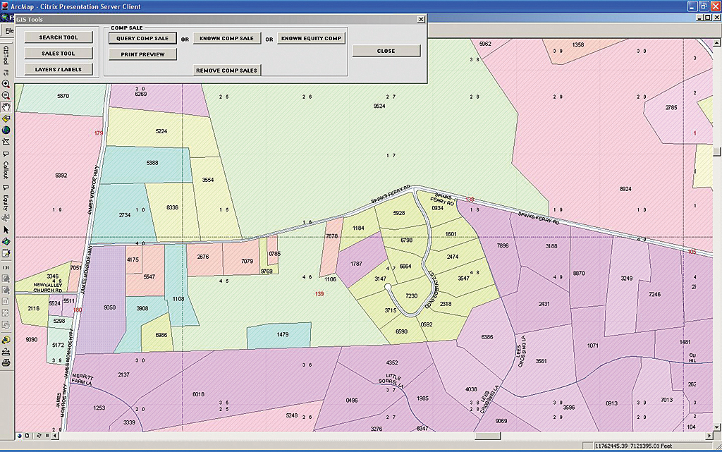
Loudoun County's spatial data includes land records data (e.g., parcels, addresses, and centerlines) maintained daily in the geodatabase. Assessor's data on residential and commercial properties is maintained regularly as tables in the CAMA system. An external DB2 database called Parcel Database System (PDBS) contains the weekly upload of CAMA data that is maintained by Loudoun County's Department of Information Technology for data distribution purposes. After identifying the information needed for the mapping application, an extract of PDBS tables containing the required fields is maintained in the GIS ArcSDE database and updated weekly. DB2 stored procedures are also used to instantly access the external PDBS database for creating callouts in the application or returning pertinent data by clicking on a map location. The application provides access to specific GIS data layers and labels those layers with associated data (i.e., PINs and street names). To make the map more readable, the parcels are symbolized by shading them using the assessor's neighborhood codes. Users can toggle between different classifications for other analyses. To highlight the difference between residential and commercial parcels, the residential parcels are symbolized with hashes and commercial parcels with dots. The Layer/Labels tool allows an appraiser to turn on/off a few more layers such as Buildings, Golf Courses, Zoning, and Imagery. In addition to adding layers, this tool also allows users to pick and choose three more labels, from a list of 12, to add to the display. The application has several tools for various functions such as identifying a parcel or a set of parcels. Clicking on a parcel lists all the assessor's data related to that parcel. Using the Polygon Parcels tool, an appraiser can draw a polygon on the map and generate a report with the assessor's data related to parcels within the selected area. Speeding up map rendering was one of the goals for this application. Searching for parcels based on PIN, historical tax map number, neighborhood number, land neighborhood number, and subdivision is a common task, and the GIS database was relatively fast, but searching for data stored in PDBS using stored procedures and rendering the map was very slow. To improve this situation, the Search tool lets users search parcels either within the county or within a selected election district that provides many more search criteria, such as searching lot numbers, occupancy codes, sale price ranges, and improvement size ranges. The parcels returned in the search are highlighted and the extent zooms to the selected parcels.
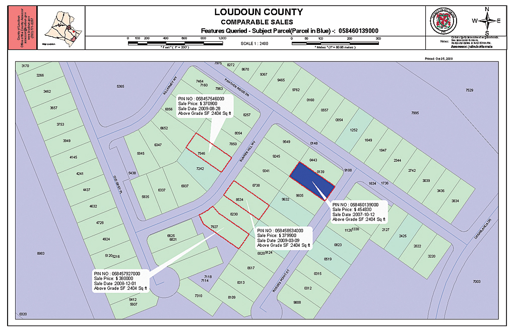
Selected parcels can be further analyzed using the Sales tool. Often, an appraiser needs to search for parcels sold around a particular parcel or within a neighborhood or subdivision. The Sales tool allows an appraiser to identify these parcels that have sold within arranged selected dates and at a specified distance from the subject parcel. These properties are highlighted and listed in a report that can be exported to PDF or other formats. Every April, taxpayers can appeal the assessed value of their properties. This process requires the Assessor's Office to provide three comparable sales to the Board of Equalization. This process is facilitated by the application's Comp Sale tool. This tool identifies the three most comparable sales for the appealed property. The appraiser can create a map showing the location of the subject parcel and comparable sales with callouts showing information such as sales price, sale date, and total price. These maps are used when the property is reviewed by the Loudoun County Board of Equalization. Future EnhancementsThis application, although successfully implemented within the Assessor's Office, has limitations. To expand access to parcel information, a Web-enabled program is planned. In addition, appraisers would like to use the application to create routes to sites they must visit, access Multiple Listing Service (MLS) data, and view photographs of structures and adjacent streets. These enhancements should help the Assessor's Office continue working as efficiently and effectively as possible. For more information, contact Julie Kottamala, GIS Programmer Analyst Jennifer Sanderson, Operations Manager David Torraca, GIS Manager Loudoun County Office of Mapping & Geographic Information About the AuthorsJulie Kottamala is a GIS programmer analyst who has been working for Loudoun County's Mapping & Geographic Information Office for two years. She holds a master's degree in computer science. Previously, she served for five years as a major in the Indian army and has worked as a GIS and remote-sensing senior analyst. Jennifer Sanderson, the operations manager for the Loudoun County Assessor's Office, has 14 years of experience in mass appraisal. She spent 7 years with the Sedgwick County Appraiser's Office in Wichita, Kansas, working in several different departments. She then moved to the Shawnee County Appraiser's Office in Topeka, Kansas, to run the commercial department. Sanderson moved to Virginia in September 2007 to assist with upgrading the software systems used in Loudoun County. David Torraca is the GIS manager in the Loudoun County Mapping & GIS Office. He has worked with Loudoun's GIS nearly since its inception in 1986 and has more than 20 years' experience in the mapping field. He holds a bachelor's degree in geography, a diploma in surveying and mapping, and a master's degree in public administration. |