ArcUser Online
FIMT is an ArcMap 8.3 extension developed by the Esri–Denver Professional Services Group that provides all the tools necessary to manage GIS fire incident data using a standardized geodatabase model and map symbology for fire incident mapping. Beginning with the 2005 fire season, FIMT will be the U.S. federal standard GIS application for fire incident mapping. Outside the United States, the Sustainable Resource Development ministry for Alberta, Canada, Forest Protection Division has put FIMT into production, and FIMT is also being evaluated in Australia and New Zealand. FIMT is based on the Incident Command System (ICS). (For more information on ICS, see "Incident Command and GIS" in the October–December 2004 issue of ArcUser magazine.) This method of managing fire incidents was developed for incident response in the United States, and it has been imitated by emergency response organizations around the world. The terminology, processes, and symbols used in the FIMT application have been developed and used by many organizations to standardize the creation of maps used to support a fire incident command. With the adoption of the National Incident Management System (NIMS), the Department of Homeland Security has established ICS as the standard method of incident management organization. FIMT consists of an ArcMap toolbar that furnishes fire GIS technical specialists (GISTs) with all the ArcMap tools they need to manage the GIS data required to produce maps that support a fire incident. As part of FIMT, a standardized geodatabase model was developed for storing fire incident features. This standardized model provides a consistent framework for all fire GIS personnel using FIMT tools. The geodatabase is created by FIMT from a stored database template that is installed with the application. The geodatabase streamlines uploading and processing of fire perimeter information at a national level and allows national archiving of spatial incident data in a standard format. Previous attempts to manage fire perimeters for a national database required extensive operator interaction to manipulate a variety of nonstandard data in various formats.
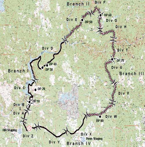
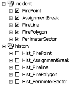
The FIMT toolbar includes utilities for creating a new incident geodatabase, opening an existing incident, initiating an edit session, managing incident metadata, and exporting an FIMT geodatabase to shapefile format. New incident geodatabases use FIMT's predefined spatial domain values for all North American and South Pacific coordinate systems. Shapefile exports include geodatabase domains that are exported with both the domain code and description text as matching attribute columns. FIMT supports access to multiple incident geodatabases from the same ArcMap document. An FIMT tool allows the user to switch from one incident to another when more than one incident has been loaded. The FIMT toolbar also includes buttons and tools for creating and managing fire perimeters and managing designations, command assignments, fire points, and fire lines. Fire perimeters are managed using several feature classes that work together through the FIMT tools. These feature classes act as a collection of objects that are used to represent the outer perimeter of a fire, assign portions of the perimeter to individual crews on the ground, and symbolize point locations that denote command assignments and line responsibility. Fire points are used to represent point locations such as drop points, spot fires, staging area hazards, and many other features using standardized symbology. Point locations are input into the database using heads-up digitizing from latitude/longitude locations received from the field or aircraft. FIMT tools are designed to accept several commonly used formats for representing latitude and longitude coordinates for both data input and selecting map locations that can be used to direct ground crews and aircraft to ground locations. The latitude/longitude input and output tools all accept multiple formats and perform conversions on the fly to and from formats including degrees, minutes, and seconds and decimal degrees. Fire lines are used to symbolize the current status of the fire perimeter, represent planned and existing defensible fire breaks, and symbolize the other linear features that must be managed by crews on the ground. The FIMT geodatabase contains two feature datasets, one for feature classes containing current incident features and one for feature classes containing incident history features. FIMT can archive the current incident feature classes to the history feature dataset and allow the generation of fire progression maps from archived fire perimeters. Also, the status of the fire can be queried and reviewed for a particular point in time. Overall, prototype testing that took place during the 2004 fire season has shown FIMT, in combination with ArcGIS, is a powerful tool for managing fire incident data. The improved cartographic output of ArcGIS and the benefits of a standardized database give GISTs the kind of advanced GIS tools necessary to support the growing demands placed on geospatial technologies during a high pressure incident response. For more information on the FIMT application, contact John Varner |