ArcUser Online
Since its formal introduction into the professional world in the 1950s, the concept of performance measurement has been implemented across a wide range of professional applications within local government. Whether it is applied within law enforcement, social services, public works, education, or economic development, performance measurement in local government can be a powerful tool to help elected officials and their staffs improve the quality, outcomes, and cost-effectiveness of services or programs. But what exactly is performance measurement, and how can it best be applied within local government? Performance measurement is defined in this article as measurement on a recurring basis of the outcomes or results and effectiveness of services or programs. The operative term in this instance is recurring. Consistent measurement or advancement toward specific outcomes is a critical part of all management efforts to improve results. An important aspect of performance measurement in local government is its customer orientation. Local government focuses on increasing benefits and decreasing negative consequences. This can refer to citizens who receive direct services or individuals or businesses affected by policy decisions or service delivery. In the early years of performance measurement, it was clear that state and local governments did not have adequate information on the efficaciousness of existing services. In contrast, today's performance measurement activities, such as tracking outcomes and service quality, have become common aspects of management processes. Yet, even with the tremendous advances in service delivery, there are still new technologies that can improve performance measurement and stimulate potential progress. Until the mid-1990s, local governments lacked one of the most important components of performance measurement—geography. "GIS's beauty lies in its simplicity. Anyone can use the maps to really improve the way we do things in Los Angeles." In years past, most government performance measurement reports collected information by service district such as reporting precinct or service yard. Some reports (usually academic and parts of one-time research projects) correlated long-term trends to more standard geographies such as census tracts.
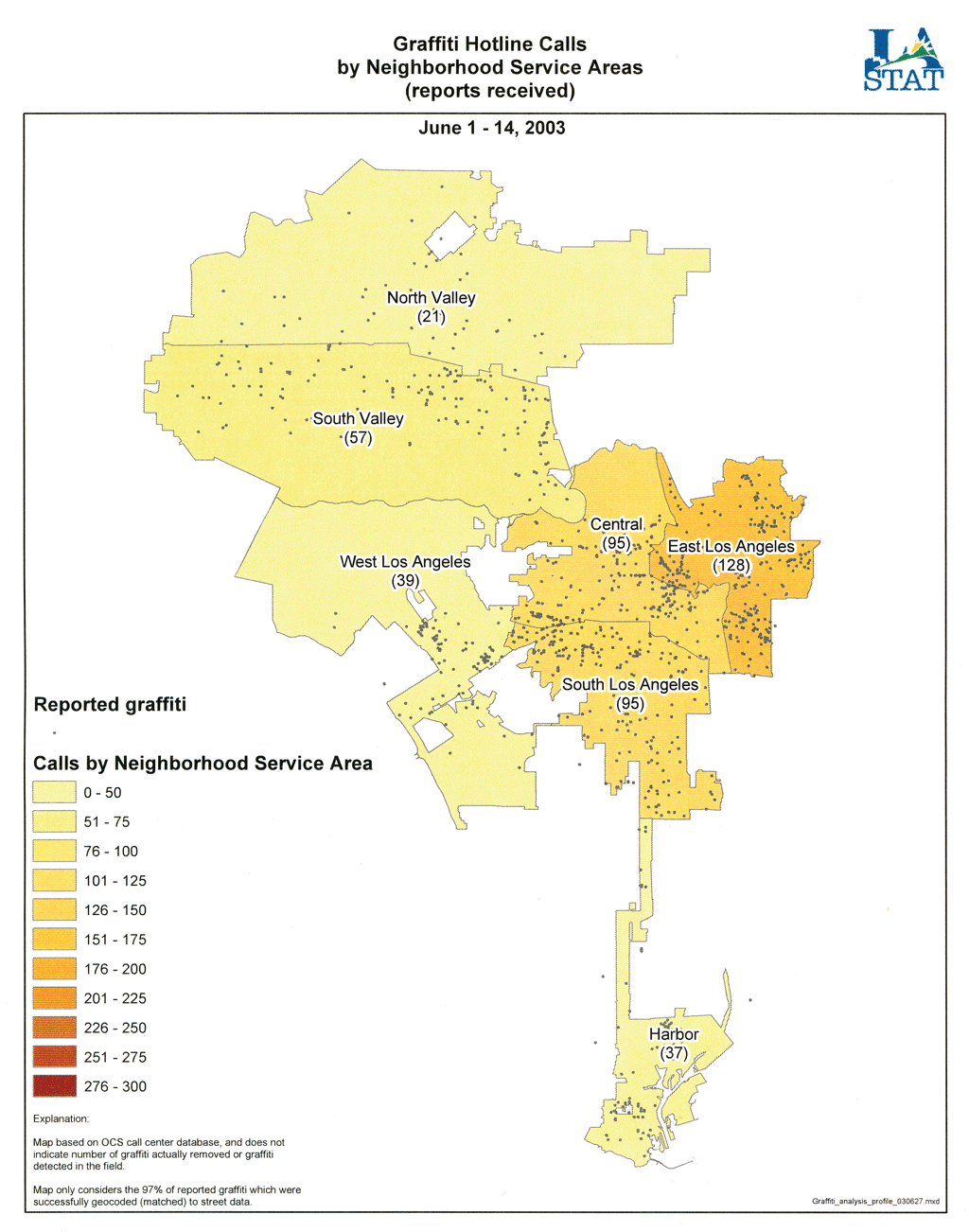
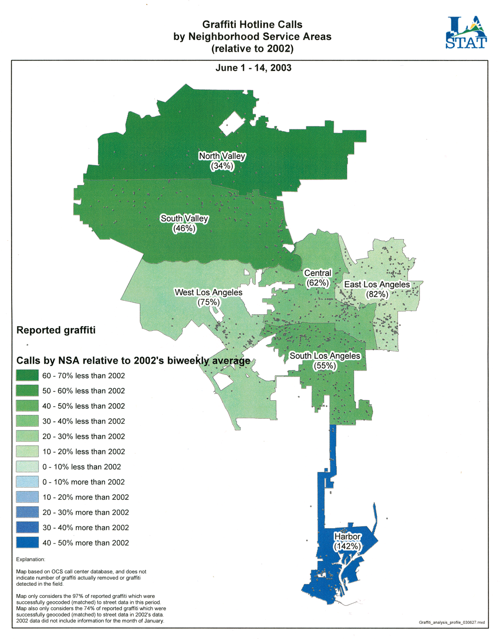
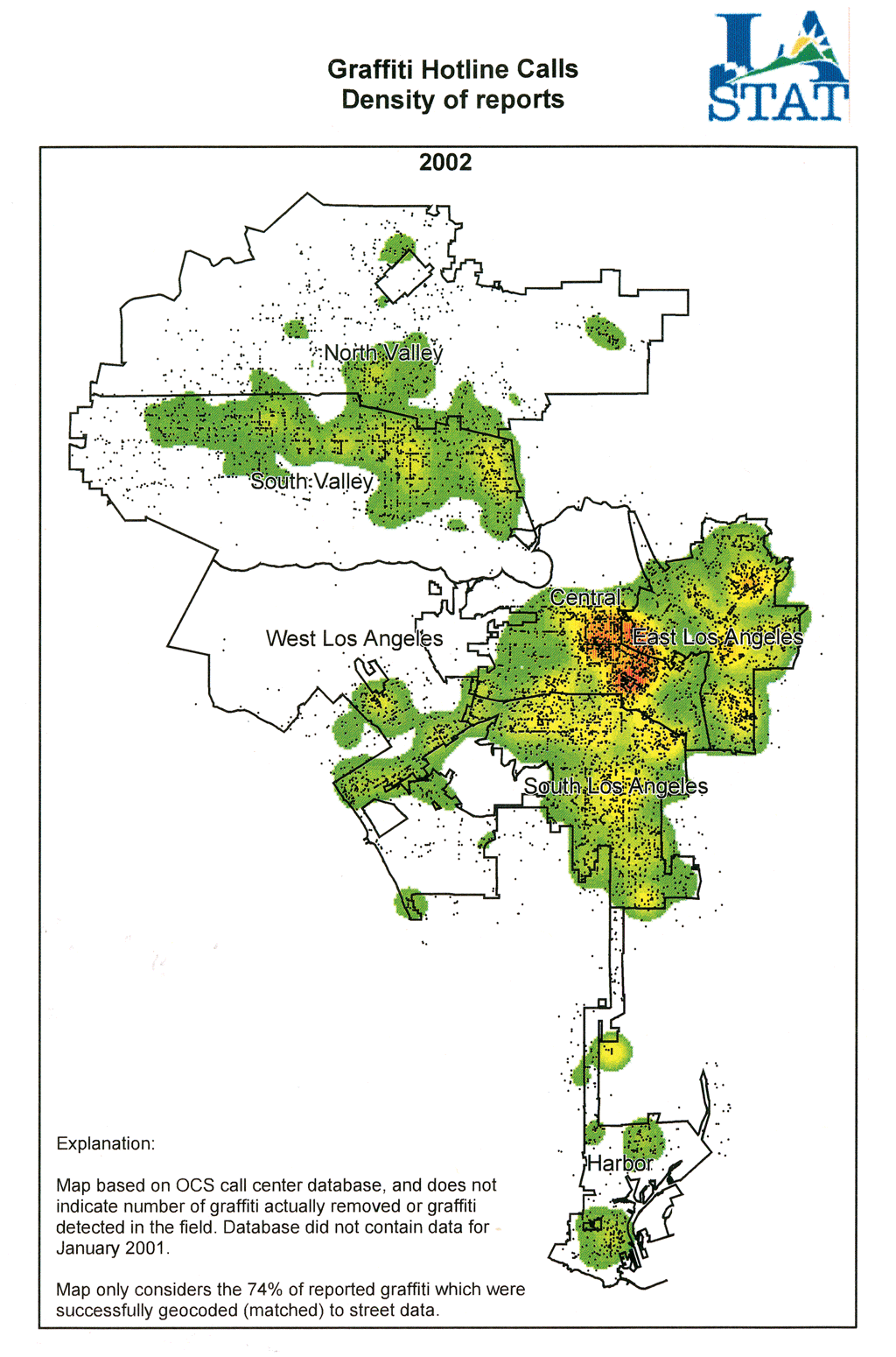
It took the maturation of commercial GIS technology to add the spatial component to performance measurement in local government. New York City's police department is credited with launching Computerized Statistics (CompStat), the first effective integration of digital mapping with numeric crime analysis in 1994. In the late 1990s, the city of Baltimore, Maryland, evolved this system into CitiStat, a bona fide municipal performance measurement system that looks at how various performance measures are distributed spatially. In its inaugural year, Baltimore's program produced more than $13.2 million in tangible fiscal impacts for a total start-up and operating cost of $285,000. Subsequently, similar "Stat" programs have been developed in other major metropolitan areas-often following an inspirational visit to Baltimore. Cities, such as Philadelphia, Pennsylvania; Los Angeles, California; Providence, Rhode Island; and Washington, D.C., have either implemented spatially enabled performance measurement systems or are currently working to implement similar systems. According to the Baltimore Business Journal, even several Iraqi labor commissioners visited the Baltimore CitiStat program in October 2003 for inspiration. What does GIS add to a performance measurement system? It adds the ability to see where problems are occurring, where certain solutions are working and where they are failing, and where government services are delivered well and where they are not. The traditional measurement of performance by predefined geographic areas (e.g., District 1 reports substandard performance while District 3 reports above-standard performance) can obscure information, especially in the absence of maps. Beyond merely displaying numbers on maps, GIS allows location-based data to be reaggregated by regional groupings that make more sense. For example, reporting graffiti numbers by council district may not highlight a problem as effectively as reaggregating data by school collection areas using GIS. So long as locations can be mapped in a GIS, the software can help to identify various data patterns and aggregations that cannot be discerned numerically. Conversely, aggregating data can sometimes obscure information. For example, the average response time for citizen complaints in a certain district, when aggregated, may appear acceptable, even when shown on a map. However, one portion of the district may be receiving above-standard response while another portion receives substandard response. In this case, GIS can display the locations of each problem (or problem resolution) in a disaggregated fashion that highlights patterns that might otherwise be missed.
Most government agencies using performance measurement and GIS would like to eventually see mapped and unmapped statistics be automatically generated from central data repositories and distributed over an Intranet or, in some cases, even the Internet. The concept fits well with the trend toward implementing so-called 311 systems that centralize access to nonemergency government services, because these systems provide a rich source for standardized performance data that can be analyzed with GIS software. These goals are often tempered by limitations in financial and human resources and other factors such as municipal data "islands" that are unable or unwilling to share information in a standard way; lack of up-to-date digital basemaps against which addresses can be geocoded; concerns about "airing one's dirty laundry" in public, particularly in front of the media; and even the lack of political will or capital to shake things up at city hall. As a consequence, GIS still tends to be implemented initially on one or two workstations for generating maps or on-screen displays for the benefit of the local government top brass. This has the positive impact of permitting analysts to experiment with the most effective means for augmenting the more traditional numeric means of assessing performance with the latest in GIS software technology prior to embarking on the more expensive and rigid Web-based alternative. Learning to walk before running is still a valid approach to life. Ongoing measurement of the outcomes of services provided by local government to its citizens is a worthy goal and one that deserves more attention. Performance measurement combined with GIS technology is not a universal remedy. However, neither performance measurement nor GIS can monitor or explain all outcomes. Ultimately, performance measurement only provides support for good judgment. But, for local governments that want to determine veritable outcomes and increase constituent trust, GIS improves upon traditional performance measurement techniques not only because "a picture is worth a thousand words" but also because maps can take the analytical process where mere numbers and words simply cannot go. About the AuthorDaniel Elroi is the president of Elroi Consulting, Inc., an Esri-authorized consulting firm specializing in GIS applications development, local government implementations, and outsourced GIS project management. For additional information, visit www.elroi.com. Elroi can be contacted at daniel@elroi.com or 303-696-1447. |