ArcUser Online
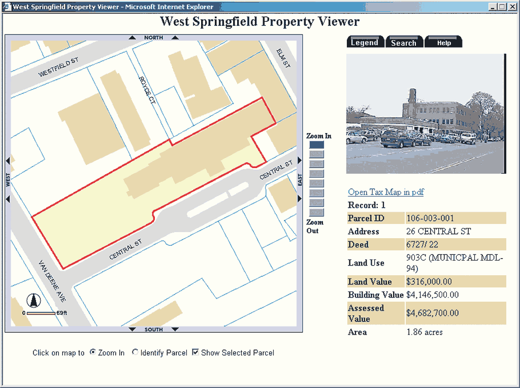
West Springfield is a small town of 28,000 people in western Massachusetts. To better serve the community and promote interdepartmental communication, the municipal government began digitizing and organizing its spatial data so it could be quickly and efficiently accessed. This process began in 1997. At the same time, staff recognized the need for Internet mapping capability that would let the public access data without contacting the town hall. West Springfield purchased ArcIMS along with other Esri software. Early AttemptsThe author, who is West Springfield's GIS coordinator, followed the philosophy of "one step at a time." With limited staff and resources, implementing ArcIMS initially seemed a little overwhelming. At that time, static maps in PDF format were meeting the town's needs. These maps were created using ArcView 3 or ArcInfo, exported into PDF format, and FTPed to the Web server residing outside the town hall. West Springfield's GIS Web site had been launched in early 2000. It featured tax, topographic, and planimetric maps in PDF format. After updating a map, the PDF had to be re-created and reposted. There was a major problem with this method: no way to search for a parcel. Locating a parcel required calling the town hall to find out the number of the map containing the parcel so the correct tax map could be downloaded. Getting additional tax information required another call or visit to the town hall. The desire to improve access to tax information led to a decision to create an interactive ArcIMS Web site that would let the public search for and view parcels and get the latest tax information conveniently. ArcIMS and Open Source SoftwareThe town maintains two different databases for its tax information-the spatial location of each parcel is stored as a polygon in an ArcGIS personal geodatabase. Other tax information is maintained in an Oracle database managed using VISION software. Parcel identification numbers (PINs) link polygons in the GIS to the tax records in the Oracle database. ArcIMS, the industry-standard mapping server, was an obvious choice owing to its robustness and scalability. However, choosing other pieces that would complete the system, such as the Web server for the user interface on the client side-was not as easy. Some factors that were considered included
With these things in mind, West Springfield's GIS coordinator began looking for inexpensive and easy-to-learn technology that would work with ArcIMS and provide a stable and secure solution. Based on conversations with network experts, further research, and the author's previous experience, ArcIMS was chosen with the Apache HTTP Server 2.0.42 and Apache Tomcat 4.0.5 Servlet/JSP container running Linux. Best of all, much of this software was free. At the same time, the town hall obtained a T1 Internet connection. This guaranteed faster upload speed and justified in-house hosting. Although installing and configuring Apache Tomcat with ArcIMS was a complicated process, an Esri installation guide for Red Hat Linux was found at the Esri Support Web site (support.esri.com). It provided detailed, step-by-step instructions that made the process much easier. The town's existing dedicated GIS server, a Pentium III with 866 MHz processor and 1 GB of memory, was chosen as the Web server that would host the Web site internally. Linux Red Hat 7.3, chosen for its security and stability, was installed and configured with the town hall network with the help of a network consultant. Apache HTTP Server; Apache Tomcat; and Java 2 Software Developers Kit, Standard Edition (J2SDK) 1.4.0 were downloaded and configured for ArcIMS 4.0.1 on a single server. Continued on page 2 |