The GeoWeb—A Vision for Supporting Collaboration
Over the past three decades, as GIS grew from a project-based tool to an enterprise framework, the world has become more urbanized, technical, specialized, and connected. While the world has seemed to shrink, its population has grown in size and its problems have increased in complexity. Goals, such as creating sustainable communities and preserving biodiversity, are challenging not only because of the size of the problems they address but also the interrelated nature of those problems.
 |
| The GeoWeb is a vision that can be realized only through the participation of GIS professionals. |
GIS grew out of the need to combine data and analyze problems in a geographic context. However, GIS is much more than a digital way to make maps and manage databases. Through integrating complex data from many sources, new information can be created. GIS is a framework uniquely suited for bringing information processes together. These processes range from measuring and analyzing to modeling, planning, decision making, and taking action. The knowledge produced by information processes can also be effectively disseminated using GIS. This results in better communication and allows for improved collaboration and coordination of efforts.
GIS has benefited from the same improvements in technology—faster processing, increased bandwidth, greater storage capacity, mobile technologies, and real time networks-that have advanced mainstream IT. As Esri's GIS software has evolved, it has moved over many platforms. From its beginning on mainframe computers, it has moved to minicomputers, then workstations and PCs, and now the Web.
The Web itself has been evolving from a static, published media to a dynamic, database-driven, collaborative environment that has been called Web 2.0. Applications for Web 2.0 recognize that value is added by users. The Web functions powerfully because it is both decentralized and collaborative. As a whole, the Web is moving to a services environment.
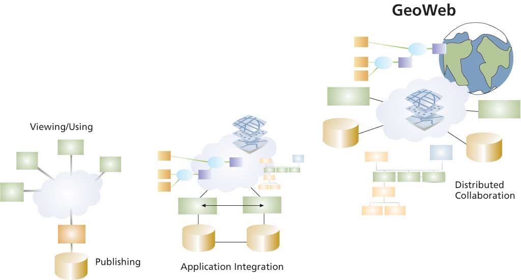
GIS is a vital part of the Web 2.0 evolution of information creation, access, and use that is transforming the world. Esri has responded to changes in the nature of the Web by developing GIS for the Web that empowers users and takes advantage of collective intelligence. This distributed global GIS has been dubbed the GeoWeb.
This vision of GIS on the Web has been described by Esri president Jack Dangermond as "a large, widespread, distributed collaboration of knowledge and discovery that promotes and sustains worldwide sharing and interoperability. I see a fabric of applications that work together synergistically for multiple purposes. Our current individual systems will be connected into a kind of system of systems."
The value of the GeoWeb, like other successful applications in the Web 2.0 age, is directly related to the data it handles. Historically, acquiring geospatial data has been the most expensive and difficult aspect of GIS implementation. Now, in an increasingly data-rich society, geospatial data is more plentiful and accessible.
Within the last decade, the quantity and quality of commercially available satellite imagery has increased many fold. More easily and economically acquired location data through GPS use, spatially enabled demographic data, and the real-time monitoring of both natural processes and human activities are other sources of geospatial data. The adoption of standardized data models and collaboration agreements have improved the efficiency of data collection, and the establishment of GIS portals and networks of data providers is making geospatial data widely available.
Esri's partnership with the Federation of Earth Science Information Partners illustrates how GIS facilitates data gathering and dissemination. The federation, a network of researchers and associated groups that collect, interpret, and develop applications for satellite-generated earth observation information, and Esri will develop the Earth Information Exchange portal for making data products and tools available to researchers, decision makers, educators, and others.
Not only is geospatial data more available but geospatial tools are also accessible to a wider group of users. Esri has moved GIS functionality from the traditional desktop to mobile devices that take advantage of wireless technology and server-side applications that let nontraditional GIS users benefit from GIS functionality.
ArcGIS Server uses this new approach for deploying GIS. Data is stored and analysis takes place on the server. ArcGIS Server supports many kinds of clients—smart clients, Web clients, and mobile clients.
With the introduction of ArcGIS Server, Esri expanded its work with the development community to encompass developers of applications that use GIS in addition to developers of GIS applications. ArcGIS Server supplies a strong development environment that includes .NET and Java APIs. To support developers in this wider community, Esri established the Esri Developer Network. For an annual subscription, all Esri developer technologies are available in a simple product.
Another Esri product that brings GIS to the mainstream IT world is ArcWeb Services. These GIS Web services are an innovative method for delivering current data and a broad range of geospatially based applications from location-based services to enterprise integration. Using standard Web protocols, ArcWeb Services supply focused functionality, such as geocoding, routing, and demographic analysis, and hosted services that make the most current data available. Esri and its partners have built and maintain services and extensive data layers. Hundreds of successful applications and solutions have been developed by organizations, such as the U.S. Postal Service, Nextel, and Trimble, using ArcWeb Services.
The GeoWeb is a vision that can be realized only through the participation of GIS professionals. The GIS community creates libraries of specialized content or specific geographies that can be accessed through portals such as Geospatial One-Stop. Instead of providing wide access to a single source of data, the GeoWeb can bring together vast stores of transactionally maintained data of many types along with geospatial services that can interact and be used to create new information. Existing services can be combined to make new services. Geocommunities that are currently segmented will work together in this loosely coupled environment and create new synergies.
The world needs better management based on an approach that is both rational and holistic, one that considers all factors and how they are related. GIS offers greatly enhanced information management through a geographic framework that promotes collaboration on scales that can address the challenges of a more complex world. GIS can help advance science, make communities more sustainable while supporting economic development, increase efficiency, and improve human health.
Articles in this issue of ArcUser demonstrate that GIS professionals are already making the GeoWeb a reality. A syndromic surveillance system developed at the University of Mississippi Medical Center incorporates coded real-time discharge data and dynamic spatial mapping and querying capabilities for rapid detection of disease outbreaks. The Global Biodiversity Information Facility's data portal integrates tens of millions of primary biodiversity data records from databases across the world. DenverGIS has created a one-stop online resource for location-based information relating to 30 departments in the city and county of Denver, Colorado. Designed for high accessibility by all residents, it generates maps and reports containing links to other Web sites, precompiled documents on related topics, and phone numbers.
These examples point to the rapid evolution of the GeoWeb, characterized by expanding GIS services, tools that make data exploration easier, and the more pervasive use of geospatial data to better manage the world.
|