ArcUser Online
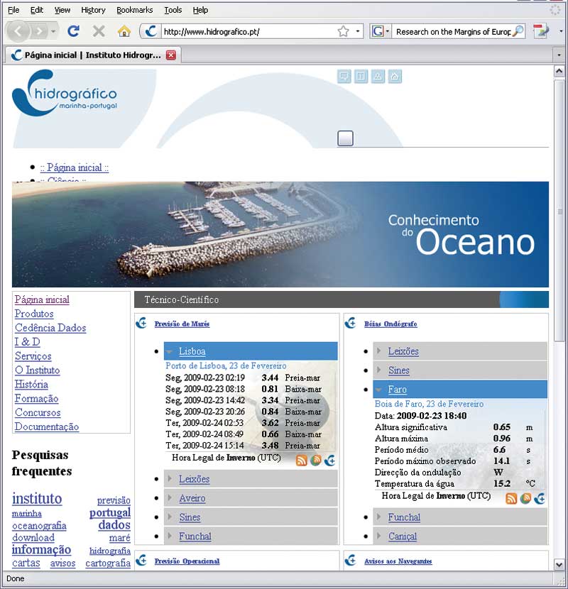
IHPT is the naval organization responsible for producing official nautical paper and electronic charts as well as conducting studies and research in marine-related disciplines such as physical oceanography, hydrography, marine geology, chemical oceanography, and navigation safety. For the last several years, IHPT has been developing an SDI called IDAMAR (an acronym in Portuguese for spatial data infrastructure for the marine environment) to support the production of technical and scientific data and information product management. It began as a departmental GIS named SIGAMAR, but the scope of the GIS was subsequently broadened, and the IDAMAR SDI now also provides the institute with the ability to respond to ad hoc requests for information from decision makers. IDAMAR SDI ArchitectureTo conform with military communications security rules, the IDAMAR SDI is actually composed of two similar systems: one connected to the Internet and one connected to a private military network. The public portion, available to all users, includes communications networks, databases, metadata, software, hardware, specialized human resources, outreach and support, data policy, internal data management processes, distributable information products, and online services. Communications networks Three communications networks support data transfer and online access to the SDI: an Internet connection, a private unclassified military network, and a private classified military network. The Internet connection supports data acquisition from several environmental sensors (e.g., wave buoys, radar stations) and the public dissemination of information products through www.hidrografico.pt. The private military networks provide access to the full system and support specific data and information requests. These networks support all internal processes for data and information product management. Databases and data models Several databases were developed using either DBMS- or file-based systems. The choice of system was based on the type of data stored and how that data could be most efficiently used. Data models for DBMS storage were internally developed for information processes except for chemical lab analysis data. A commercial laboratory information management solution, Thermo Nautilus LIMS, was acquired and extended so chemical data could be easily integrated with the entire system. Internally developed data models (when applicable) follow the S-57 standard for hydrographic data transfer. [S-57 is a digital data format standard.] The most relevant developed data model supports the hydrographic data warehouse (HDW). This database stores bathymetric soundings acquired by the IHPT and represents a major improvement in the cartographic production process because it reduces production time, eliminates procedures susceptible to human error, and improves the quality of the final product. Data stored includes data about the sea state (e.g., wave height, wave period, wave direction, and sea temperature) from ocean buoys; tide predictions and observations, horizontal control points; nautical chart and cell coverage; chemical analysis of seawater and sea bottom sediments; bathymetric navigation warnings; and medium-resolution satellite imagery. Not all data was supplied by IHPT—some data is related to activities of the Portuguese Navy. Data policy A data policy document sets out rules that govern data management and access in the IDAMAR SDI. This document stipulates policies for data classification, data access (both format and eligibility), and the associated costs. Some datasets are freely available to the public: near real-time sea state data; water temperature; sea state predictions for locations in the Atlantic and near Portugal; tide predictions for all principal and secondary ports in Portugal as well as locations such as Angola, Cape Verde, Guinea-Bissau, and Mozambique; some maritime administrative limits; small-scale bathymetric lines; and a small-scale converted Electronic Navigation Chart (ENC) cell for continental Portugal and the Madeira and Azores archipelagos. Metadata Metadata fact sheets are essential for inventorying, locating, and assessing the quality of geospatial data. These documents, which contain information about why, when, and where data was originally collected, are valuable from both a scientific and economic standpoint because they enable data reuse. Metadata is produced for all data, products, and services provided by the IDAMAR SDI. In accordance with the Infrastructure for Spatial Information in Europe (INSPIRE), metadata complies with the ISO 19115 standard. The metadata search engine was created to aid public access to the data. Specialized human resources Expertise in systems analysis, database systems administration, GIS, and Web programming was required for this project. Most contributors to the project have backgrounds in geography or earth sciences as well as master's degrees in various information technologies. This staff has developed the SDI and worked on ad hoc projects. Outreach
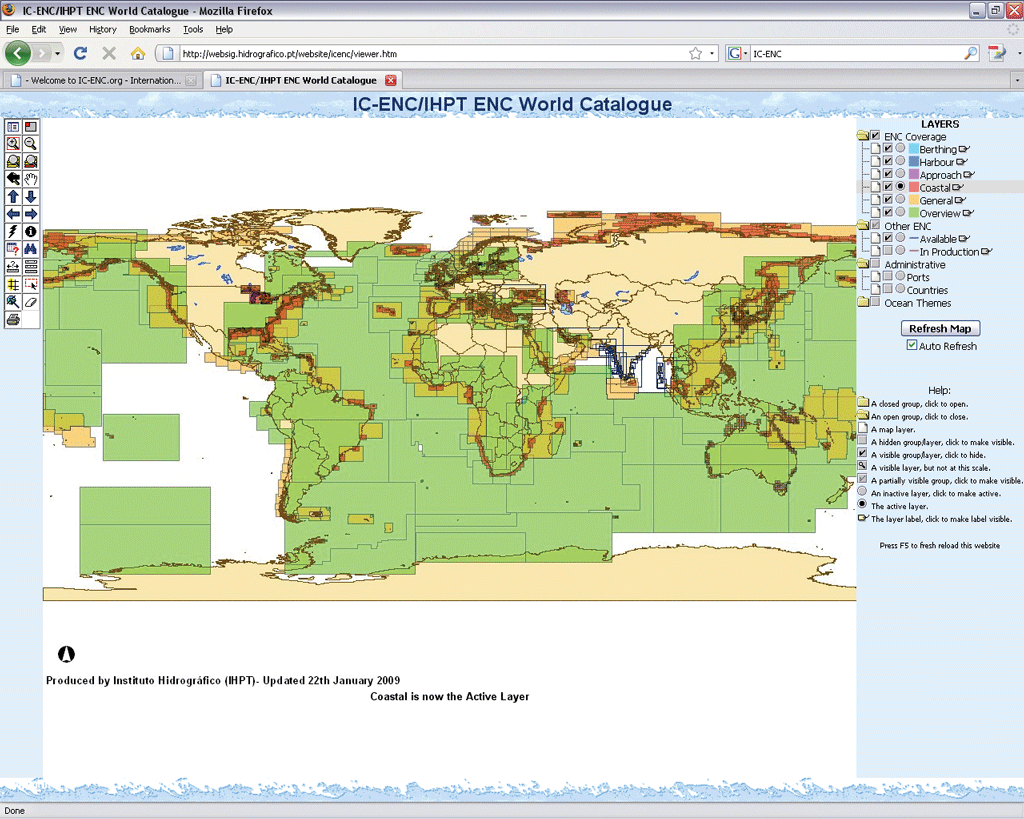
Because some geospatial analysis tasks should only be performed by scientists, courses that range from three to five days were developed to introduce scientists to GIS concepts and software. These courses are tailored to the needs of scientists and help spread GIS knowledge throughout the organization's scientific community while also providing tools that enable scientists to use GIS independently. This has allowed the organization's specialized staff time to work on both the SDI and advanced information projects. Software The IDAMAR SDI relies on Microsoft for its operating system, Oracle for DBMS, and Esri's ArcGIS for its GIS software. Specifically, the IDAMAR SDI makes use of ArcSDE, ArcIMS, and ArcGIS Server applications as well as single use and floating licenses for ArcView; ArcEditor; and the ArcGIS Spatial Analyst, ArcGIS 3D Analyst, ArcGIS Publisher, and ArcGIS Geostatistical Analyst extensions. Hardware The SDI is supported by four servers—two internal and two external. A variety of IHPT devices (PDAs, laptops, PCs, workstations, printers, plotters, and high-resolution scanners) are used for some SDI functions. Internal processes Implementing the SDI reengineered some IHPT production processes and introduced new ones. Setting up rules and workflows was necessary because making internal production more efficient was a main objective of the project. Offline products Generated in response to ad hoc requests for information, offline products are normally distributed as CDs or DVDs. Although not necessarily related to the internal products generated by IHPT, the SDI answers specific information needs, and offline operations are advantageous from a naval security standpoint. In addition, some paper products are still used for a variety of purposes including thematic cartography. In the last three years, more than 30 ad hoc GIS projects based on the SDI have been developed. Online products and services Online products and services provide broad access to the SDI. They are the most visible part of the public system that includes data catalogs, information products, and data services. Two Web portals (one internal and one external) allow users to obtain information products and services and provide the front end for data catalogs, data visualization applications, the metadata search engine, download services, and data services. Information ProductsSome information products are available from one or both of the Web portals, while others are furnished offline. The scope of products supplied depends on use and encompasses public services, commercial services, environmental protection, naval missions, and research and development. The list of products included here is not exhaustive, only representative. Exploring data with online data catalogs, data visualization, and metadata Several data catalogs allow users to explore data in IDAMAR SDI databases. Geographic interfaces assist in visualizing data such as horizontal control points, chart folios coverage, hydrographic surveys coverage, hydrographic soundings, sea bottom sediment samples, chemical analysis for water and sea bottom samples, tide observations, and sea state buoy observations. The ENC World Catalog is one of the most relevant catalogs available. Although not entirely related to IHPT (because its geographic extent is the world), this catalog helps sea navigators identify the available cells relevant to their route. The coverage data, collected by the International Centre for ENCs (IC-ENC), is available at websig.hidrografico.pt/website/icenc and is updated monthly.
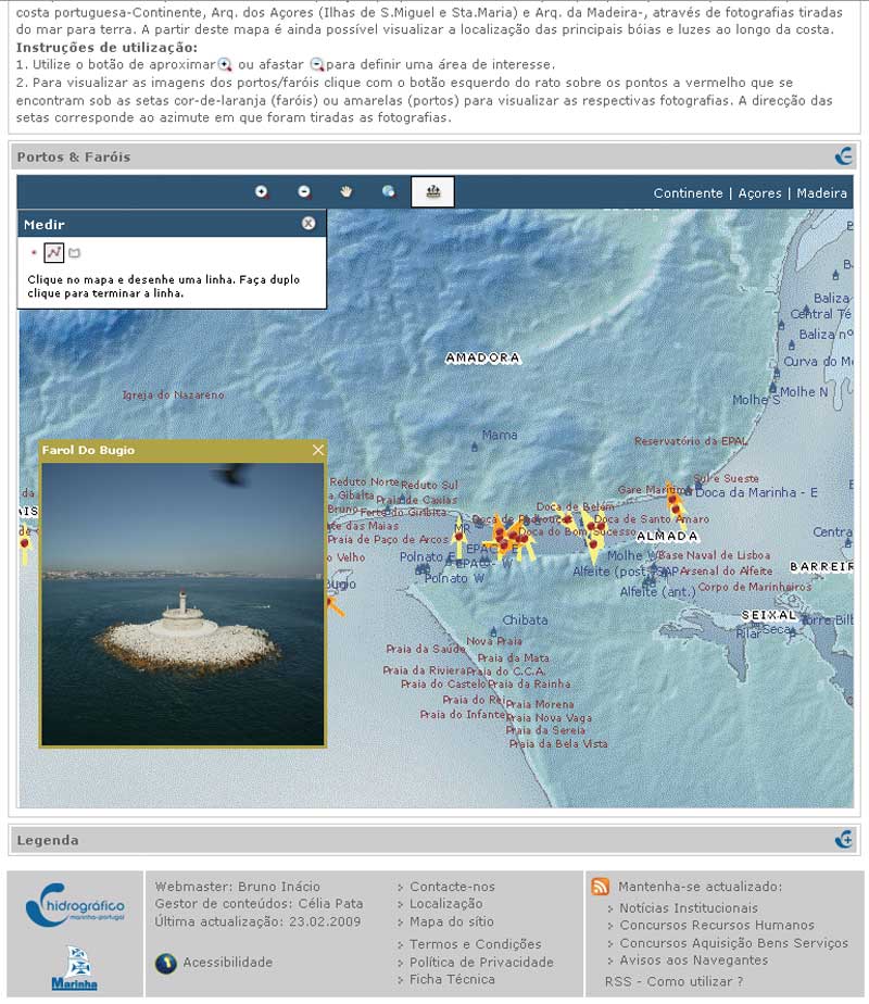
Information on the appearance of the coastline as it appears from the sea is very useful for sea navigation. A compilation of visual aids to the navigation of the Portuguese coastline is available from a customized ArcGIS Server Web site. This site provides links to photographs of coastline landmarks that help inexperienced sailors learn to recognize coast features. Mission impact diagrams, which display anticipated environmental impacts by military activities, are important to mission planning. Assessing impacts by using only a table was very time consuming and could be confusing. Since 2006, IHPT has been supporting the navy and national military joint staff with geospatially based, color-coded mission impact diagrams. This product, which is used on a daily basis, provides an exhaustive and efficient interface that shows factors relevant for a specific point of interest. Supporting marine research and development is another major objective for the IDAMAR SDI. Several information products have been developed that help scientists perform integrated analysis for a variety of marine disciplines, plan fieldwork, and communicate research results to the public. The Hotspot Ecosystem Research on the Margins of European Seas (HERMES) project is a perfect example of this type of support. More than 50 European partners are working on this project in seven different areas of the European shelf. A project GIS has been set up for each region to share data, coordinate fieldwork, and present results. Geospatial metadata has long been recognized as critical to the full utilization of SDIs by users and administrators. Three key aspects of metadata are data inventory, data search, and data quality. There are other aspects related to metadata that are valuable, but these are the major ones for the IDAMAR SDI. For an organization with environmentally based processes, maintaining a geospatial data inventory is fundamental. Gathering environmental data, especially marine data, can be very expensive. Performing the same measurement twice is a waste of time, money, and human resources, to say nothing of the cost of delays in acquiring necessary information. Currently available sampling methods (e.g., sensors, platforms) do not yet supply data sufficient to completely learn how the ocean works, so needless redundant sampling is a serious problem. Geospatial metadata search mechanisms are more complex than traditional, text-based methods because these methods require dealing with multidimensional (i.e., spatial and attribute) data. Geospatial fact sheets allow fast and objective searches for data of interest. As geospatial databases increase to terabytes in size, metadata becomes even more important. Data quality documentation is necessary to ensure that data can be reused in research and applications. Documentation prevents the use of data with inappropriate quality parameters that would adversely affect the quality of output and the decisions based on that output. Accessing data through RSS In addition to traditional geographic interfaces for accessing data, the IDAMAR SDI also provides access to some technical and scientific data via Really Simple Syndication (RSS). This protocol is useful for accessing data through low bandwidth connections or devices such as PDAs or cell phones. Tide predictions for the current date and the next three days, as well as near real-time data from sea state buoys located off the shore of continental Portugal and Madeira Island (updated every two hours), are disseminated using RSS. Navigation warnings are also issued via RSS. All links to this data are compiled at www.hidrografico.pt/rss.php, and only an RSS reader is required to obtain this data.Ad hoc independent projects Many projects developed from the IDAMAR SDI have been distributed via CD and DVD. ArcReader is used to explore the information supplied for these projects. Applications have been developed that address maritime safety; assist police investigations; support the numerous activities of the navy; and inform ship sinking crisis management and many other areas of public, commercial, and environmental protection service. Nearshore drift modeling, wave energy systems location, aquaculture structures location, and historical cartography are examples of applications under development. Future WorkThe IDAMAR SDI is a valuable asset that supports its main mission objectives: ensuring safe sea navigation, supporting the navy's activities, protecting the environment, and contributing to knowledge of the ocean. Ongoing data acquisition activities include converting historical analog data and products to digital format and registering this data in the system. A geospatial portal for better visualization is also being developed. Future enhancements include the implementation of GeoRSS feeds for the dissemination of technical and scientific data and the development of multicriteria geospatial analysis for mission impact diagrams that will improve environmental tactical decisions. For more information, contact Miguel Bessa Pacheco Learn MoreVisit www.esri.com/training to learn more about the instructor-led course GIS Portal Toolkit. |