ArcUser Online
Integrating GIS in secondary curricula is a relatively new concept. Finding an approach that will hold students' short- and long-term interest can be difficult. Obenhaus has succeeded in incorporating GIS in his math courses and has helped his students produce high-quality GIS projects. Students in the school's Distinguished Scholars program spend one hour per day during their senior year completing a senior project. This program offers students individualized lesson plans in a specific discipline. Since Obenhaus and another teacher introduced GIS to the school, student scholars in geoscience, biotechnology, and math have used GIS in their projects. Obenhaus has a simple approach: ask a question about something that is bothering you and use GIS combined with math to answer the question. "I teach math, which is more of a tool than a subject," explained Obenhaus. "By combining GIS and math, students use both tools to answer spatial questions about the world. Only with GIS can they quickly perform multiple analytic functions and see spatial patterns that are not apparent with a graph or table." His official GIS training was a two-week institute at a local university. Most of his GIS training has been informal. "I realized that GIS is very flexible. I played around with it and realized it could be used in so many ways in my classes. You don't need six months of training to have students do simple projects," said Obenhaus. When questions arise that he cannot answer, Obenhaus challenges students to figure out the answers before he does using ArcView online help. When questions cannot be answered using online help, Obenhaus calls on city and county GIS professionals who help. Some local professionals come into class. According to Obenhaus, students really enjoy learning from people who use GIS in their career. In Obenhaus' classroom, the first step in creating a project is having the students think spatially about a problem. He says that coming up with a question is the easy part, because most problems have a spatial component. "I learn from others' examples, so when I find good data online, I think about a question students can answer with it. When I see how professionals solve problems, I start to see the possibilities of what can be done in my own community." This year, his students are collecting data about the water quality of a local stream before, during, and after a construction project. They are using GIS to look at changes not only along the length of the stream but also over time. His next step is helping students figure out a problem-solving approach that combines math and GIS. Students learn the basic functions of ArcView during in-class lessons taken from the Esri Press book series Our World GIS Education. These textbooks include interdisciplinary GIS lesson plans for different academic levels. Once students have a basic understanding of GIS, they stop working on prepared lessons and start working on independent projects. In these projects, they ask a spatial question and find the data needed to answer it.
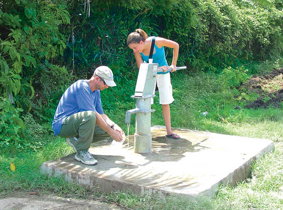
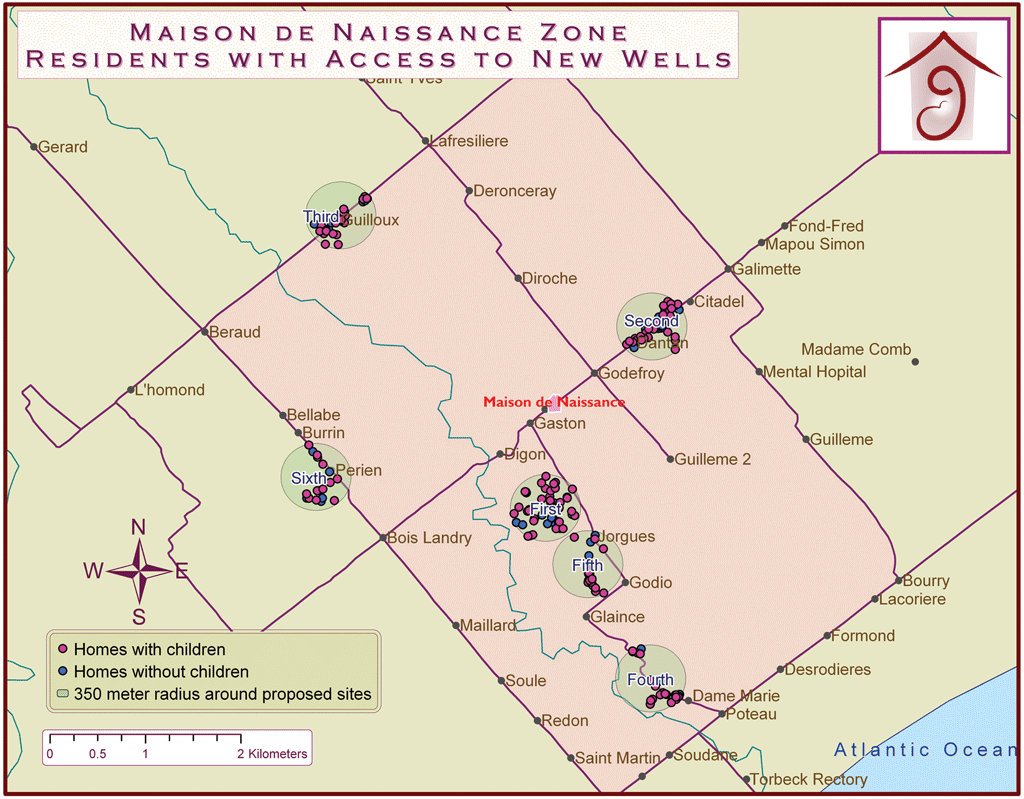
Obenhaus gives students the necessary tools, GIS training, a question, and an approach to problem solving. Then he lets students figure out a solution. "They pick up GIS really quickly when they play with ArcView during their own project, learning by trial and error," said Obenhaus. There is a common thread in his students' projects. In addition to answering a spatial question, students have followed Obenhaus' philanthropic example and worked on projects that serve communities, whether these communities or local or half a world away. Obenhaus and his wife do volunteer work for a maternity and neonatal clinic, Maison de Naissance, in a rural area of southern Haiti. The clinic's mission is to decrease maternal and infant mortality rates in an area with extreme poverty. Water-based diarrheal diseases are the leading cause of infant mortality in the developing world. When the clinic received funding to build wells to give more families access to clean water sources, the clinic director asked Obenhaus if he and his students could locate these wells. He agreed. When he began the project, Obenhaus had little knowledge of water testing and locating water sources. He began by asking a water analyst how to test water quality. He then traveled to Haiti with donated supplies and trained Haitians to test the water. This work was assisted by one of Obenhaus' students, Elizabeth Vidaurre, who went on to develop her own related project. A distinguished math scholar at Olathe North High School, Vidaurre combined her math and GIS skills in a senior project for determining how to select well locations that would benefit the greatest number of children in need. The water testing results, combined with the clinic's records on the number of children and where they live, were the basis for Vidaurre's research project. "We had two unique data layers that no one else had," said Obenhaus, who had students use ArcView to create basemaps from the data. "At first I thought it would be like playing a computer game, but it was serious work to use GIS," said Vidaurre. "It's a tool that helps you solve real problems. I could have done the project without GIS, but it would have taken much longer to analyze data and would not have been as accurate." With help from a Kansas GIS professional, Vidaurre used ArcView to create buffers around the homes of families living more than 350 meters from a clean water source. With this information, she analyzed where the highest clusters of children without access to clean water were located. The project was successful, but it took a few attempts to get it right. Obenhaus and Vidaurre worked together to find a quantitative approach for locating wells. Vidaurre ran chi-square tests to first determine if access to a deep-drilled well was an advantage. She found there was an advantage: the data showed a strong correlation between the presence of E. coli and hand-dug wells and open springs. By finding the best location for six wells, 1,180 children in need would have access to clean water. "Because of learning GIS, writing the paper, and presenting the results, I feel more prepared for life," said Vidaurre. "As a high school senior, I was networking with CEOs to fund-raise for my project. It helped me feel more confident as an intern working at a health systems IT company." The CEO and others were impressed by her project and, during her summer internship, had Vidaurre present ways GIS could benefit their company. Presentations about her work in Haiti not only resulted in donations for her project but made her a recipient of the Spirit of Philanthropy Youth award from the Association of Fundraising Professionals (AFP). After graduation, Obenhaus brought Vidaurre to Haiti to see the results of her work. Looking back on the experience Vidaurre said, "I have traveled in Latin America, but I had never seen a country that was so underdeveloped. I saw babies who were malnourished and kids with bellies bloated from worms. It was important to me to see the places I mapped and meet people. It wasn't just about wells, because personal experiences and new relationships remain most important to me." Obenhaus keeps Vidaurre, who is now a junior at the University of Rochester, up-to-date on the latest work done at Maison de Naissance. Difficulties in gathering data have made it difficult to show a decline in rates of pediatric water-related diseases. Nonetheless, Dr. Stan Shaffer, director of Maison de Naissance, sees the work of Obenhaus and his students as beneficial. "In poor communities, such as the villages of rural Haiti, it is critically important that health needs be carefully defined so that critical resources can be targeted for their highest impact," said Shaffer. "Steve and students such as Liz are demonstrating how mapping is an essential tool for organizing health information. You wouldn't attempt microbiology without a microscope, so it's not surprising that Steve Obenhaus says that we shouldn't attempt community health work without good maps." Obenhaus' students continue working on the wells project. For example, they found that not only were new wells needed, but old wells had to be repaired. The latest student projects look at other health-related issues such as what happens to the quality of water once it leaves a well. Students found that just because water is clean at its source does not mean people drink clean water, so they are now trying to figure out how collection and storage methods affect water quality. Obenhaus, who is clearly an inspiration to his students, downplays his influence. "It's easy to look good when you are surrounded by smart kids who work really hard to make a difference in the world," said Obenhaus. "To me, this is not work, it's fun." In 2007, Obenhaus was selected at the state level to receive a Presidential Award for Excellence in Mathematics and Science Teaching. Obenhaus' teaching approach can be replicated for advanced placement human geography, math, community service programs, and other courses, both traditional and nontraditional. For more information, contact Steve Obenhaus at sobenhauson@olatheschools.com. |