ArcUser Online
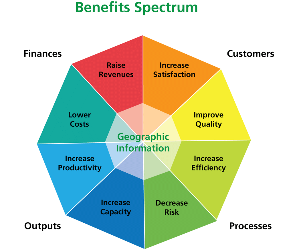
I devised the benefits spectrum [illustrated in Figure 1] because there are a lot of cost checklists about such things as project estimating templates and budget planners, but there was no equivalent benefit checklist. I basically thought, How can GIS improve the inputs and outputs to the process or the process itself? And what effects does this have on customers, cost savings, and so on? The main point of the checklist is to help the business case be focused on one or maybe two benefits—it's not the aim to deliver all the benefit types— otherwise, the message becomes blunted. Esri: What mistakes are usually made when creating the business case? KW: I think the most common mistake is getting the process back to front. By that I mean that if you do a lot of analysis but only engage with senior stakeholders at the end of the process—when you think you have the "answer"—it tends not to fly. You need to spend a lot of time with senior stakeholders getting their buy-in, and sometimes the detailed analysis can follow. Esri: Please describe the three phases—analysis, evaluation, presentation—of the business case process. KW: The first phase of the process is analysis, or defining a business problem, which is key to creating a successful business case. Rather than focusing on technical issues, the problem must be driven by the strategic objectives of the organization. Interviewing senior executives will help determine how GIS can reach business objectives. During the next phase, evaluating the GIS project, it's imperative to perform a rigorous analysis of risk associated with the project. It is necessary to create a project timeline, analyze costs and benefits, and determine that the project is feasible. Establishing implementation and maintenance costs of the project is the easier part, but benefits, both short and long term, are more difficult to determine. The benefits spectrum is a good starting point, as is the organization's finance department. The finance department can also explain the standard way that figures are presented to executives, which is the final phase of the project. In presenting the project, benefits covering quantitative tangibles, such as cost avoidance, and qualitative intangibles, such as environmental impacts, are both important. Different organizations tend to have varying approaches to the final product. My view is that the final business case should be a very short document or presentation, because all the hard work—detailed analysis, lobbying, etc.—has been done elsewhere. The real end product is the agreement to commission the project. Esri: Let's spend some time discussing benefits. What kind of returns are going to make executives buy in? KW: It's very difficult to generalize, but there have been a number of studies into this. The trouble is that returns accrue over very different time spans in different industries, and the return varies with project risk and the organization's own financial policies. Many organizations have a predetermined hurdle rate that a business case must deliver. I'd use that as a starting point. Although there is a focus on ROI, I think it's more about the spirit of the approach: quantifying costs versus benefits and showing the value of the GIS project. To be honest, it's just a normal procedure in most enterprise IT environments, and as GIS heads in that direction, it just has to do the same. The final report will include multiple financial performance metrics, such as NPV (net-present value), IRR (internal rate of return), discounted payback period, FCF (free cash flow), and ROI. Make sure data is transparent, keep records of how you arrived at specific numbers, and present simply with no false accuracy. Esri: Since you believe the focus should be on quantitative tangible benefits, what is the importance of intangibles? And how are they measured? KW: I've got a whole paper on that one! But I would say a few points. Firstly, intangible does not mean "cannot be measured," which is often a commonly accepted definition. Accountants have been measuring intangibles for centuries, for example, customer relationships, trademarks, and management skills. There is nothing that you can't put a useful measure on—if something is important to your business, then you must have detected it somehow. And if you detected it, it can be measured. I often hear users say, "Oh, the benefits of GIS are intangible," as if that's a showstopper for the business case. It's not. I'm not saying it's easy to get good measures of intangibles, but it can be done. The prism model of intangible benefits [illustrated in Figure 1] incorporates other more intangible, yet very relevant, areas of concern: political, social, and environmental benefits. Esri: Please discuss an example of an ROI analysis that showed the benefits of GIS. KW: At Esri (UK) we are working really hard at getting our customers to quantify the benefits that GIS delivers. This is really important. If we say GIS is going to save �100,000, we'd better show it. We always use our customers'/end users' numbers—we never derive them ourselves. We are now building a library of quantified benefit studies, and we use these as inputs into new business cases as evidence. Recently, we looked at refuse vehicle routing for a local government organization in England. The business problem they had was simple: rising costs such as overtime labor costs, vehicle running costs, rising fuel prices. A number of local authorities had already used transport consultants to review their refuse vehicle routes, but this organization wanted to be more dynamic—they recognized that refuse levels varied significantly from month to month due to seasonal lifestyle choices and industries, particularly tourism. The outcome was the authority could tune the GIS system month by month and avoid unwanted situations like one crew finishing early while another went into overtime. Fuel and operational costs were also significantly reduced, and all this also helped the organization with its carbon reduction targets. Overall, the return was many, many times the costs; they estimate savings of �110,000 per year. Improved customer service has also been a result of more efficient refuse collection. Keith Wishart, Esri (UK) Ltd.—Government Strategist
In 2000, Keith Wishart joined Esri (UK) as a consultancy program manager and is now part of the business strategy team. He is responsible for defining Esri (UK)'s central government strategy and also plays a key role in corporate strategy developments. Wishart has held other roles including Internet services manager. As a business consulting manager, he worked with a range of industries: central and local government, defense, utilities, and the property and commercial sectors. Before joining Esri (UK), Wishart spent two years with TENET Technology as a business development manager. Prior to his employment with TENET, he was research fellow at University College London. He is also an active member of Intellect, the UK trade association for the technology industry, and a management team member of that organization's software and government groups. He holds an MBA from Cranfield School of Management in Bedfordshire, England, and a Ph.D. from the University of Sheffield, Sheffield, England. |