ArcUser Online
Editor's note: Mapping real property has been important to cities since the earliest times. Some of the oldest known maps are cadastral maps from ancient Egypt that allowed property boundaries to be reestablished after the annual flooding of the Nile River. Prior to 1998, an inadequate cadastre and poor tax collection methods meant that the Costa Rican City of Turrialba was unable to generate the revenue needed to provide City services such as garbage collection and clean drinking water. With the assistance of the Tropical Research and Higher Education Centre (CATIE), the City developed a GIS that greatly improved its land records and doubled tax revenues in the first year. Turrialba, a small city located on the Caribbean side of Costa Rica, is 64 kilometers southeast of the country's capital, San Jos�. Home to almost 34,000 people, Turrialba's economy is dominated by agriculture--coffee, sugar cane, and macadamia nut production. The Rawlings baseball factory and ConAir processing plant are also located in Turrialba. Since the early years of the last century, Turrialba's municipal government has been collecting tax revenue and providing basic services such as drinking water, public lighting, and sewage services. In 1998, the City's database system showed that approximately 12,000 of the City's residents received services but only about 20 percent of these residents were paying for services. Insufficient revenue during the previous 10 years meant that the City had difficulty in providing basic services. The widespread belief that residents were not obliged to pay for services, such as drinking water and street cleaning, was part of the problem. In addition, poor tax collection methods and the failure to raise taxes limited revenues, caused services to further deteriorate, and increased the City's deficit.
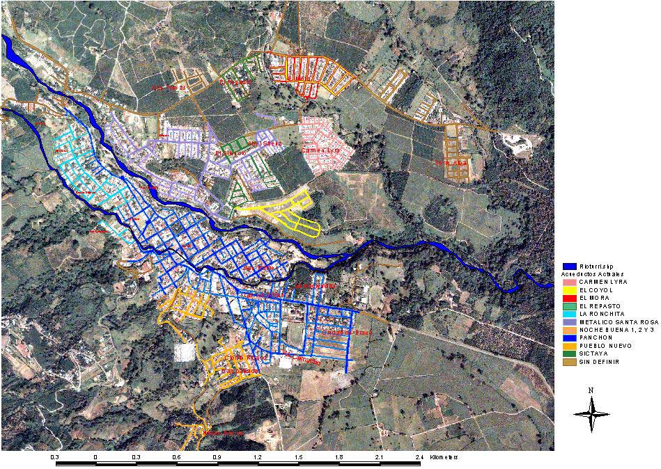
Before 1998, information relating to tax collection was stored in tabular form in a FoxPro database residing on a single 486 computer that lacked a backup system. This database contained serious errors in address, name, and identification number information. The lack of reliable original information made correcting these errors difficult. In addition, this system could only retrieve and print outstanding accounts one at a time. Citizens, critical of the poor state of municipal services, expressed their dissatisfaction and tarnished the City's image. The growth the City experienced during this period exacerbated problems caused by poor communication between City departments. Because files were often out of date or incomplete, the Tax, Urban, and Real Estate Tax Departments had little confidence in these records. During this period, the City collected less than $1,500 per day in taxes. The City's Board and the mayor recognized that GIS could be used to efficiently identify taxpayers and link tabular data in the municipal database to graphic information. The City began the MGIS project in January 1998. Working with the Geographical Information System Laboratory at CATIE, the City obtained and geocoded external datasets, verified information in the newly created database, and developed query and reporting tools. By the end of 1998, CATIE had organized the database system and linked graphic and literal information about taxpayers so that the system could identify service users by name, identity card, parcel number, or neighborhood. A MapObjects application handles geographic information, and a Delphi 3 application handles the accounting database. A Pentium II computer serves this information through an Intranet to computers in the municipal buildings. With MGIS, municipal departments have immediate access to current information that allows staff members to provide friendly and fast service to the public. Because MGIS integrates tabular data with graphic information, City staff can centrally access all the information relating to a service user with the click of a mouse. This information includes geographic location, personal identification number, a description of the property and the services received, and information on the state of repair. A complete and detailed breakdown of all a customer's accounts with the City is also available.
In the year after MGIS was implemented, tax revenue almost doubled. Revenues rose from $376,000 to $611,300. Projected revenue for 2001 was nearly $1.2 million, an increase of almost 300 percent. For the first time, revenue was projected to exceed outlays and the City will be able to retire the $160,714 deficit, pay the annual salary raise for workers, and have a surplus of $15,000. The City has developed many other uses for the system. Using MGIS, water springs, storage cisterns, and the water pipe system for the City were georeferenced. MGIS was also integrated with the Table of Values used by the Ministry of Housing (Ministerio de Hacienda) to assess properties. Property value information is thematically mapped using color to indicate property rates. The validation of properties and buildings is another useful application that will allow the municipality to get realistic information on values. The Geographical Information System Laboratory at CATIE continues updating and improving MGIS as well as assisting the City with queries. New uses for the system are developed every day and include mapping areas with health problems for the local hospital, locating water hydrants for the Fire Department, and identifying buildings that are vulnerable to fire. This project is unique in Costa Rica and perhaps in all of Central America. In Turrialba, the mayor and board in the municipality can base policy decisions on up-to-the-minute information provided by MGIS. Many cities in Costa Rica are interested in adopting a similar system. The system will be used to produce a set of geographic maps for the region. These maps will promote ecotourism in the area by providing extensive information on some of the most popular tourist attractions such as the Turrialba volcano, rafting areas, and archaeological sites. For more information on this project, contact Sebasti�n Salazar at ssalazar@catie.ac.cr. |