Better Document Management Through Georeferencing
Continued...
Dataset Metadata
For the purposes of this demonstration project, metadata from selected environmental studies performed on Oahu were provided by the National Ocean Data Center (NODC). Information on obtaining these datasets is readily available from the NODC Web site. Access information is automatically provided in the header on ArcView 3.x reports generated for metadata sets.
Once the above data was collected, the tables and forms listed below were developed in Microsoft Access.
- A location table containing the unique identifier for each record, a code for each geographic point, and a text label for each site
- A place name table containing the code for each geographic point, text label for each site, and text label for the bibliographic record
- An edit form for input of bibliographic information that automatically provides a unique number for each record and supplies a list of the geographic locations in a drop-down box
- A search form that allows keyword searching or searching from specific fields.
The search form is used as a database management aid. USFWS staff may also use this form for more sophisticated literature searches than those provided by ArcView 3.x. Files from the Hawaii Statewide GIS Program Web site were downloaded and used to create a view in ArcView 3.x. The initial view is an outline of the Island of Oahu that identifies significant freshwater streams. Zooming to the next level displays points labeled with Hawaiian place names. Each point is linked to an ArcView 3.x table containing bibliographic, metadata, or geographic information.
Using the Application
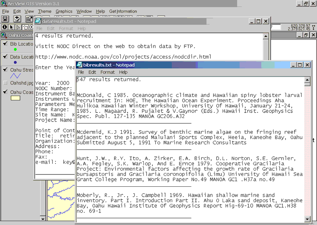
This application provides both graphic selection and query methods. Using the ArcView 3.x selection tool, the user can draw a polygon around the area of interest. Alternatively, the user may select geographically distinct areas by holding down the Shift key and clicking on the desired points. In either case, the bibliographic and metadata records associated with selected area(s) are highlighted and a drop-down list gives the user the option of receiving a report of the bibliographic records, the metadata records, or both. Selecting both options will display the information in two separate windows. Reports appear as text files that can be opened in Microsoft Notepad, an application that comes with Windows. These plain text files can be printed, saved, or used in another application.
 |
| Metadata and bibliographic results presented in a simple text format that can be viewed in Microsoft Notepad. |
Nongraphic search methods are also available. The user may do a limited keyword search for bibliographic or metadata information using the drop-down menu provided. Users familiar with ArcView 3.x can use Query Builder to locate information on features.
To assist users in accessing documents identified by a search, a Library of Congress call number is provided for each item that is held by the University of Hawaii Library System or the National Marine Fisheries Service Library in Honolulu. The University of Hawaii Library catalog is available on the Internet at libweb.hawaii.edu/uhmlib/index.htm.
At the conclusion of the project, the USFWS was provided with several products.
- An ArcView 3.x project with all associated tables, shapefiles, and programs
- A Microsoft Access database with all associated tables and forms
- A CD-ROM containing ArcView 3.x files that can be used for concept demonstrations and user education and training
The Future
Georeferencing bibliographic information provides users with a unique perspective and has potential for information mining. This concept works very well for subject-specific, tightly focused projects. Given its limited scope, this project serves as a fairly simple application that is of immediate use to environmental managers. Applying more robust indexing schemes and search engines will greatly expand the power and potential of this concept. Employing ArcIMS is a natural next step in the development of this concept.
Continued on page 3
|