Extending Disease Surveillance with GIS
By Seth Wiafe and Bill Davenhall, Esri Health and Human Services Solutions
In recent years, threats from disease outbreaks have increased in both number and complexity. New diseases such as severe acute respiratory syndrome (SARS) have emerged, and other diseases such as tuberculosis that were once thought in decline have reemerged after having developed resistance to known antimicrobial drugs. The dramatic increase in international travel and trade in recent years has provided opportunities for diseases to spread across geopolitical and international boundaries at exponential rates as demonstrated by the outbreaks of SARS and avian influenza.
These disease-causing agents threaten people worldwide and highlight the need for an active disease surveillance system. Disease surveillance provides public health officials with the information needed to detect and manage disease outbreaks. Successful disease surveillance activities require standardized methodology, appropriate tools for prompt data collection, accurate synthesis of the data, continuity over time, and—most important—timely dissemination of the resulting information to health officials and, as appropriate, the public.

GIS has emerged as a powerful evidenced based practice technology for early detection and timely, but considered, response to disease outbreak. It is an information technology that can educate health professionals and the public of the threat of emerging infectious diseases and the agents that cause them. GIS enhances decision making at all levels—local, regional, and national. From a management standpoint, the analytical capability of GIS also aids in planning disease surveillance activities that reduce cost and improve efficiency.
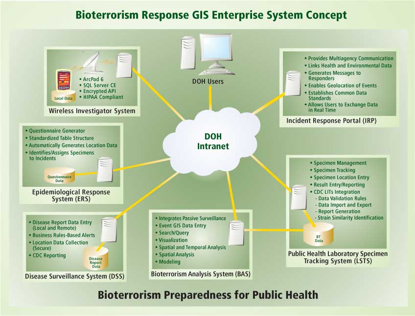
Responding to Outbreaks
Detecting changes in disease data early enough to take effective action is the primary role of surveillance. The earlier in the development phase of an epidemic a disease can be detected, the greater the odds of its successful containment. GIS is the technology of choice for collecting, analyzing, displaying, and sharing georeferenced data in a timely manner.
GIS aids outbreak response through
- Disseminating information about threats from emerging infectious diseases and the agents that cause them.
- Enhancing decision support at all levels-local, regional, and national. GIS can aid in planning disease surveillance activities and reduce costs associated with clinical and public health interventions by predicting outcomes before financial commitments are made. GIS can also aid in prioritizing the allocation of resources.
GIS provides a common platform for multidisease surveillance activities. Standardized georeferencing of epidemiological data can place disease surveillance data in context with information on demographics, the environment, administrative boundaries, hydrology, and vegetation. Mapping and spatial analysis reveal trends, dependencies, and interrelationships that would not be discerned in tabular format.
GIS can show information on disease occurrence at a variety of levels from regions to individual cases. Mapping graphically portrays the distribution and pattern of disease and the intensity of a disease or vector. This information can be related to the locations of service providers, customers, resources, and programs. The dynamic link between databases and maps provided by GIS means that updates to data are automatically reflected in maps.
Making Eradication Programs More Effective
In situations that require eradication of a disease, specific surveillance systems capable of detecting every case must be employed. Although specific disease control programs require different surveillance data, all programs require similar core activities—case detection, reporting, investigation, confirmation, analysis, interpretation, and action. They also share support functions such as the development of surveillance standards, epidemiology training, program supervision, mapping and communications, laboratory support, and securing of financial resources.
Preventing disease is the ultimate objective of disease surveillance. This requires sophisticated data analysis that can be used in developing control activity recommendations. GIS can map the locations of significant elements of this process such as occurrences of the disease, hosts, vectors, parasites, occurrences of drug resistance in vectors and parasites in human populations, and the intensity of transmission by the vector populations. Through synthesizing and continuously updating information on humans, vectors, and parasites and associating this information with environmental factors and control efforts, GIS can help make eradication efforts more focused and effective.
The Current Situation
In many countries, disease surveillance activities are focused on monitoring populations with a high incidence of disease, detecting outbreaks of diseases with the potential to cause epidemics, or measuring the success of eradication programs for endemic diseases. Existing disease surveillance systems rely heavily on routine reporting of diseases treated and health events by health care providers. Also, many public health epidemiological tools are only used once an outbreak has been reported.
In 2002, the United States General Accountability Office reported that multiple discrete surveillance systems have been implemented but are poorly coordinated and not closely linked to response systems. The result has been that occurrences of many diseases go unreported. This diminishes the effectiveness of even the most widely supported disease control programs. It also impairs detection of other known diseases and emerging diseases, and contributes to the development of antimicrobial resistance. Delays in detection can allow disease outbreaks to spread significantly before response begins.
Viewed globally, disease surveillance programs can be characterized in the following ways:
- They are not standardized and reflect the historic response to infectious disease threats in individual countries.
- Most surveillance activities are supported and managed by vertical disease control programs. Some programs are effective and linked to well-supported programs, while others are poorly managed and nearly inactive.
- In some cases, surveillance functions are disconnected from response efforts or national health policy.
- Some surveillance systems are outdated. Although new surveillance targets are added, old ones are not removed. The result: data that is collected but never used.
- Surveillance systems can become so focused on data collection and transmission that scant attention is given to using the data for decision making.
National surveillance data on infectious diseases is usually collected by a variety of ministries or departments.
Surveillance activities carried on by academic and research institutes and private sector and nongovernmental organizations are often not coordinated.
In the health sector, multiple surveillance systems operate in parallel, sometimes completely independent of each other. Funding by strong outside donors exacerbates this problem by supporting specific surveillance and control programs.
Continued on page 2
|