ArcUser Online
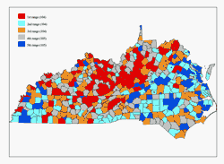
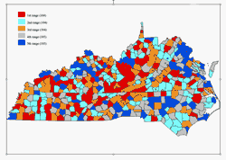
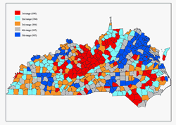
The author sought to determine which area-based socioeconomic measures would be most appropriate for public health surveillance in the United States. Specifically, the objective was to determine the relationship between the rate of cervical cancer for white females and indexes of social and economic status (SES). The study area consisted of the states of Kentucky, Tennessee, North Carolina, Virginia, and West Virginia. This project employed SAS business intelligence software, ArcGIS, and the SAS Bridge for ArcGIS. With the SAS Bridge for ArcGIS, spatial and attribute data and metadata can be exchanged between ArcGIS and SAS using a single interface. Linking Occurrence with Economic StatusIn 2005, the American Cancer Society estimates 10,370 women will be diagnosed with invasive cervical cancer in the United States and approximately one-third of the women with the disease will die from it. Cancer of the cervix begins in the lining of the cervix. The cervix is the lower part of the uterus that connects the body of the uterus to the vagina or birth canal. The part next to the vagina is the ectocervix. Most cervical cancers start where the vagina and ectocervix meet. To study the relationship between the rate of cervical cancer and economic status, the project used the Socio Economic Risk Index (SERI). SERI classifies people in public databases based on residential neighborhood characteristics and permits the calculation of population-based rates stratified by location. There are technical and conceptual obstacles to the adoption of area-based measures for public health. Currently, there is no consensus in the United States regarding which area-based measures should be used and what level of geography should be used to measure or monitor socioeconomic inequalities in health. By contrast, in the United Kingdom, several theoretically conceived and validated area-based measures of deprivation are well established. The Townsend index of deprivation permits meaningful comparisons and the monitoring of national, regional, and local socioeconomic gradients in health over time. In this study, information was obtained from the National Cancer Institute (NCI) (www.cancer.gov) and United States Census Bureau (www.census.gov) Web sites. Cervical cancer data for white females from 1970-1994 was downloaded from the NCI Web site. Geographic data for Kentucky, North Carolina, Tennessee, Virginia, and West Virginia was obtained from the census site as well as files on educational attainment, occupation, income, poverty, poverty ratio, tenure by person by room, tenure by vehicles, and value of housing. Based on these files, 10 categorical variables were created. Comparing IndexesUsing SAS software, levels were assigned for the 10 variables. Each variable was assigned five levels that ranked it from very bad to very good based on socioeconomic factors for the population of each state. Each variable was mapped to investigate any relationship with the cancer data. Finally, the three indexes, employing three methods, were defined and compared based on the accuracy of predicting the cancer rate in white females. Mapping ResultsTen maps were created using this data. These maps showed the distribution of cervical cancer rates in the general white female population, white females with higher education, and white females living in poverty for the five states in the study area. These maps revealed that the eastern part of Kentucky and the northern part of Tennessee have very high rates of cancer and very low rates of higher education. In contrast, Virginia has a very high rate of education and lower rates of cancer. Mapping the distribution of cervical cancer rates in the general white female population compared to cervical cancer rates for white females in poverty showed that eastern Kentucky and northern Tennessee have high rates of poverty, which is not the case in the eastern portion of Virginia. The first two methods used produced indexes that don't provide satisfactory predictions. However, Method 3 did produce satisfactory results in predicting cervical cancer classes. For example, 102 counties from class two were correctly predicted with a rate of 99.03 percent, while only two counties were misclassified. Discussion of the ResultsThe interaction effect method yields good predictions for rates of cancer in white females. Some kind of relationship can be determined between the rate of cancer of white females in the study and the various indexes of social and economic conditions. The author would like to investigate other methods in a future study. The integration of ArcGIS and SAS was very helpful in this study. The SAS Bridge for ArcGIS allows spatial data to be shared between these applications and links spatial, numeric, and text data through a single interface. This improves efficiency, produces more intelligent results, and communicates those results more effectively. For more information, contact Chakib Battioui, University of Louisville, at battioui@hotmail.com. ReferencesAmerican Cancer Society Web site (www.cancer.org), "What Is Cancer of the Cervix?" Krieger, Nancy, Jarvis T. Chen, Pamela D. Waterman, Mah-Jabeen Soobader, S.V. Subramanian, and Rosa Carson, 2002 (May 7), "Geocoding of U.S. Socioeconomic Inequalities in Mortality and Cancer Incidence: Does the Choice of Area-Based Measure and Geographic Level Matter?" American Journal of Epidemiology.
|
||||||||||||||||||||||||||||||||||||||||||||||||||||||||||||||||||||||||||||||||||||||||