ArcUser Online
The Harbor Discoveries Summer Camp is an environmental science day camp with a marine science focus. Harbor Discoveries is the first camp program to make extensive use of the Boston Harbor Islands National Recreation Area as a living laboratory for aquatic science education and environmental stewardship. Through a combination of hands-on science and traditional camp activities, the program seeks to foster an appreciation of the importance of habitats for all life and helps prepare campers to become future advocates for the planet. The academic component of Harbor Discoveries sets this summer program apart from many others. Each week's curriculum focuses on a particular theme. Using inquiry-based methods, the camp examines the interdependence of living things and compares similarities and differences among local habitats. By emphasizing scientific process skills, the program imparts informal science learning almost without students realizing it. Through hands-on, field-based experiences, participants are exposed to a variety of environmental issues pertaining to the marine environment. GIS and GPS technologies are integrated into the camp week called Sea Lab, which is focused on budding marine scientists in the eighth and ninth grades. The Sea Lab week uses current research practices to explore marine biology, ecology, and now geography. This week was chosen because it focuses on hypothesis-driven research, which allows spatial thinking and concepts to be easily integrated with these activities. To keep the GIS and GPS component a hands-on one for all campers, class size was limited to 12 students and counselors ensured that each camper had the opportunity to interact with the GIS system and a GPS unit. During this rigorous week, campers worked side by side with New England Aquarium researchers and camp counselors. They learned about scientific inquiry by developing hypotheses, performing fieldwork, and analyzing results. Before heading out into the field, they spent time in the classroom learning about the ecological components of the study, methodology, techniques, and technology. Classroom time also included fun team-building exercises. The aquarium is just a short boat ride away from the Boston Harbor Islands National Recreation Area, which provided an excellent field laboratory for the study of marine ecology. During the week, campers explored the six islands, took samples and measurements, and recorded and mapped the results. Real-World Examples of GIS UseThe New England Aquarium has used GIS in its research analyzing the spatial patterns of North Atlantic right whales (Eubalaena glacialis) relative to fishing and shipping activities, which are two of the leading causes of mortality for this species. Because geospatial technology is an important and growing component of the New England Aquarium's research, camp program directors wanted to incorporate GIS and GPS technology into the analysis of the data collected by campers. Researchers and counselors teamed up with campers and provided examples of how the aquarium employs these technologies in its research.
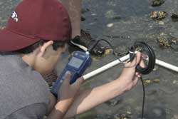
In addition, having a GIS and GPS component in the curriculum gave campers the opportunity to acquire spatial-thinking skills. President George W. Bush's High Growth Job Training Initiative has defined geospatial technologies as one of the leading job growth areas, and spatial thinking has been identified by the U.S. National Research Council as critical to success in the workplace and science. After a short introductory lecture on GIS and GPS technology, campers worked a small tutorial that taught them the essential elements of a map and how to add data and symbolize layers. Before heading out into the field, campers also tested GPS units. They could explore the units of latitude and longitude, as well as positional accuracy, and how this relates to potential problems with buildings that block the direct line of sight to the sky. Counselors gathered the coordinates students collected and displayed these locations using the GO TO X,Y tool in ArcGIS 9.2. These coordinates were displayed on a map with high-resolution photographs. Enhancing Crab Study with GISThis year's study focused on crab ecology. specifically crab population dynamics relating to water quality and substrate. Campers, organized into small groups, collected data on dominant crab species, diversity of crab species, percentage of females, and percentage of pregnant females. Along with the crab information, the campers collected information on water temperature, pH, salinity, dissolved oxygen, and substrate type. Secondary topics covered were water pollution, invasive species, and potential correlation between environmental variables and crab biology. As they explored the biological and physical diversity of this area, campers visited seven Boston Harbor Islands. When the campers arrived at the sampling site, they laid down a quadrat (a sample area, in this case, a square- meter rectangle) within the intertidal zone. Intertidal height varied at each site depending on the tidal stage, but the study mainly focused on midintertidal regions. At each site, the campers used the GPS units to determine the latitude and longitude position and recorded this information on a data sheet. Next, campers took measurements of various water quality parameters using appropriate instruments (e.g., pH meters, salinity meters). In the last step, all the crabs in the quadrat were collected and placed in a bucket to be sorted by species, then sized and sexed. Finally, it was determined which females were pregnant. At the end of each day, campers transferred data from field data sheets to a spreadsheet that replicated the data sheet but also automatically converted the degrees, minutes, and seconds obtained from the GPS units to decimal degrees for easy integration with ArcGIS.
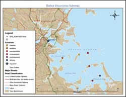
Campers also spent a night on one of the islands. This trip featured many fun activities and required that campers make at least five maps. Each group received detailed instructions that included how to bring the Microsoft Excel spreadsheet into the GIS program; change the symbolization; and add a title, north arrow, and scale bar to their final maps. Each group of campers decided which crab variables and water quality parameters it would map to make sure all the field measurements were represented on maps. This data was overlaid on a basemap of data layers downloaded from MassGIS (www.mass.gov/mgis/) to provide the spatial context for the mapped parameters. Each map was created from a template, but each group could choose colors and symbolization as well as a title for the map. The counselors provided guidance on symbols and titles that helped make the maps more easily understood. As campers finished their maps during the evening, counselors and campers discussed the findings from the week and how to display the results on the maps, emphasizing potential geographic and biophysical factors. Campers had access to tables of historic water quality data so they could compare their results to measurements over the past decade. On the final day, campers arrived back at the aquarium, bleary eyed but eager to finish the project. Office supplies were on hand to help campers assemble posters that explained their methods and findings and displayed the spatial patterns of their results. ConclusionGeospatial technology was easily integrated into the Harbor Discoveries Summer Camp and became a perfect complement to the field component of the Sea Lab week. The use of GIS and GPS technology will be incorporated into other weeks of the summer camp to allow for broader spatial education. Campers who participate in plankton tows will record their locations and map the plankton distributions. Other campers who will be sailing for a week will map their locations, record interesting observations along the way, and prepare souvenir maps of their travels to take home. The integration of these technologies increases not only the spatial awareness of the students relative to their travels during summer camp but also to the spatial relationships in the marine world. Next year, the camp directors will work on ensuring all study variables have logical ecological connections. AcknowledgmentsThe authors thank Esri for the generous donation of three ArcGIS Desktop ArcView licenses. This project would not have been possible without this support. Also, Harbor Discoveries thanks these founding corporate sponsors: New Balance Foundation, Germeshausen Foundation, Roy A. Hunt Foundation, TJX Foundation and the AGM Summer Fund, and the City of Boston. These organizations make it possible for 50 percent of the camp participants, who are Boston residents, to come to camp for little more than a minimal copay. Scholarship applicants must complete a two-part art and essay project to be eligible for a scholarship. For more information, contact Kerry Lagueux About the AuthorsKerry Lagueux is an associate scientist at the New England Aquarium where his research focuses on analyzing patterns of marine animals relative to oceanographic variables and anthropogenic impacts. He holds a master's degree in geography from Western Washington University and a bachelor's degree in geography from San Diego State University. His professional interests include spatial modeling, satellite tagging, marine GIS, geographic visualizations, and education relating to geospatial technologies. Heather Deschenes is the supervisor of the Harbor Discoveries camp and has worked at the aquarium for more than 10 years. She has helped forge many partnerships between the program and scientists willing to share their expertise with the camp participants. Maria Elena Derrien graduated with dual bachelor's degrees in biology and marine science from East Stroudsburg University and received a master's degree in marine ecology from the University of Massachusetts, Dartmouth. During more than 10 years working in the field of science education, she has taught environmental education and created curriculum for the New England Aquarium's Harbor Discoveries program. She is currently an elementary science teacher for kindergarten, first, and fourth grades at Buckingham Browne and Nichols School in Cambridge, Massachusetts. ReferencesJohnson, Ann B. "Spatial Thinking, Education, and the Workforce." ArcUser magazine, July–September 2006. |


