ArcUser Online
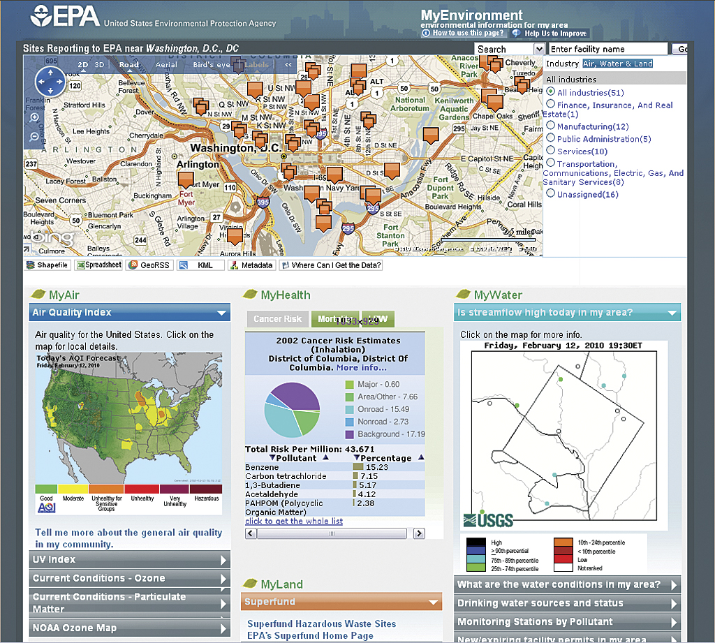
This article as a PDF . Have you ever wondered about the quality of the air and water in your community or what types of toxins you may be exposed to? Have you wanted to learn if adverse environmental factors were present near a home you are considering purchasing? While the answers to these questions would seem to require extensive research across numerous sources, Environmental Protection Agency (EPA) uses geospatial technology to deliver the environmental information that answers these and other questions using a single, easy-to-use online interface called MyEnvironment. MyEnvironment is a Web-based mapping application that provides data on environmental conditions from numerous federal, state, local, and private sources. The site incorporates mapping technologies and georeferenced data to organize and display everything from Superfund sites and other facilities that report to the EPA to daily ultraviolet (UV) indexes and local water quality data. Users can find personalized information by searching by ZIP Code or address. MyEnvironment links directly to relevant data sources and presents the information in several formats, such as maps, reports, and charts. MyEnvironment is just one example of how federal organizations are geospatially enabling their business operations. Many federal agencies are using geospatially driven approaches similar to the one used by the EPA for performing business processes and accomplishing mission goals. These agencies often face common challenges: coordinating across programs, combining numerous sources of information, and addressing reductions in budget and personnel. Geoenabled innovations throughout the federal government have helped agencies streamline mission-critical functions, saving resources and improving results while, at the same time, empowering individuals to learn about issues facing their communities. This article provides an overview of some geospatial projects implemented at federal agencies as a way to provide insights into the trends, challenges, solutions, and resources that could be leveraged by GIS users across the nation. Raising AwarenessGIS analysts working outside the federal government may not be aware of the types of geospatial applications and data that are available and may not see how the work of government agencies relates to their daily lives or jobs. In particular, the work of cross-agency federal initiatives, such as the Geospatial Line of Business (Geospatial LoB), may not be visible to nonfederal GIS personnel because these efforts tend to focus on coordinating the activities of federal partners. However, initiatives such as the Geospatial LoB are focused on coordinating the production, maintenance, acquisition, information architecture, and use of geospatial data to reduce the cost of federal government programs; inform decision making; and, at the same time, improve services to citizens.
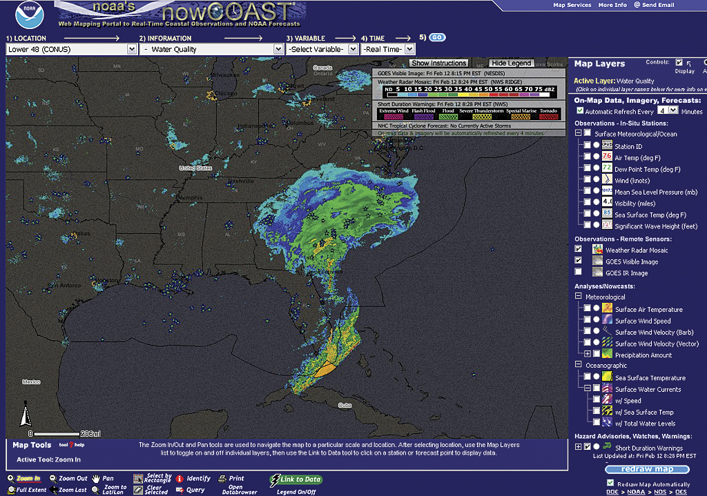
As key stakeholders in this endeavor, the public should be made aware of the Geospatial LoB efforts to maximize the value of geospatial investments. The Geo-Enabled Business (GEB) Work Group, an integral part of the Geospatial LoB, is composed of a number of federal agency representatives who volunteer their time to assist federal program managers and executives in identifying their geoenabled business needs, capabilities, and opportunities. The GEB Work Group meets regularly to identify new geoenabling opportunities and document existing examples that may provide a foundation for expanding knowledge about the capabilities, benefits, and applicability of geospatial technologies for addressing federal agency business functions. The agency-specific stories and examples provided in this article, collected from Geospatial LoB partners, illustrate how geospatial resources, approaches, materials, or products developed by federal agencies may be leveraged or reused by the public to meet different needs. To determine how geospatial technologies and approaches are used within the federal government to carry out its business, Geospatial LoB team members assembled use cases profiling federal programs or projects that leverage geospatial technology successfully and productively meet internal needs or provide information to the public. Interviews were conducted with members of the U.S. EPA, the U.S. Department of Agriculture (USDA), the U.S. Department of Justice (DOJ), the Bureau of Land Management (BLM), the Federal Emergency Management Agency (FEMA), the U.S. Geological Survey (USGS), and the National Oceanic and Atmospheric Administration (NOAA). Information collected from these groups was analyzed to identify common themes, approaches, and lessons learned. For more information on a particular example, contact the authors. The article concludes with an overview of where Geospatial LoB is headed. Examples of Geospatial EnablingA list of geoenabled use cases is summarized in Table 1. To highlight trends and application areas, use cases are organized into six categories: consolidating information, improving and streamlining operations, increased sharing and interagency coordination, automating and improving adherence to standards, providing GIS toolkits and suites of services, and including stakeholder outreach and input. Consolidating Information A key characteristic of GIS technology is its ability to bring data and information together. Many agencies leverage GIS to combine data from disparate sources to serve specific, mission-oriented goals. For example, NOAA created nowCOAST, a geoenabled Web site that provides access to real-time coastal data. This site brings together georeferenced information from numerous federal agencies, NOAA's internal resources, and 15,000 external sources. Providing timely information on coastal and climatic phenomena directly supports three NOAA mission goals: protecting national safety, serving society's needs for weather information, and supporting the nation's commerce. For NOAA, GIS created value by enabling an integrated, authoritative, Web-based source for information on coastal conditions that is easily accessible for the public, commercial purposes, and federal users. A different type of information consolidation is the development of the Common Land Unit (CLU) dataset by the USDA Farm Service Agency (FSA). FSA created the CLU as a comprehensive digital dataset that includes millions of farmland boundaries obtained from paper maps in more than 2,300 offices. The CLU helps FSA carry out mission-critical functions, including compliance and conservation, by combining digital farm boundaries with business data. The consolidated data helps FSA meet its mission goals while saving the agency time and resources. Improving and Streamlining Operations
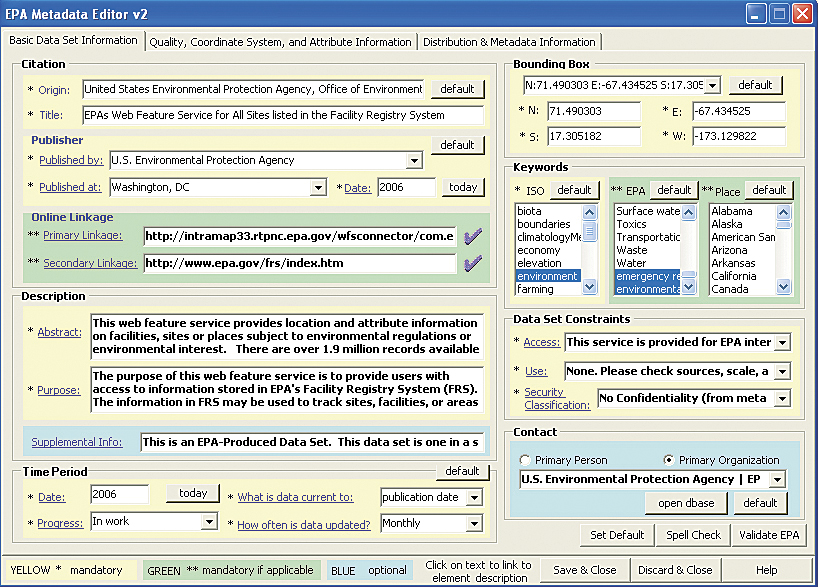
The TERRA program, also created by the USDA FSA, combines 27 formerly independent calculations and pieces of information into one geoenabled application. TERRA helps FSA weigh the costs and benefits of renting land from farmers to stop soil erosion—a mission-critical function that is part of the Conservation Reserve Program. Both farmers and staff members use this database to quickly visualize areas of protected land and improve decision making. Calculations that may have taken days in the past now take only minutes. Another example of streamlining processes is the National Institute of Justice (NIJ) Mapping and Analysis for Public Safety (MAPS) program at DOJ. Through the MAPS program, NIJ created a range of geospatial tools that focus on mapping incidents of crime to better inform police investigations and actions. These tools provide a number of functions ranging from hot spot analysis, journey to crime estimation, and near-repeat calculations. MAPS tools support DOJ's mission by improving the ability of law enforcement professionals to fight crime while simultaneously providing resources that support researchers studying law enforcement and crime. Increased Sharing and Interagency Coordination In addition to time and cost savings, many organizations use geospatial technology to facilitate inter- and intra-agency coordination. Enterprise Geospatial Services (EGS) facilitates spatial data sharing across FEMA by actively managing data collection, storage, and use. EGS facilitates data sharing between offices within FEMA and with other agencies, which curbs the tendency to create information silos within a branch or section. BLM developed the National Integrated Land System (NILS) GeoCommunicator to coordinate geographic data from numerous groups (internal, federal, and state agencies and tribal and local entities). Information compiled in NILS furthers cooperation across offices and assists in making land-use decisions. Additionally, EPA Metadata Editor (EME) fosters increased sharing of geospatial resources through better-quality metadata. This freely available application encourages users both inside and outside the federal government to produce high-quality, reusable metadata that can be shared with others. [For more information on EME, see "The EPA Metadata Editor" in the July�September 2007 issue of ArcUser magazine.] The coordination and sharing of information exemplified by these applications not only reduces redundancy but also provides decision makers with better access to higher-quality information and encourages agencies to coordinate their efforts to solve complex problems.
Table 1: Federal geospatial innovations Automating and Improving Adherence to Standards As agencies work together, providing data and services to one another, adhering to standards becomes increasingly important. One agency tackling standards related to address information is the Department of Housing and Urban Development (HUD). HUD uses geospatial data, especially address information, in its everyday operations and decision making. The agency's Geocode Service Center (GSC), a core part of its geospatial infrastructure, is a cost-effective solution that ensures the consistency and accuracy of address information for more than 17 data systems. GSC services are also used at HUD to validate addresses and match the same addresses within different datasets. GSC's high data standards have ensured data consistency across HUD programs and serves as a model for other agencies. The EPA also uses EME to ensure high-quality data inside the agency. EME creates metadata that adheres to the FGDC Content Standard for Digital Geospatial Metadata. Providing GIS Toolkits and Suites of Services
Many federal agencies provide value to their users by developing toolkits or suites of services. With these suites, users can access many geospatial tools easily. DOJ's MAPS, for example, provides law enforcement professionals and researchers with a complete desktop-based geospatial crime analysis kit. It contains two complete desktop geospatial systems, two profiling utilities, a crime analysis extension, a tactical crime analysis tool, linked charting programs, statistics programs, and a complete office program suite. In addition, NIJ provides Web-based crime tracking and prevention tools to augment the desktop software. FEMA also provides a variety of geospatial services to its users, including professional services such as geospatial project management, technical training, and systems engineering. Including Stakeholder Outreach and Input Many organizations recognize the crucial role that stakeholders have in creating and implementing a successful geospatial program or project. Numerous agencies reported utilizing stakeholders throughout the requirements gathering, application design, and development phases of application development. Several agencies continue to work actively with stakeholders to improve these geospatial applications. For example, while creating the CLU database, designers consulted FSA staff from offices around the country, key decision makers, and even farmers to create a tool that would assist in capturing CLU data and performing the functions FSA needed. NOAA, EPA, and U.S. Geological Survey have included stakeholders throughout collaborative design and implementation. Conclusion and Next StepsAs these examples show, geospatial technology has become a core component of federal government mission operations. Expanding GIS technology in a way that realizes the best value for the government and the public is critical for creating a sustainable, geoenabled future. The Geospatial LoB will continue working with partners to identify existing and new areas where geospatial technology may be expanded, reused, consolidated, and leveraged. For more information on the Geospatial LoB and its structure, visit the FGDC.gov Web site and read the Geospatial Line of Business fact sheet (www.fgdc.gov/geospatial-lob/factsheets). To become involved or learn more about the Geospatial LoB, contact Lew Sanford at lsanford@usgs.gov. About the AuthorsSarah Hammer is a consultant at Grant Thornton LLP and supports the geospatial line of business. She has a master's degree in public administration and a master's degree in international relations from Syracuse University. Jessica Zichichi is a senior geospatial consultant at Innovate!, Inc., and supports the Geospatial LoB. She has been working in the field of GIS for more than 10 years and holds a master's degree in computer science and bachelor's degrees in geography and environmental studies. |