Spring 2010
Spring 2010 |
||||||||
|
|
||||||||
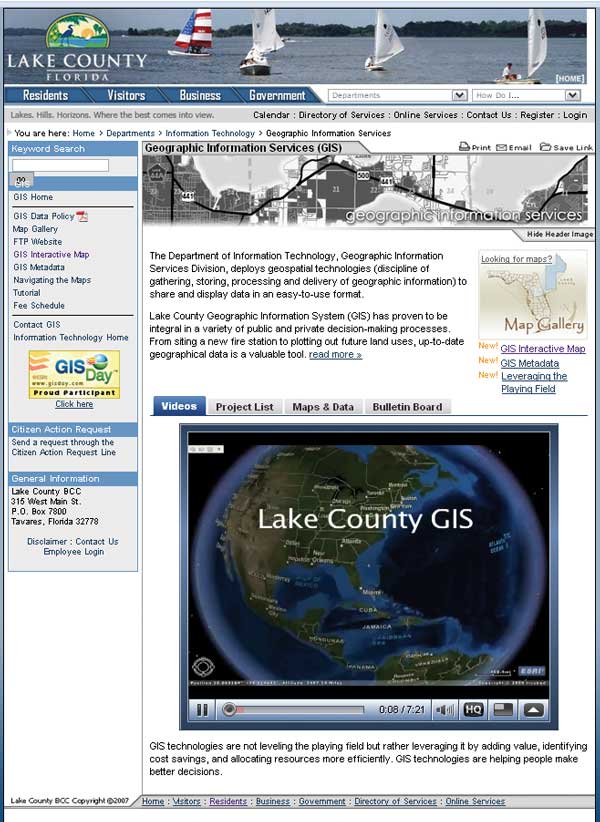
This situation provided an opportunity for the county to explore ways for taking advantage of GIS. GIS technologies are not just leveling the playing field; they are leveraging it by adding value through identifying cost savings and allocating resources more efficiently. GIS is helping people make better decisions. Lake County GIS uses a hybrid approach to data sharing and data custodianship. Using this approach, non-GIS staff are trained to use GIS technologies at a basic level within their departments. These users, or GIS liaisons, are mentored by the GIS Division staff. This model extends the county's use of GIS and allows the GIS staff to focus proactively on data analysis and modeling tasks. Over the past two years, the Lake County GIS enterprise environment has initiated many solutions that address real-world issues. GIS-enabled solutions enhance the level of service the county provides to citizens through cost savings, data analysis, and project modeling and visualization and can leverage county resources to provide risk management benefits. Explaining what GIS is and its benefits to someone who lacks a technical background can make for a long conversation. Lake County GIS needed a way to demonstrate the value of GIS and educate others in understandable terms and avoid spiraling into a technical abyss of deep explanations. Because a picture is "worth a thousand words," a video presentation seemed the appropriate medium for broadening GIS awareness. Lake County GIS decided ArcGIS Explorer could best communicate visually how GIS is adding value across county business functions because it can demonstrate through real-world examples how GIS technologies are providing exceptional benefit to the public. Both data providers and consumers of data could learn how GIS can better provide services to their customers. Using ArcGIS Explorer, Lake County GIS has created a short video called GIS Technologies: Leveraging the Playing Field that highlights the county's local data holdings and applications and includes embedded video, graphics, and text. The audio narration describes how GIS is being implemented in the county to make better decisions. The video had its premier showing during the Lake County GIS Day event in November of 2009 and was placed on the Lake County GIS home Web page so visitors can better understand how GIS is used throughout the county. This video is an excellent resource for marketing to stakeholders, fostering cooperation, and creating partnerships with local communities. ArcGIS Explorer is a superb marketing tool for Lake County GIS. Powerful and interactive ArcGIS Explorer presentations can communicate geographically, in a near real-time manner, what is occurring. The video has raised awareness of the new Economic Development Property Finder application, which was designed to attract new businesses and increase job opportunities within Lake County. The video also shows how GIS technologies contribute to local government business needs through applications such as the Proposed Future Land Use Interactive Map. Lake County also presented how GIS technologies assisted with grant application efforts for both mapping and data analysis. In addition to its role in creating the video, ArcGIS Explorer helps citizens utilize county GIS data for their specific needs. Its easy-to-use and powerful interface, available at no cost, can display scenarios and promote informed decisions. ArcGIS Explorer integrates projects and programs effortlessly and provides decision makers with a dashboard perspective for quickly and clearly understanding information. It is estimated that 80 percent of all databases can be displayed visually. GIS technology breathes life into Lake County's databases, which optimizes how and where county resources produce the greatest return on investment. For more information, contact Kevin Willis, GIS Director To view the video, visit the Lake County GIS home Web page. About the AuthorKevin Willis, GIS director, has an M.C.S.E. certification and an M.B.A. in information technology management. AcknowledgmentsCorey Mathis, GIS analyst, created and edited the GIS tasks in ArcGIS Explorer. Doug Woodyard, telecommunications manager, assisted with final video and audio adjustments; Mike Bowers, director of the Water Resources Management Division, did the video narration; and the Information Outreach Division assisted with embedding and formatting the video in the GIS home Web page. Download ArcGIS Explorer |