ArcUser Online
This article as a PDF . A GIS tool developed by a team of experts is helping scientists more effectively study complex coastal and estuary systems. Coastal flooding from extreme weather events threatens millions of lives and properties along U.S. coastlines every year. Especially hard hit are areas along the Atlantic Ocean and the Gulf of Mexico where over 60 percent of homes and businesses are within 500 feet of the shoreline. Yet, the ability to explore and study complex coastal environments with accuracy and speed has been limited, if not impossible. Affordable hydrologic models that work well on inland studies simply don't translate to coastal applications. However, more sophisticated supercomputer-based modeling techniques are cost prohibitive. In a pioneering effort, the St. Johns River Water Management District (SJRWMD) led a team of experts from academia, government, and industry in the development of the Analytical Framework for Coastal and Estuarine Studies (ACES) GIS tool, one of the first comprehensive coastal and estuarine tools. Still under development, ACES is designed to help scientists accurately monitor and manage the health of a complex estuary from within the Arc Hydro hydrologic environment. [Arc Hydro is a data model template for use with water resources applications that has been developed by Esri in collaboration with key state, national, and international contributors.] This tool has been used to support estuarine and coastal studies for the Guana/Tolomato/Matanzas Estuary, also a National Estuary Research Reserve for SJRWMD, as well as water quality studies in the Gulf of Mexico. [The National Estuarine Research Reserves are "living laboratories" that help researchers better understand coastal communities and find methods for dealing with the challenges these areas face.] Cooperative DevelopmentSJRWMD is responsible for regulating water use and protecting wetlands, waterways, and drinking water supplies along Florida's sensitive eastern coastline from Fernandina Beach to Vero Beach. The agency's Surface Water Quality Monitoring (SWQM) has used Arc Hydro to develop specialized hydrologic tools such as an automated pollution load screening model and a drainage area spatial data summary tool. Yet, while greatly beneficial, these hydrologic tools were unable to account for tidal influences, which directly impact water quality in estuarine waters. This limited the agency's ability to accurately manage water quality throughout the region. SJRWMD put together a technical team to develop ACES that included experts from SJRWMD, University of Florida, The Nature Conservancy, U.S. Geological Survey, and PBS&J, a consulting firm. The agency also put in place an expert review team that would be responsible for evaluating the end product developed by the technical team. The review team included the members from the Center for Research in Water Resources at the University of Texas, Austin; U.S. Army Corps of Engineers' Engineer Research and Development Center; and PBS&J. The technical team's first task was to establish a master plan for the tool development from proof of concept to production. SJRWMD stipulated that the tool must be applicable to all SJRWMD estuaries and include existing GIS-based tools and enhanced Arc Hydro geodatabases developed by SWQM. Goal-driven brainstorming sessions helped keep the technical team on track throughout the development process. The initial brainstorming sessions and literature review focused on the nature of an estuary, estuarine hydrodynamics, estuarine classification, existing GIS-based modeling technologies for estuaries, and synthetic modeling of water quality in estuaries. The team found that the first step in approaching the study of estuaries was the creation of a GIS-based workbench tool that could integrate multiple sources. Water in coastal areas frequently comes from multiple sources. These might include surface water flow, incoming tides, manmade waterways, and even in some cases groundwater. The tool had to allow for the creation of virtual estuaries and estimation of bulk parameters of the estuaries and facilitate development and integration of other models into the same framework. Conceptual ControlsIn the initial development phase of the ACES project, the technical team developed an estuary control volume conceptual model that connects features in the estuary physical model with elements contributing to the control volumes such as waters from coastal bases, oceanic constituents, riverines, and intracoastal waterways. Groundwater influence was not considered in this initial application since the influence is likely small as compared to the other elements. The team relied on a simple multiple linear regression (MLR) tool for evaluating relationships between constituents emanating from drainage areas and the measured values of water quality in the control volume. A more robust estimate of contributing areas may be obtained by using an iterative process that compared predicted and measured values while modifying the drainage area contribution. Throughout the effort, the team communicated extensively regarding various topics ranging from the deceptively simple, such as the definition of an estuary, to the complex and controversial modeling approach. Coastal PossibilitiesThe ACES prototype tool is composed of a GIS-based database of spatial and temporal data that describes the environment and an accompanying ArcMap-based toolset. Using ACES, scientists can essentially build a virtual model of the estuary they are interested in using topographic, bathymetric, and tidal datum data.
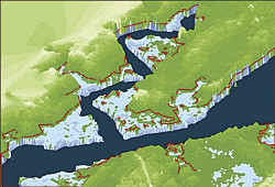
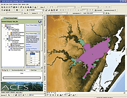
Within an Arc Hydro model, ACES can be used to determine estuarine bulk parameters (such as total area, high and low tide, volume, depth, and tidal flow) related to the shape of the estuary. With data related to flow rates into and out of the estuary, more complex parameters can be derived, such as residence time (the time water stays within a system) and flushing potential (an estuary's ability to flush a harmful substance). Using this information, the relative importance of tidal versus land-based flow on estuarine hydrodynamics can be assessed. Relationships between estuary water quality and flow rates can also be investigated. Using the ACES regression model capabilities, scientists can find the correlative relationships between the influential factors of upstream riverine drainage, coastal drainage, and estuarine non-point source pollution. Prototype in ActionAn ACES prototype was used to support estuarine and coastal studies for the Guana/ Tolomato/Matanzas Estuary, which is also a National Estuary Research Reserve for SJRWMD. Guana/Tolomato/Matanzas encompasses approximately 73,000 acres of salt marsh and mangrove tidal wetlands, oyster bars, estuarine lagoons, upland habitat, and offshore seas in northeast Florida. Along the northern section of the reserve, the Tolomato and Guana rivers meet the waters of the Atlantic Ocean. The southern section follows the Matanzas River, which extends from Moses Creek south of Pellicer Creek. The ACES tool was also used to support a water quality study of Copano Bay in south Texas, a project sponsored by the Texas Commission on Environmental Quality. A popular fishing and recreation site, Copano Bay is a large watershed with source waters from Aransas Bay and several rivers. Dr. Stephanie Johnson, then a doctoral student in the Center for Research in Water Resources at the University of Texas under Dr. David Maidment, wanted to develop an accurate water quality model for the bay. Johnson had already acquired estuary depth measurements, which she converted to volumes to model the processes within the bay. "To complete this study, I needed basic information, such as the bay volume and symmetry, which I could have calculated by hand using available contour maps, though it would have been a tedious process," said Johnson. Working with the ACES development team, Johnson used the ACES program to automatically develop the necessary estuary volume versus depth curve for use when computing the total maximum daily load of pollutants. "Through the ACES program, I was also able to create highly visual images that I incorporated into my larger water quality model and used to communicate with various nontechnical stakeholders," added Johnson. In the near future, environmental scientists at SJRWMD will use ACES to explore the estuaries along the northeastern coast of Florida, including the mouth of the St. Johns River, the Indian River Lagoon, and the Nassau and St. Marys rivers. ACES presents a wealth of possibilities for the exploration and analysis of estuaries at universities and within water management districts. This tool will continue to evolve in functionality and application to help coastal experts more easily explore and understand complex coastal environments. About the AuthorsSandra Fox is an environmental scientist with St. Johns River Water Management District (SJRWMD). She can be reached at SFox@sjrwmd.com. Stephen Bourne is a project manager with the PBS&J Water Resources Technology group. He can be reached at 404-895-0753 or sfbourne@pbsj.com. |


