April - June 2006
April - June 2006 |
||||||||
|
|
||||||||
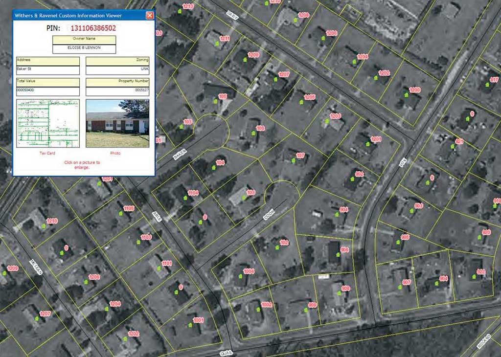
Bladen, Pender, and Columbus counties, among the 10 largest in North Carolina, updated their GIS systems to reduce emergency response time. However, the updated information will also benefit the departments of health and planning and the public school system. Although the counties' systems are similar, the systems were not linked. Esri business partner Withers & Ravenel used Esri software for all phases of the project including field collection, addressing application development, and the CAD mapping interface. An ArcPad custom software application loaded on an MDT (i.e., a laptop computer mounted in a service vehicle) allowed teams in the field to automatically download information to a central database. Two-person teams gathered data, using Bluetooth-enabled GPS units. [Bluetooth is a short-range wireless protocol.] As one person captured the location using GPS, the other team member made a time-stamped digital photograph of the structure. A grid system covered the county. Once the grid areas were defined, the mapping procedure began. MDTs also contained the most recent GIS data for the county including aerial photographs overlaid with property boundary lines and the master street address guide used by the 911 Emergency Services Department. As address data was captured, GIS technicians began the labor-intensive process of verifying street ranges by address matching the existing 911 address database and comparing it to data collected in the field. When an inconsistency was identified, the problem was either rectified through database alteration or, in extreme cases, by assigning a new address to the resident. County information was updated through a user-friendly GIS interface. Reverse-geocoding, a key feature of the GIS application, allowed the county address office to assign addresses automatically once address ranges were defined. The reverse-geocoding module provides an accurate, mathematically defined address for a location and stores it in a central database that is accessed by 911 dispatchers. This method is more accurate and less time-consuming than manual address assignment. After all the information was downloaded to the main GIS database, a spatial join was performed between structure location data and parcel data. This allowed each structure to be represented as a point within the correct parcel. The database was then queried to examine parcel tax value versus structure codes. In Bladen County alone, approximately 350 structures that had not been permitted or put on tax rolls were identified. To create awareness that field teams would visit each county area, information about the project was communicated to the public via radio, TV, and newspapers. The county printed and distributed brochures, in both Spanish and English, that explained the project's purpose and data collection teams' schedule. A Web site developed for county officials allowed real-time tracking of project progress. Applying GIS to data gathering was innovative and successful. The program integrates tax, planning, and emergency management services datasets; shares fiscal resources; and improves communications. All departments will be using the same information for forecasting and planning. This information reduces the need for expensive aerial photography of the counties and reduces the costs of tax revaluations. Of course, the most important benefit is improved response time for emergencies. The benefits from the 911 address update and verification will serve the citizens well for years to come. Larry Hammond, Bladen County GIS director, said, "I believe that this one single project—because of the variety [of] needs it will satisfy—will not only pay for itself but reap many dividends as well." For more information, contact Eddie Staley, GISP |