April - June 2006
April - June 2006 |
||||||||
|
|
||||||||
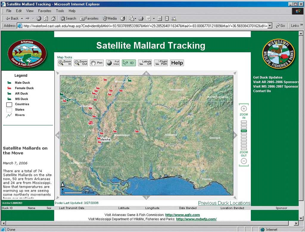
Mallard ducks captured in Arkansas during February and March are fitted with platform type transmitters (PTTs). PTTs acquire and transmit locations at preprogrammed intervals. After these location transmissions are processed, reliable locations are automatically posted to the ArcIMS site where biologists and users may track the ducks' migration. This application answers the oft-asked question, "Where are all the ducks?" Tracking mallard migrations via the Internet has become increasingly popular with sportsmen throughout the Mississippi Flyway and AGFC biologists since it was first made available in late November 2004. Why Track Mallard Migrations?Mallards migrate from the breeding grounds of the north central United States and south central Canada to wintering grounds of the south central United States. This migration has been well documented in scientific literature. Through band recovery data, researchers have pieced together the common breeding grounds and wintering areas used by many mallard populations. However, band recovery data gives no information on the movements of ducks between banding and band recovery locations. Although this information has been useful in identifying areas used as breeding and wintering grounds that need habitat conservation, there is little information on migration stopover areas. Stopover areas are used by mallards to rest and feed so they can complete their migration. These areas are just as critical to waterfowl populations as wintering and breeding habitat. Recent advancements in satellite telemetry have made it possible to fill in the gaps in band recovery data. AGFC's project will pinpoint the winter stopover areas of greatest importance in Arkansas and allow the agency to focus limited habitat management funds on these areas. Managing Satellite TransmittersTracking the mallard migrations is a costly process that requires the cooperation of many people and the sometimes difficult mallards. The program has two main components: the satellite transmitters worn by the mallards and the ArcIMS site used to track the mallards.
The satellite transmitters currently used are 30-gram PTTs. The units are fitted around each bird like a backpack using straps made of Teflon ribbon, the same material used in bulletproof vests. This attachment method has been effective while having a low impact on the birds. Once the transmitter is attached, the bird is released. After initialization, the transmitter operates according to a schedule. That schedule varies depending on the time of year and helps conserve the battery for use during the migration. During the spring migrations north, transmitters are active for 6 hours every 3 days. When birds are on the breeding/nesting grounds in the summer, transmitters are active for 6 hours every 10 days. While the birds are migrating south during the fall and winter months, the transmitters are active for 6 hours every 48 hours. The transmitters establish their location using National Oceanic and Atmospheric Administration satellites. The data collected is transmitted via a third-party data service to a database that stores location data as well as information about the quality of location data, activity sensor data, battery information, and temperature. Analyzing activity sensor data can determine if a PTT is still active. PTT inactivity can mean the bird has died or the bird is no longer wearing the unit. Designing the ArcIMS SiteAfter AGFC decided to create an ArcIMS site for tracking the mallards, the Center for Advanced Spatial Technologies (CAST) was contracted to design and develop an automated ArcIMS site that would require little manual interaction. CAST and AGFC worked together on the Web site portion of the ArcIMS site. Continued on page 2 |