Summer 2009
Summer 2009 |
||||||||
|
|
||||||||
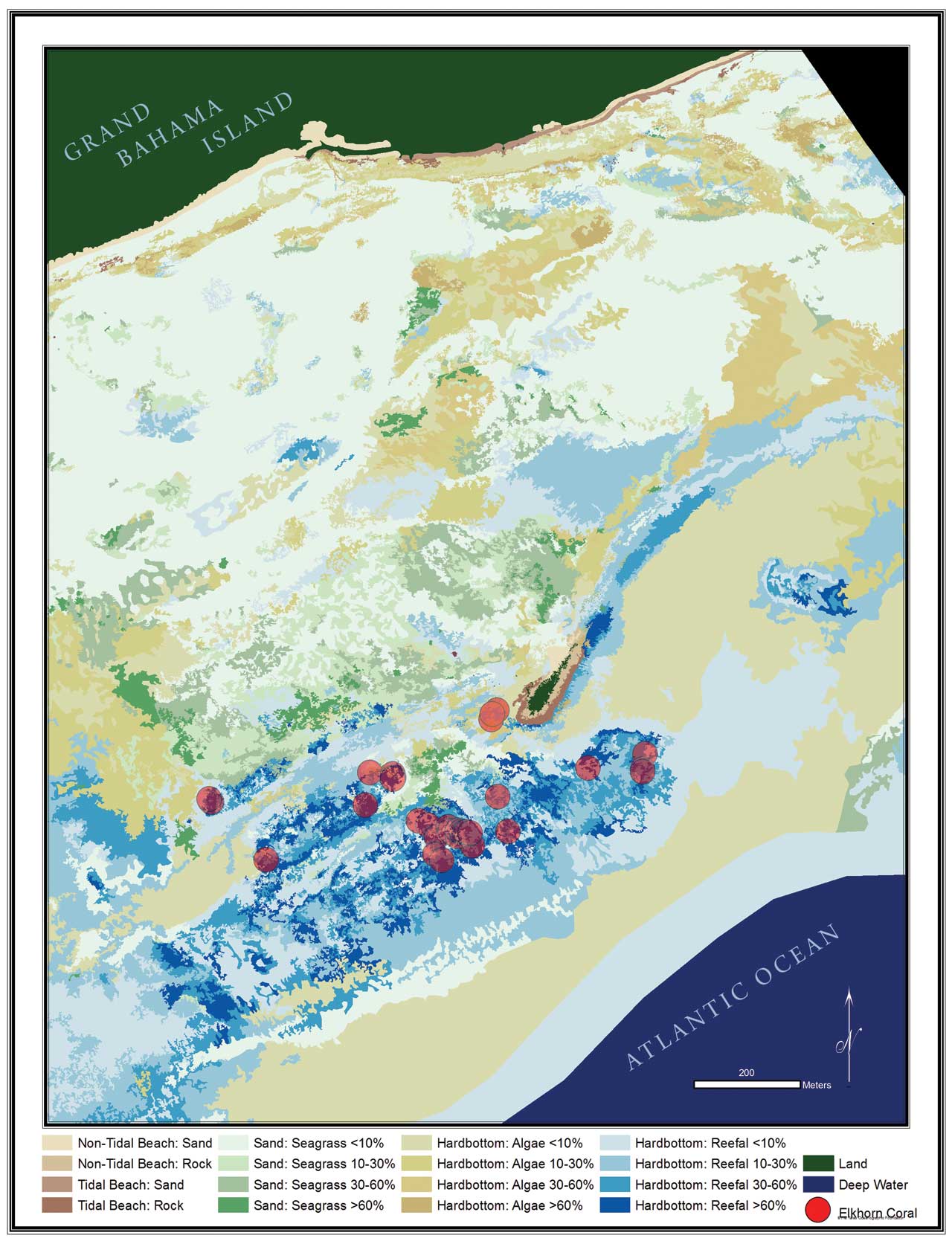
The first full fledged coral mapping project carried out in the Bahama archipelago has resulted in a highly precise map of the marine area that identifies different habitat types and locates individual species. Considered among the most complex and diverse environments on earth, coral reefs play a key role in the health of our planet's oceans. Pollutants, algae blooms, overfishing, damage due to development, and mooring are well-known threats to the health of reefs. Recent changes in the global climate are causing additional stresses including a rise in water temperature and acidity. The result is further decimation of existing reefs and the creatures that live in them and underpin the ocean's food web. Most knowledge of coral reefs and benthic habitats is based on monitoring data gathered through a range of methods, mostly reef surveys, varying from rapid monitoring by trained volunteers to highly detailed, species-level observations. [Benthic refers to the ecological region that is at the lowest level of a body of water.] However, these surveys provide little, if any, information on adjacent benthic habitats, such as sea grass beds or hard bottom, and, more importantly, fail to appropriately address and document the spatial component of the marine ecosystem. While coral reef mapping in itself is not new, most of these maps may differentiate shallow from mixed reef areas, but they do not provide further detail nor do they include adjacent areas of sea grass beds or other benthic habitats. Caring for coral reefs is dependent on knowing far more about these extraordinary benthic environments, the associated ecosystems they host, and the establishment of baseline data against which future assessments of ocean health can be measured. With these goals in mind, the Taras Oceanographic Foundation has embarked on a multiyear program to generate highly accurate maps of coral reefs that will set a new standard in the field of marine science and provide an invaluable tool for the monitoring, management, and preservation of these fragile environments worldwide.
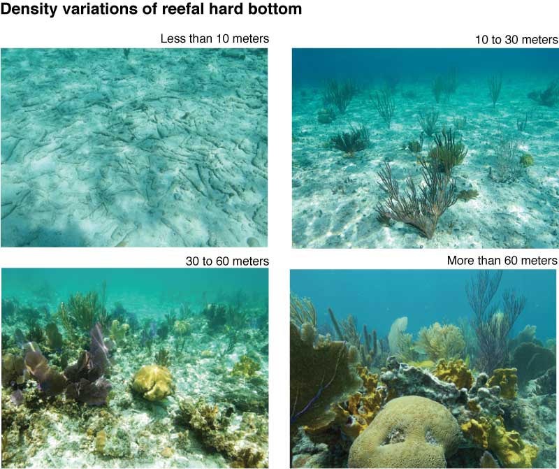
After refining analytical skills and ground-truthing methodology over the last two years, the foundation chose the coral reef adjacent to Peterson Cay National Park off the southern shore of Grand Bahama Island as the site for the first full-fledged coral mapping project. The site was selected because the coral reefs of the Bahama archipelago are in a near-crisis situation, like many other coral reefs around the world. Mapping this reef complex provides tangible benefits to those responsible for managing the marine resources. In addition, the reef complex was large enough to be significant, yet small enough to be charted in the available time. The reef map of Peterson Cay integrates aerial and satellite imagery with GPS data and onsite field surveys in ArcGIS. Spatial information was combined with the marine habitat classification framework defined by the Ecological Society of America (ESA) and the National Oceanic and Atmospheric Administration (NOAA) Office of Habitat Conservation. This framework provides for the distinction of community types and density variations therein. The delineation of these benthic community types resulted in a highly precise map of the marine area surrounding Peterson Cay. The map distinguishes between different habitat types that range from bare ocean floor to algae, sea grass, and coral reef and highlights density variations in each type. The map also pinpoints the exact location of individual species of interest such as the endangered elkhorn coral. Furthermore, with ArcGIS, it was possible to determine with impressive precision the spatial expansion of each marine habitat across the study site. The coral reef, in its various expressions of density, covers 208 acres, and the sandy bottom—with various degrees of sea grass, spreads out over 263 acres. Areas of hard pad with algae (generally red and brown algae) covers 209 acres, although the density of algae coverage in two-thirds of these areas is less than 10 percent. The ability to accurately locate individual corals or territorial fish species is essential for successful management and conservation programs. For instance, observations of the invasive Indo-Pacific lionfish (Pterois volitans), which poses a significant risk to native species, can be charted on the map, facilitating its capture and eradication. Having a visual representation of the entire reef, or a number of reefs stretched out across a larger area, is the best means of determining where to install fixed monitoring devices such as sedimentation traps. The comprehensive understanding of spatial features across the reef will also facilitate the identification of additional dive sites suitable for commercial scuba operators. Increasing the number of dive sites will alleviate the pressure on those currently used every day by multiple groups. Marking mooring sites adjacent to shallow reefs will help avoid reef damage caused by boat traffic and anchors. Last, but not least, knowing the exact location, dimensions, and composition of the reefs will help develop sustainable land-use plans for coastal projects so they can benefit from these natural jewels rather than harming or destroying them. By documenting the actual environmental conditions, the relationship between different habitat types and the larger reef ecosystem is better understood. In addition, it will monitor the expansion or decline of certain habitats. Conducting similar studies on adjacent reefs will eventually lead to a larger-scale map and a deeper understanding of both local and regional reef ecosystems and their processes. Although this new mapping technology doesn't necessarily represent the natural state of any ecosystem, it can at least provide a baseline against which we can compare future observations, thus establishing a powerful framework for conservation and management. And that's what the map of Peterson Cay's coral reef will do. By combining traditional observational recordings with precise spatial information, it provides new insight into the fascinating world just below the water's surface. For more information, contact Barbara Brunnick at brunnick@taras.org or Stefan Harzen at harzen@taras.org. AcknowledgmentsThe authors thank the entire expedition team, especially Lieutenant (Navy) Joseph Frey, as well as Michael T. Braynen, director of the Department of Marine Resources, for granting the research permit. This expedition would not have been possible without the support of Graham Torode, president and CEO of the Grand Bahama Development Company, who hosted the expedition and underwrote all of the expedition's finances. Thanks also go to the shareholders of Grand Bahama Port Authority, Limited (GBPA), and Grand Bahama Development Company (GB Devco) and especially to Sir Jack Hayward. Additional support came from Linda Osborne of International Underwater Explorers Society Ltd. (UNEXSO); Nakira Wilchcombe, environmental manager of the Grand Bahama Port Authority; and the Ministry of Tourism. About the Authors
Barbara Brunnick serves as the director of the Research and Conservation Program of the Taras Oceanographic Foundation. She is well known for her groundbreaking research on Atlantic spotted dolphins in the Bahamas and her instrumental role in pioneering the use of georectified maps in conservation of marine and wetland habitats throughout the Bahama archipelago. Brunnick holds a doctorate in biology from Union Institute & University, Cincinnati, Ohio. Stefan Harzen is a scientist, consultant, and entrepreneur who serves as the executive director of Blue Dolphin Research and Consulting, Inc., a distinguished science consulting firm working at the frontier of sustainability. Harzen's expertise includes marine mammals, coral reefs, and wetlands as well as natural resource management and sustainable business practices. He holds a doctorate in natural sciences from the University of Bielefeld, Germany. Brunnick and Harzen, a husband and wife team, have been included in Adventurous Dreams, Adventurous Lives, a Who's Who of international exploration. For more information on this topic, visit www.esri.com/training to learn more about Creating and Integrating Data for Natural Resource Applications, a Web course. |