Summer 2009
Summer 2009 |
||||||||
|
|
||||||||
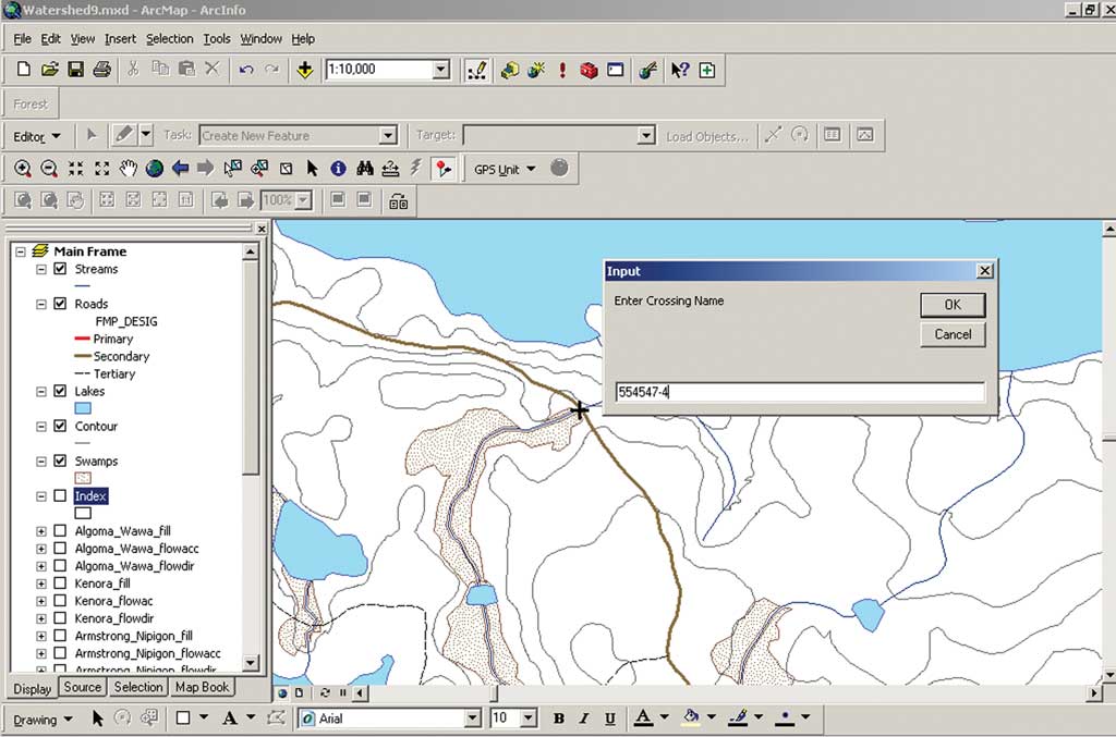
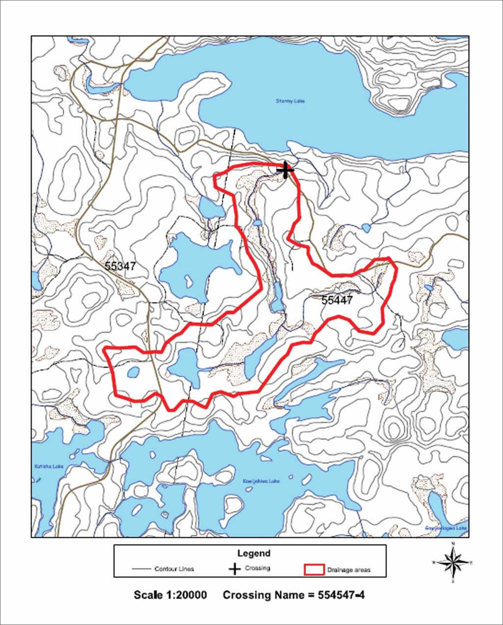
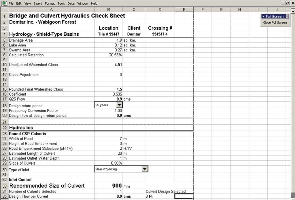
Domtar Corporation is the largest integrated producer of uncoated freesheet paper and one of the largest manufacturers of paper-grade market pulp in North America. [Freesheet paper does not contain groundwood pulp and is a brighter white than paper made from groundwood.] The company also operates Domtar Distribution Group, an extensive network of strategically located paper distribution facilities. The company also owns and manages more than half of the 15 million hectares of forestlands located in the province of Ontario, Canada. Accessing forest resources in northern Ontario quite often necessitates building access roads and crossings for the many streams common in these areas—an expensive undertaking. Building stream crossings requires in-depth planning to determine the proper type of crossing (e.g., culvert or bridge) and proper size of crossing to be installed. Prior to using GIS, forest operations staff members determined the drainage basin associated with each corresponding water crossing based on 1:50,000-scale maps. They used a dot grid overlay to determine the area of each corresponding drainage basin and associated area of lakes and swamps. This information was used with a formula that determined the proper size and type of crossing. Next, they produced a paper map showing the location of the proposed water crossing and its associated drainage basin to accompany the required paperwork. Depending on the location of a water crossing, the size of the drainage basin, and the experience of the person doing the calculations, it took one to several hours to complete calculations. Domtar set out to improve the accuracy and timeliness of its road building activities by using GIS as a framework. The company created an application using both ArcObjects and the ArcGIS Spatial Analyst extension that automates the process of performing water crossing calculations. A proposed crossing location is identified by clicking on a map, and the application determines the associated drainage basin by analyzing raster layer data from Ontario Ministry of Natural Resources (OMNR). This layer includes hydrologically corrected digital elevation models (DEM) data, flow accumulation, and flow direction along with Domtar's forest resources data. The resulting information is used to populate a Microsoft Excel spreadsheet that is used to predict crossing type and size. A page layout in ArcMap is exported as a PDF. Shapefiles of drainage basins and crossing location results can also be produced for future analysis.
The core users of the application are forest operations staff. They access the application through the ArcMap interface to identify proposed crossing locations. The results of their analyses are packaged up and submitted to OMNR for approval on an annual basis. Using GIS as a framework, forest companies are required to submit all operations information by December 31 to obtain approval to continue operations for the following fiscal year, which begins on April 1. OMNR considers this information when deciding to grant approval for the construction of roads and harvesting of resources. The ministry also examines ways to safeguard forest areas against the negative impacts of roads, both in terms of creating increased access and contributing to forest fragmentation. "Our water crossing analysis application has streamlined the approval process," said Paul Tremblay, manager of Information Technology at Domtar Corporation. "The Ontario Ministry of Natural Resources now receives a standard, computer-generated package for each water crossing application from the various Domtar locations across Ontario." The process of determining the most suitable drainage basin and associated water crossing is now completed much more accurately. Using GIS in conjunction with the water crossing application, Domtar has been able to capture data at a scale of 1:20,000 or better. The company has also been able to quickly test different scenarios when identifying preferred crossing locations. Often, there are several possible locations for every proposed major road. GIS helps analysts consider factors such as topography, geology, and proximity to harvest blocks. The water crossing tool allows them to easily check what culvert sizes are required at each location. This allows better planning and helps construct roads more effectively and has significantly reduced operating costs by allowing the selection of smaller water crossings when building forest access roads. During two years of use, the application has undergone a number of improvements. Calculations for each water crossing now take as little as 10 to 20 minutes to process. The old manual approach usually required about an hour to perform the same calculations. This represents a 75 percent increase in productivity. Another important benefit is the ability to perform calculations on multiple crossings using batch processing. The forester or forest technician clicks a button to start the process and then is free to perform other duties while the computer performs the calculations.
Other benefits include more consistent results, fewer errors, and greater productivity. When users were asked to interpret information on individual maps, they often found that results would vary from one person to the next. For example, the drawn outline of a drainage basin based on contour lines on a map often differed from one to another. Factors such as user experience and time of day (or day of the week) often affected the interpretation of information. (e.g., results from Monday's work differed from Friday's work). This automated process has reduced incorrect information that results from misinterpretation of drainage basins and/or calculations of retention areas (i.e., water bodies and swamps), and these calculations can be generated in minutes rather than hours. Future PlansEventually Domtar would like to provide this service to other forestry users by hosting the application on a GIS server and making it available via the Internet. The company expects the application will be popular with forestry companies in Ontario that use a manual approach to calculating water crossings. Although some forestry companies currently use GIS to assist in these calculations, they must manually digitize drainage basins and perform geoprocessing tasks that feed information into an Excel worksheet to determine appropriate culvert sizes. Because Domtar's application is fully automated, the company believes it can be applied to all forests in Ontario, regardless of who manages them. "We hope to make this tool available to other forest companies and are confident that it will increase their operational efficiencies and reduce costs while at the same time minimize their impact on fish habitat and water quality," said Tremblay. For more information, please contact Paul Tremblay, Information Technology, Domtar Corporation, at Paul.Tremblay@domtar.com or visit www.domtar.com. AcknowledgmentsTremblay acknowledges the work of Claude Joannette, business systems analyst at Domtar, in developing the tool and improving it over the years. "It's people like Claude that really make a difference to the continued success of this tool throughout our operations," said Tremblay. |