Summer 2009
Summer 2009 |
||||||||
|
|
||||||||
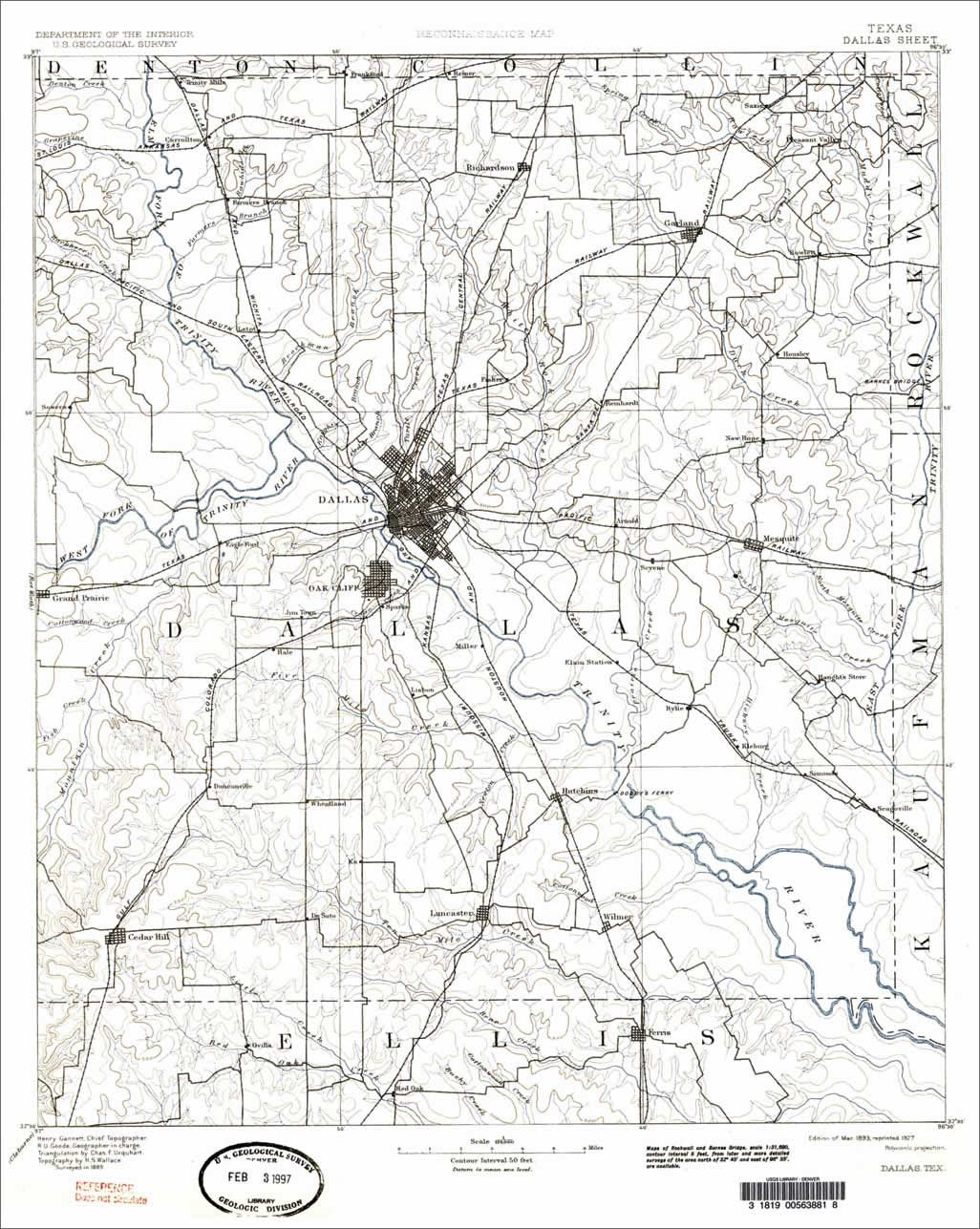
This article as a PDF . Texas Department of Transportation (TxDOT) created a GIS-based historic archaeological resource that helps avoid sensitive archaeological and cultural sites and guide field surveys. From the long-lost missions built during Spanish rule to the historic cattle drives along the Chisholm Trail, Texas geography tells a varied and diverse story that historians, archaeologists, and cultural resource experts are still trying to write. It's up to agencies like TxDOT to ensure history is preserved while keeping the current residents moving forward. Second in the nation in both size and population, Texas is home to 23 million people, and cars and trucks are the primary mode of transportation. Currently TxDOT maintains the public highways that crisscross the state's almost 270,000 square mile area. By 2020, road and rail freight moving to, from, and within Texas is expected to increase by 70 percent, while population is expected to increase 52 percent by 2030. In an effort to more effectively manage cultural resources affected by highway construction and maintenance, archaeologists and historians in TxDOT's Environmental Affairs Division teamed with PBS&J to create a GIS-based historic archaeological resource. The Texas Historic Overlay (THO) would provide important information needed for planning transportation improvements and maintenance projects. The source information for creating the GIS would be historic-era maps. Today, the THO is an integral part of TxDOT's efforts to preserve and protect valuable resources, along with almost 80,000 miles of state highways, while securing rights-of-way for highway widening and new alignments for the future. Historic Map CollectionThe THO project began with an effort to gather out-of-print historic maps with significant cultural detail that were created between 1722 and 1988. The effort focused on the eastern half of Texas, an area that comprises 62 counties covering 145,000 square miles. More than 3,000 historic maps exist for this area. Over a two-year period, the THO team solicited information from 162 libraries, museums, and repositories. Once the information was gathered, the team scanned, processed, georeferenced, and indexed these maps and incorporated them into a single system. Maps were supplied in a variety of formats including scanned hard copies, photographic reprints, microfilm, digital photography, and tracings of hard-copy maps on vellum. The map images were initially enhanced in Adobe Photoshop to adjust brightness and contrast, replace aged paper color with white, and remove any blemishes present on the maps. Bibliographic and other detailed information regarding source maps was captured in a Microsoft SQL Server database. Coordinated ConnectionsOne of the greatest challenges in the THO effort was georeferencing all maps to a common coordinate system. Unfortunately, most georeferencing software is designed to transform coordinates for U.S. maps that are created with the North American Datum of 1927 (NAD27) or more recent horizontal datums. Many maps selected for use in THO use a datum predating NAD27. Of the 3,318 source maps, 745 used an antiquated datum such as the North American Datum (1913), the U.S. Standard Datum (1901), or other datums available prior to development of regional geodetic datums. Most antiquated datums used by the historic maps selected for the project are actually a datums that use the Clarke 1866 ellipsoid. The exceptions to this generalization are the Walbeck 1820 ellipsoid and the Bessel 1841 ellipsoid. In 1870, the U.S. Coast Survey adopted the Clarke 1866 ellipsoid for use for geodetic purposes including mapping. This ellipsoid was used as a local datum until the adoption of the first geodetic datum of the United States, the U.S. Standard Datum of 1901. In 1913, the U.S. Standard Datum was renamed the North American Datum (NAD) with its adoption by Canada and Mexico. To transform a coordinate system to the selected common coordinate system, mapping experts developed three-parameter Molodensky transformations for each historic datum encountered. The process works by calculating the shift along the x-, y-, and z-axes from one system to another. To calculate this shift, the team undertook a substantial research effort to find coordinates for features represented in historic and modern form. Resource Ready
Completed in early 2007, the THO is integrated into TxDOT's existing statewide GIS, which is built on ArcGIS. All selected historic maps were georeferenced using vector registration overlays representing historic coordinate systems or geographic features with resulting images in GeoTIFF and MrSID formats. Once the maps were registered and resampled, PBS&J used the Positional Accuracy Assessment Generator (PAAG), an ArcObjects application created by PBS&J, to calculate the accuracy of the spatially referenced historic maps. Source map extents were digitized as polygons in geodatabase feature classes to serve as an index joined to the source map information in SQL Server. The team also created the Metadata Miner, another ArcObjects-based application, to automate the generation of historic map-image-specific metadata in Federal Geographic Data Committee (FGDC) format using information mined from a SQL Server database. The resource information developed from the THO project is available to TxDOT and approved consultants to develop historic trends in land use, development, and vegetation and manage the state's cultural resources while planning state road and highway projects. "Just about every project we do for TxDOT includes use of the Texas Historic Overlay in the early stages to identify likely locations for resources that once existed in the landscape," said Eugene Foster, senior scientist at PBS&J and project manager for the THO project. "We typically use that information early on to compare and refine project alternatives." The data is used to develop scopes and budgets for field surveys. It also guides historians and archeologists in field surveys and right-of-way acquisitions. For instance, PBS&J was contracted by TxDOT to evaluate the possibility of unmarked graves in the area surrounding a proposed bridge on State Highway 130 over State Highway 71 near Austin. PBS&J planners needed to survey about 15.7 acres of land located adjacent to the proposed bridge site. The team pulled area maps from THO to locate cemeteries. Then they overlaid remotely sensed data to find unmarked graves at the site. While no unmarked graves were located, the team was able to help TxDOT see the old State Highway 71 alignment as well as some potential historic sites. The entire site analysis took three days. Jim Abbott, project manager for the TxDOT Environmental Division, said, "The ability to access and compare historic maps at the desktop provides us with a powerful tool for cultural resource planning. With the Texas Historic Overlay, we can quickly and consistently locate and avoid possible historic archaeological sites that otherwise might be missed in planning for highway projects."
The resource proved particularly valuable to a project in San Antonio, Texas. As part of the redevelopment of downtown San Antonio, the city wanted to renovate the historic Main Plaza located about a mile from the Alamo [the site of the most famous battle of the Texas Revolution] into a pedestrian-friendly plaza for residents and the millions of tourists who visit annually. First established in 1731 by Spanish settlers as the Villa de San Fernando, the Main Plaza has always been the center of San Antonio's municipal government. Soldiers killed during the 1810�1820 War for Mexican Independence are buried at the church along with the remains of the defenders of the Alamo. The Main Plaza also links to the historic San Fernando Cathedral and the nearby San Antonio River. PBS&J used the THO geodatabase to identify and avoid sensitive archaeological and cultural resource sites during construction activities as mandated by the Antiquities Code of Texas. Historical consultants laud the new resource because of its value in projects like the renovation of San Antonio's Main Plaza. Abbott said, "They say it has saved them so much time because we've been able to gather these resources, which have heretofore been scattered all over the state and were not being used, and bring them into one place where they are readily accessible." THO data is available to TxDOT and approved consultants to manage the state's cultural resources and develop historic trends in land use, development, and vegetation. Although some maps are restricted as a result of agreements between TxDOT and the individual libraries and repositories that own the paper copies, the rest of the maps are available to the public through the Texas Natural Resource Information System Web site at www.tnris.org. About the AuthorTy Summerville is the geospatial project manager for PBS&J. He has more than 11 years of experience in this area. He can be reached at tdsummerville@pbsj.com. For More InformationUnderstanding Map Projections and Coordinate Systems and Georeferencing Rasters in ArcGIS, both Web courses, are available from www.esri.com/training. |