Evaluating Alternatives for Restoring the Everglades
By Ken Rutchey and Dewey Worth
South Florida Water Management District

| Evaluating Alternatives for Restoring the Everglades By Ken Rutchey and Dewey Worth | |
|
Editor's note: Congress passed the Everglades National Park Protection and Expansion Act in 1989. This legislation added 107,000 acres to the eastern border of the park and required that the U.S. Army Corps of Engineers (USACE) restore the natural hydrological conditions of North East Shark River Slough, an area added to the park by the act. The South Florida Water Management District (SFWMD), one of the government agencies affected by the act, is using ArcInfo with the ArcGrid extension to evaluate alternative plans for modified water delivery to the park. The SFWMD, an agency of the State of Florida, represents the water interests of south Florida. Modifying water delivery to the Everglades National Park cannot proceed until various alternatives are considered that would mitigate the risk of flooding to some or all of a sparsely populated agricultural community located on the eastern fringe of the Everglades known as the 8.5 Square Mile Area (SMA).
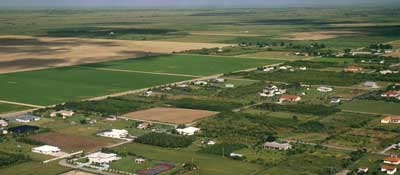
This small community is located west of a protective levee system designed to contain the Everglades and prevent floodwaters in the Everglades from flowing eastward into the urban areas of Miami–Dade County. Due to its proximity to the Everglades, low topography, and lack of drainage, the 8.5 SMA frequently floods for several months during each rainy season. Restoration of the Everglades National Park would exacerbate the flooding conditions without some remedy. In 1989, Congress directed the USACE to develop a flood protection system compatible with the hydrologic restoration needs of the park. For more than 10 years, federal, state, and local agencies have tried to develop an acceptable plan. In July 1999, the SFWMD requested that the USACE formally develop and evaluate a full array of alternatives that would provide flood mitigation for the 8.5 SMA. Modeling AlternativesThe complex interactions between surface water and groundwater flows and drainage canals required a three-dimensional modeling approach to evaluate the potential flood protection alternatives. The MODBRANCH hydrological model was adapted for use on data from south Florida. Data inputs to the model included topography, hydrogeology, rainfall, evapotranspiration, water sources, water sinks, and behavior of various canal structures. Grid resolution of the model varies. Along the east-west axis it ranges from 431 to 10,560 feet, and along the north-south axis it is between 673 and 10,560 feet. The width of each row or column is determined by the resolution required for specific areas.
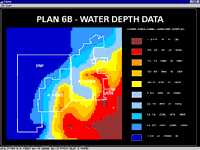
Evaluating alternatives required computing more than 80 separate model runs. To investigate the effects of flood and drought conditions, data from two wet and dry precipitation years were used as model input. A base condition, approximating current conditions, was modeled for comparison to these extreme conditions. Each model alternative generated an enormous amount of data. This data, compiled into Microsoft Excel spreadsheets, included weekly stage data for each of the 8,172 grid cells. Ground elevations for each of the grid cells were subtracted from the stage data, providing weekly water depths for each of the grid cells. Creating a Tool for Analyzing OutputThe SFWMD was evaluating data independently of other agencies and needed a tool for quickly viewing and analyzing the model output for each alternative in a spatial context that could be easily quantified. The evaluation needed to include the effects each alternative had on the land recently added to the park. In addition, the tool used to evaluate these alternatives should be able to quantify effects on predefined areas and depth ranges for the entire study area or selected portions of it. Consequently, the tool should allow the user to adjust the spatial extent. After considering a number of options, an ARC Macro Language (AML) program was developed that meets these requirements. Because the AML was based on TOPOGRID, an ArcInfo command, it was named TOPOGRID.AML. The TOPOGRID command utilizes a robust interpolation method designed specifically for the creation of digital elevation models and was particularly suited for this project because it allows user-selected boundary extents. The user can also set drainage boundary conditions so that the elevation model can take into account abrupt changes in the terrain caused by the canals located within the project area.
Initially an ArcInfo point coverage was created using the model XY grid cell locations, and the ITEMS needed for importing the model grid data were defined. Pertinent model data contained in the spreadsheets was exported to ASCII text files and then imported as a point coverage. Boundary coverage files that defined the desired study and three subregions were also created. Classification ranges and associated code values for depth and stage data were established by using ArcInfo lookup tables. When run, TOPOGRID.AML begins by prompting the user for the coverage file name for the data, the ITEM name containing the data within the input coverage, the output file name, and a boundary coverage file name if the data is depth or stage data and up to three subregion boundary coverage files. In this case, the three subregions included a portion of Everglades National Park, the 8.5 SMA, and the adjacent agricultural lands. Once the initial data requests are entered, TOPOGRID.AML initiates the ArcInfo TOPOGRID command, which takes the input point coverage data and creates a grid coverage within the boundary coverage extent. The LATTICEPOLY command then converts the grid coverage into a polygon coverage based on predefined stage and depth ranges set up as INFO data files. The AML uses the subregion boundary files to calculate the area within the predefined stage and depth ranges for each subregion. Last, the AML initiates an ArcPlot session and all data is plotted to the screen. The user is prompted for a title before a final ArcInfo graphics file is created. ConclusionThis AML was useful in evaluating numerous Everglades restoration alternatives both graphically and quantitatively in a timely manner. It lets the user select different geographic extents and subbasin boundaries and allows for easy viewing and quick analysis of key areas. The TOPOGRID.AML was designed to be generic. Because the ArcInfo TOPOGRID command has many subcommands and options, TOPOGRID.AML can be easily modified for use with other applications requiring topological interpretation. The application of GIS technologies in this particular project provided a quick and direct means for water managers to interpret the spatial significance of hydrologic model simulations on water resources. This provided valuable feedback that helped them validate that iterative changes in model simulations were producing the desired effects and evaluate the trade-offs associated with each modification. Adaptation of the model data in GIS further allowed manipulations and overlays of other spatial data to more fully evaluate the hydrologic context and potential impacts on adjoining areas. Future analysis and assessment using GIS will include evaluations of topography and land recontouring to reclaim wetlands. For more information, please contact About the AuthorsKen Rutchey, a senior environmental scientist with SFWMD, holds a bachelor's degree in biology with a minor in chemistry from Palm Beach Atlantic College. With SFWMD since 1981, he has worked specifically on Everglades-related research and is interested in using remote sensing and GIS for evaluating restoration alternatives for the Everglades ecosystem. Dewey Worth, a lead environmental scientist, received a bachelor's degree in zoology and completed graduate studies in aquatic ecology at the University of South Florida. He has done research in wetlands ecology, remote sensing/GIS applications for environmental and landscape monitoring, and water quality modeling of lakes and reservoirs. |