A Powerful Tool for Land Records—ArcScan for ArcGIS
 |
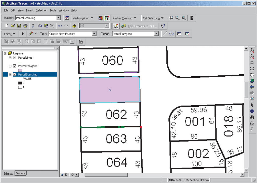
| The Vectorization Trace tool creates polygon features from raster data by following along the middle or centerline of a series of connected raster cells. |
Users with parcel maps and plotted survey locations that must be converted to vector datasets will benefit from the release of ArcGIS 8.3, particularly the ArcScan for ArcGIS extension. Having tools that streamline the conversion process is crucial for organizations that maintain parcel data. ArcGIS 8.3 makes this process possible without requiring the use of multiple software environments to perform both raster cleanup and data conversion.
The ArcScan for ArcGIS extension lets users create vector features from raster data interactively or with the help of automated tools. This process, known as vectorization, generates features that can be stored as shapefiles or in geodatabase feature classes. The snapping environment, interactive vector tracing, batch vectorization, raster selection, and cleanup tools in ArcScan provide all the functionality needed to convert raster datasets to vector features.
By simply starting an editing session and using the ArcScan tools with spatial adjustment and topology tools in ArcGIS 8.3, users can vectorize features from raster images, transform new vector data into the correct coordinate system, and create polygon topology.
Raster Selection and Cleanup
ArcScan's raster cleanup process uses interactive and expression-based cell selection, which makes feature generation more efficient. A box can interactively be dragged to select connected raster cells and, by holding down the Shift key, unconnected cells can be deselected. Optionally, selections can be based on the foreground and background raster cells. The expression-based selection dialog, used to control the connected cell size area and diagonal length, is primarily used for deleting noise. Selections can be used with other ArcScan commands such as Erase Selected Cells or Fill Selected Cells.
Raster painting functions perform simple edits on raster datasets. The brush, fill, draw, and erase tools that are commonly found in other raster editing packages are available from the Raster Painting toolbar. These tools enhance productivity. For example, the Magic Erase tool deletes a set of connected cells on a raster without requiring manual selection.
Raster Snapping
New snapping options for tracing along rasters permit feature creation relative to cells and other objects in the database, which results in more accurately vectorized datasets. These new options include snapping to centerlines, corners, intersections, ends, and center points or solids of raster cells. Snapping can be restricted to cells that meet raster line width requirements.
Raster Tracing
Raster tracing is used when vectorization is performed on defined areas of a raster. In conjunction with the raster snapping environment, tracing vector features along raster lines provides full control over feature creation in isolated sections of a dataset. Although raster tracing with snapping options is primarily used to create features, editing functions can also be used in combination with these ArcScan tools.
Batch Vectorization
Batch vectorization automatically generates features as shapefiles or geodatabase feature classes against an entire dataset or a selected set of raster cells. Results vary depending on the amount of data cleanup (i.e., preprocessing) performed prior to vectorization. Raster cleanup tools can remove unnecessary data such as annotation within a parcel boundary, notes written on a map, or small amounts of raster noise left over from the scanning process.
In addition to preprocessing raster data, the vectorization settings will strongly influence how features will be created. These settings control how intersections are generated, the frequency of vertices used when creating line features, and gap closure between areas with no data. Once calculated, these settings can be saved for later use as a raster style or in the map document.
Adjusting and Attributing Data
Features derived from raster data using ArcScan can be transformed, rubber sheeted, and edge-matched into the correct coordinate space and joined to existing features using the spatial adjustment tools in ArcMap. Displacement links are graphic elements that are used to define source and destination coordinates when spatially adjusting features. The point locations used for creating displacement links can be derived from one or a combination of methods such as snapping to background imagery or loading point location data from survey observations. The Attribute Transfer Mapping functions support interactive transfer of attributes between features by setting source and target layers and specifying which fields to use for attribute transfer.
Creating Polygons From Vectors
Polygons can be generated from features vectorized in ArcScan using several methods. The Sketch tool in the Editor toolbar, with appropriate raster snapping settings, can be used to trace vectors by snapping to centerlines, intersections, ends, and solids to create polygon features. The Vectorization Trace tool in the ArcScan toolbar, also used in conjunction with the raster snapping environment, can create polygon features from raster data by following along the middle or centerline of a series of connected raster cells.
Integrated Tools for Parcel Maintenance
The ArcScan for ArcGIS extension streamlines the process of vectorizing raster data, such as plat maps, so that it can be used for analysis with other vector datasets and maintained in a geodatabase. This extension works with ArcGIS 8.3 core tools for making spatial adjustments and creating topology. For more information on how to use the ArcScan for ArcGIS extension, please refer to the online help or visit www.esri.com/arcgisxtensions.
|