July - September 2003
July - September 2003 |
||||||||
|
|
||||||||
Using current aerial photographs as a base layer, a GIS technical specialist can display structures, roads, and fuel breaks that are near the fire. This information can be critical to firefighters who are not familiar with the area. Aerial photographs give firefighters an aerial view of the terrain without having to get into an aircraft. This information can be extremely useful in determining which structures are threatened or where roads, fuel breaks, and other features that can assist in control of the fire are located. Layers that show vegetation, or fuels (i.e., vegetation classified by fire behavior attributes), can be displayed with a fire's perimeter to help firefighters determine where to expect different types of fire behavior. Digital elevation models (DEMs) show firefighters slopes and aspects that can affect fire behavior. This type of information can alert firefighters to areas of concern. Fuels, slopes, and aspects are some of the most critical factors that influence the behavior of a wildfire. Being able to display a topographic map or an aerial photograph as a base layer can assist firefighters by allowing them to see what's over that next ridge or areas that they are not able to see. What It TakesThe experience of GIS technical specialists is perhaps the most crucial factor for the success of Initial Attack GIS. The best equipment means nothing without well-trained and highly skilled GIS users. For the LACFD GIS teams, training starts with FIRESCOPE's GIS Technical Specialist training. During this training, GIS technical specialists learn to adapt GIS to the fire fighting world. Ventura Tools is one of the many extensions that must be mastered to produce maps under severe time crunches. This training helps GIS technical specialists perform GIS on fires and other risk incidents that require a spatial component.
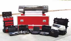
Although most GIS technical specialists are called in after the initial attack phases when the time frame to produce a map is more generous, Initial Attack GIS technical specialists operate in a completely different environment. Time is of the essence. A map must be produced within an extremely short time period, and GIS technical specialists must troubleshoot software and hardware issues while dealing with a raging brushfire. Currently there is no official training offered to GIS users in the techniques and procedures of Initial Attack GIS. Consequently, most GIS technical specialists gain experience and knowledge while actually working in an Initial Attack situation. LACFD holds training sessions periodically to drill GIS teams in producing various map products under pressure. These GIS teams, made up of two technical specialists on a one-week rotation, are ready to respond to any emergency 24 hours a day. Team members are GIS users from the Forestry and Information Management Divisions of LACFD. Overcoming the ElementsOne of the biggest challenges in making Initial Attack GIS work is making it mobile and rugged. Most Initial Attack GIS assignments are in the roughest conditions. LACFD has constructed kits that enable the GIS teams to take GIS equipment out of the office and into the wildfire environment. With the use of power inverters, powerful laptop computers, and various portable devices packed into ruggedized cases, GIS technical specialists can turn any vehicle into a mobile GIS unit. All equipment is protected in padded cases that can withstand the brutal driving conditions on dirt roads and exposure to smoke, ash, and dust. LACFD helped design a custom-made box for the Hewlett-Packard 1055 plotter that lets GIS technical specialists print large maps. Special water- and tear-proof paper is used for the maps that are sent out with the firefighters into the field. Both Ventura and Kern County Fire Departments have converted passenger vans into mobile GIS units, which allow them to respond to emergencies as an initial attack resource. Although a designated mobile GIS unit is preferred, this is not necessary to start an Initial Attack GIS program. The Future of Initial Attack GISInitial Attack GIS is here to stay. The beauty of GIS is that various types of information can be displayed with the fire's perimeter. As spatial information becomes more accurate and readily available and the need for it is appreciated, Initial Attack GIS capability will become widely accepted. LACFD has responded to the need for more accurate spatial information by developing an infrared (IR) camera/mapping system that is compatible with GIS. The system incorporates AeroNavitraker, navigation system software from Navitrak International Corporation that provides a moving map display, with a submeter differential GPS unit linked to a Wescam 16DS camera in a Bell 206 helicopter. This new platform enables IR camera operators to map fire perimeters through the camera's ground intercept point (GRIP) as opposed to the aircraft position when flying directly over the fire line. This allows IR camera operators to accurately map the fire line through smoke while operating at a safe distance from both the fire and other fire fighting aircraft. AeroNavitraker software can export the fire line as a shapefile. This new system will be initially used during the 2003 fire season to provide GIS technical specialists with real-time, reliable, and accurate fire line data. GIS, with its ability to display various spatial data, is another tool that can assist firefighters in making more informed decisions. However, its use is not limited to wildfires. Initial Attack GIS can be applied to almost any all-risk incident-search and rescues, floods, or earthquakes-that can benefit from rapidly delivered spatial information that can aid rescue efforts. Technologies, such as GIS, continue to be incorporated into the fire service and provide support for decision makers. As these tools gain acceptance, they will not only help make critical decisions but also assist in saving lives and property. For more information, contact Lyle Koegler For information about FIRESCOPE and the GIS Technical Specialist training, visit the GIS FIRESCOPE Web site at maps.oes.ca.gov/GISTech. |