Creating a Modern Land Records System
As part of its Public Sector Modernisation Programme, the Jamaican government combined several core land records functions that had previously been managed separately—land title, survey and mapping, land valuation, and estate management—into one agency, the National Land Agency (NLA).
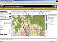 |
| eLandjamaica is a Web-based system that provides a point of access for all land-related issues in Jamaica. |
Established in 2001, NLA is part of Jamaica's plan to create a modern national land information system and enable sustainable development. Improving service to the public is one of NLA's major goals. Streamlining and automating processes, such as title transfers, and centralizing access to NLA services and making them accessible online and throughout Jamaica are some of the strategies NLA has pursued. NLA is working to build a spatial information infrastructure that will enable private sector organizations as well as government agencies at all levels to share land and marine data.
Initially, NLA administrators had to wrestle with various nonintegrated systems. Consolidating the multiple databases and document management systems that NLA inherited from the four original agencies was a formidable task. In addition to integrating databases into a cohesive manageable system, NLA had other requirements for a system that would serve the new agency. These requirements included
- Single-window access—An integrated, easy-to-use Web interface should combine all land-related information (e.g., existing data, scanned documents, and plans) and make these underlying data systems completely transparent to the user while allowing administrators to maintain data in the original systems.
- Combine nonspatial and spatial functionality—Users should be able to search using both traditional attribute and visual map-based queries.
- Integrated document viewer—The interface should include a document viewer that allows users to look at online documents such as title deeds and plans.
- Electronic commerce—The NLA needed a system that could charge users based on the type and quantity of information retrieved, provide a user with an exact quote before showing the results of a query, and log charges for administrative purposes.
- Administration tool—Most important, nonsystem personnel should be able to manage the system.
In April 2002, Orion Technology Inc., of Richmond Hill, Ontario, a business partner of both Esri and Esri Canada, won an international tender to provide the NLA with a streamlined and integrated system. This Web-based system would be the point of access for all land-related issues in Jamaica. After performing a requirements study and analysis of existing NLA systems and processes, Orion and NLA developed a requirements baseline. Orion developed and revised prototypes based on interaction with stakeholders.
This process included walk-throughs to confirm that business logic was understood by the consultant. The functionality proposed required implementation of a multilevel and extensible subscription and payment model to meet the needs of internal and external clients. A data model that integrated the data from the original systems and created appropriate links between spatial and nonspatial data was developed. An intelligent customer feedback module was required so that users could provide NLA with information about any data gaps or inconsistencies. Processes were also needed to allow for continual automated data updates with minimal user intervention and zero application downtime for both Internet and Intranet versions of the Web site. In addition to implementing the system, NLA staff had to be trained.
Orion leveraged its extensive GIS experience and skills in Java- and Oracle-based Internet application development to deliver the eLandjamaica system to NLA in early 2003. In addition to fully meeting the NLA requirements and complying with the Java 2 platform, Enterprise Edition (J2EE) standard, eLandjamaica allows NLA staff to customize the service offerings and application appearance based on marketing realities and client feedback without resorting to code changes. Streamlining business processes has improved the overall level of service. Automating NLA functions has reduced the time it takes to perform land-related queries and tasks. Because it is Internet-based, eLandjamaica lets the public access NLA services from any region in Jamaica. The forms needed to do business with NLA are readily available online. In addition, NLA can share land-related data with other government agencies and private-sector organizations through this online infrastructure.
Different services are available from eLandjamaica. These services include basic property search, advanced property search, sales search, and interactive map and survey monument search. Basic property search is available at no cost to anyone who needs to find the NLA Valuation Number assigned to a specific parcel or wants to obtain the Volume and Folio Number for a registered parcel using the Valuation Number. Advanced property searches let subscribed customers view and print information from the land valuation and land titles databases and search using a variety of parameters.
An interactive GIS-based map at the site allows users to locate districts and identify the general location of properties. A map of any area can be printed showing topographic features such as roads and vegetation. Data on survey monuments can be searched based on ID numbers or located interactively on a 1:12,500-scale topographic basemap. Additional enhancements, such as sales reports, title caveats, valuation roll information, and topographic and planimetric maps, are planned for future release.
A week of ceremonies and activities in January 2003 celebrated the success of NLA and the launch of eLandjamaica. According to Garfield Knight, the Director of Information Technology for NLA, "The Orion team has been partners in its true sense as they worked with our specific needs and constraints while still ensuring that the project objectives were never compromised. The ease of use, flexibility, and advanced technological framework of the Orion solution will ensure that this investment not only serves our immediate needs of delivering spatial information over the Internet but will be developed in the future to offer additional services to our customers."
|
