Managing Land Records in New Mexico
A GIS-based solution developed by Esri and Redlands, California-based Esri business partner GIS Technology, Inc. (GTI), is helping the New Mexico State Land Office (SLO) and newly elected Commissioner of Public Lands Patrick H. Lyons manage nine million acres of surface and 13 million acres of subsurface land scattered across 32 of New Mexico's 33 counties.
The Hundred-Year-Old Paper Trail
SLO is a land trust. By 1910, trust lands, amounting to approximately 12 percent of the state's land, were granted to New Mexico by United States Congress. These lands were to be administered for the benefit of public institutions, primarily public schools. Since it began marketing and managing trust lands, SLO has dealt with the millions of lease and title records that have been generated and ever-growing demands to fairly and efficiently serve the needs of the general public, trust beneficiaries, and lessees of public lands.
 |
| With integrated access to all data sources, there is no longer any penalty for not knowing if the information needed is in a table or a document. |
From its earliest days, SLO adopted a system for organizing lease and title records based on the public land survey grid. Paper ledgers, called tract books, record all lease transactions and title documents by town, range, and section (TRS). When a lease is created, assigned, expired, or acted on in any way, entries are made in every tract book containing some part of the leased property. The tract book entries refer to paper documents that are stored in folders.
Beginning in the early 1990s, SLO began supplementing the paper-based records system with a database application written in DB2 called ONGARD. The database preserves the TRS indexing scheme that originated with the paper system.
A Burdensome System
Although the paper-based system is logical and was appropriate when it was designed, it imposes many burdens. Duplicate records must be posted in the tract books, often on many different pages, as well as entered in ONGARD. The growing number of paper records poses an ongoing storage and security challenge. Maintaining the physical integrity of the records and restricting access to authorized personnel are concerns because, although most of the records are public information, some are not.
More important, staff often find it difficult to access the information they need to do their jobs. For example, an SLO employee who receives a request to modify something about a lease has to research the tract books and/or ONGARD to identify the needed information. This research might require looking through many pages of many tract books before going to the files to check out the actual documents. These documents might remain checked out to a staff member for months while the request is being completed.
Developers were also limited by the system because there was no method for quickly searching for trust properties with specific spatial characteristics such as proximity to paved roads or a particular type of soil. Information on public records required a trip to the Santa Fe office or a special request for records, which entailed retrieval and copying fees and delay while the request was processed and mailed. While the Land Office employee processing such a request can find information about a specific property, that information doesn't provide any spatial context, so determining proximity to features such as roads was difficult.
GIS-Enabled Solution
To meet its need for efficient information storage and management, coupled with improved access to data, SLO turned to Esri and GTI for a solution. The key technology components delivered by the Esri/GTI team include Esri's ArcGIS and ArcView 3 and FileNET's Panagon Document Management System (DMS).
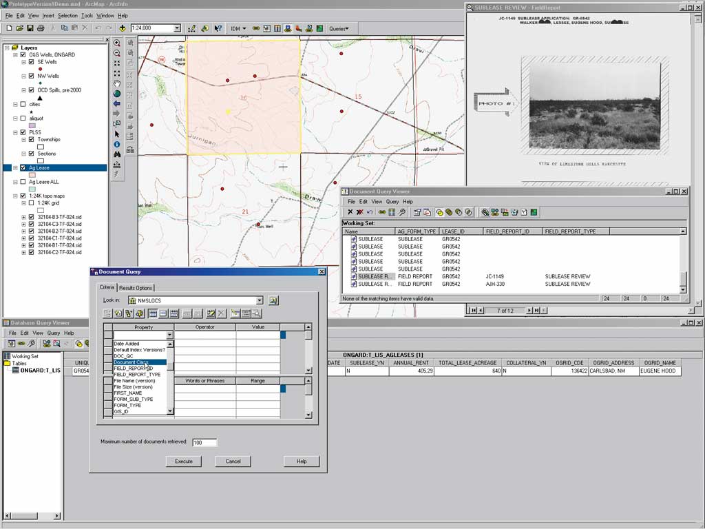
The DMS solves the document storage and retrieval problems. Scanned paper records and electronic documents, such as reports and correspondence, are secured in the Panagon document repository with appropriate access limitations. Staff members with necessary authorization can retrieve documents from anywhere on the network or the Internet. Documents can be annotated and redacted, subject to authorization constraints. The document annotation capability provides a mechanism for preserving "institutional memory" about state lands. When documents are added to the system, document metadata is also added that enables query-based document retrieval.
Instead of tediously searching ONGARD and the tract books, users can now access lease and title information directly through ArcView and ArcMap displays. In addition to greatly improving access to information, GIS enhances decision making by providing the critical spatial context for state-owned lands.
Querying From Any Source
GTI provided the means to combine GIS with the document repository and with tabular information drawn from the ONGARD system, enabling users to query all three information sources in an integrated fashion. For example, an SLO employee searching for available grazing land near currently leased property can retrieve lease documents from the DMS and create a map display that shows the lease boundary and surrounding area with a single menu pick. After using GIS to select other nearby properties, the employee can link back to the DMS and ONGARD tables to determine the availability of the selected lands.
A query can start in GIS, DMS, or ONGARD, and that selection can be used as a key to retrieve information from the other systems. A simple query that might have previously taken hours can now be accomplished in seconds. With integrated access to all data sources, there is no longer any penalty for not knowing if the information needed is in a table or a document. Moreover, complex queries involving spatial relationships, which were practically impossible before, are now available.
Meeting Market Demands
SLO is governed by an elected commissioner who has a statutory obligation to preserve the corpus of the trust. This has increasingly become an issue of sustainable management. It is no longer acceptable for information to stay filed away in cabinets and individual employees' desks. Decision makers need quick access to information because the market is demanding and isn't willing to wait. GIS, tightly integrated with document and tabular data management systems, is providing the information needed for timely and effective land management. For Commissioner Lyons and SLO, customer service is of paramount importance.
For more information about this project, contact GIS Technology, Inc., at 909-798-8030 or visit www.gistech.com.
|