An Intelligent, Integrated Approach to Land Records
The National Integrated Land System (NILS) provides a comprehensive approach to land records management that addresses the process from field collection to dissemination. The "field-to-fabric" concept is the basis for this joint project of the Bureau of Land Management (BLM); the United States Forest Service (USFS); and a consortium of organizations from federal, state, and local government as well as the private sector.
NILS' goal is to supply users with a common data model and software tools for collecting, managing, and sharing survey and cadastral data and parcel information using a GIS framework. Commercial off-the-shelf (COTS) GIS technology that incorporates industry-based standards, such as COM and object-oriented technology, form the foundation of NILS. The strategy is designed to minimize costs while allowing the software to be extended to meet the specific needs of NILS users. NILS, the consortium, and Esri have been working to develop a common data model and tools based on ArcGIS.
 |
| The National Integrated Land System (NILS) provides a comprehensive approach to land records management that addresses the process from field collection to dissemination. |
NILS is being rolled out in stages so that users can realize its benefit as soon as possible rather than having to wait for completion of the entire project. The Survey Management, Measurement Management, Parcel Management, and GeoCommunicator modules are the four major components of the NILS project.
The Survey Management and Measurement Management modules provide the foundation for a highly controlled parcel fabric. The applications in the Survey Management module manage survey data collected in the field and can export and import data between the Survey Management database and various types of survey equipment. GIS, raster, and field datasets are integrated and can be used by surveyors for data validation and decision making.
Measurement Management, a desktop application, lets surveyors analyze and adjust surveyed data to transform raw survey data into a measurement network or legal description fabric, which forms the basis for the parcel fabric and supports the development of the National Spatial Data Infrastructure. Together with the Survey Management module, the Measurement Management module is being used to create the Land Survey Information System (LSIS) that will be a multipurpose cadastre for the entire United States. Computed from official land survey records, the LSIS geodatabase represents the Public Land Survey System (PLSS).
The Parcel Management module, another desktop application that is scheduled for release in 2003, will give land managers the tools needed for creating and managing parcel features and legal area descriptions. Because the Parcel Management module is vertically integrated with the Survey Management and Measurement Management modules, changes in the survey fabric can trigger updates and ensure greater accuracy. The NILS parcel data model is based on the ArcGIS Data Model and the FGDC Cadastral Data Content Standard.
The Workflow Management tools that are part of the Parcel Management module help capture organizational intelligence and standardize business processes for creating and maintaining land records. Not only are the Parcel Management tools highly configurable, they also include a Task Assistant that provides step-by-step guidance in performing GIS editing tasks. A standard set of map templates automates the creation of standard map products.
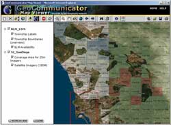
The GeoCommunicator module fulfills the mandate to make current land records data more readily available. This Web portal, created using ArcIMS and ArcSDE and hosted on the Geography Network, supplies a centralized location for land managers, data providers, and the public to access and share the most current land information. The GeoCommunicator was the first module implemented, and since 2001 it has been constantly updated. More than just a data node, GeoCommunicator sponsors a virtual land records community. By subscribing to an area of interest, users can receive notification of activities, events, undated datasets, new maps, and other related items. The portal promotes data sharing and collaboration, which avoids dataset duplication and unnecessary cost.
By embracing GIS as a framework for a system that goes far beyond a single agency, organization, or government entity, NILS is building a robust land records system that will greatly enhance the quality and accessibility of land information in the United States.
|
