Land Records From the Ground Up
It all starts at the ground level. Land records provide not only the basis for land ownership but are also used by government at all levels for income generation, land use planning, environmental management, public safety, public works, and a myriad of other applications. Businesses depend on access to current and valid land records.
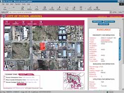 |
| The city of Tucson, Arizona, provides an example of how Web-enabling GIS benefits the dissemination of land records information. |
The quality of land records can make a difference in the everyday lives of people. As described in an article in the April–June 2002 issue of ArcUser magazine, improved land records can lead to palpable improvements in the quality of life. Prior to 1998, an inadequate cadastre and poor tax collection methods meant that the Costa Rican city of Turrialba was unable to generate the revenue needed to provide city services such as garbage collection and clean drinking water. With the assistance of the Tropical Research and Higher Education Centre (CATIE), the city developed a GIS that greatly improved its land records and doubled tax revenues in the first year. Better land records not only generated the income needed to provide services but also helped the city deliver those services.
Federal, state, and local governments are actively involved in the process of creating and maintaining land records. However, this process, usually spread across many agencies and departments, has historically suffered from much duplication of effort and attendant problems with data currency. GIS provides the framework for an integrated work flow for creating and updating the parcel fabric that can be easily shared both within and between organizations. Although GIS applications have been used to manage individual aspects of land records management for decades, the real benefits of GIS use can only be fully realized through applying GIS across the land records work flow.
The Esri family of software works together to handle the entire work flow from data creation to information distribution in an environment that supports information technology standards and interoperability with existing systems. The United States, Jamaica, and New Zealand are just a few of the countries that are in the process of implementing comprehensive GIS-based land records systems. This issue of ArcUser features articles describing how the National Integrated Land System (NILS) is providing a modern platform for land information development and dissemination in the United States. The "field-to-fabric" concept that this project is built on provides vertical integration between survey and measurement modules and parcel management. This ensures a tightly integrated and up-to-date parcel fabric and supports the creation of a multipurpose cadastre for the entire country.
The process of land records maintenance is comprehensively addressed by Esri software. The geodatabase provides advanced data storage and improved data editing. Data validation through the use of domains and subtypes enforces business constraints and ensures data quality while simplifying the user experience.
The geodatabase design allows for the development of common data models that not only model data more realistically but also provide a standardized method for developing and exchanging data. An article in this issue tells how Esri, in collaboration with experts in specific industries and disciplines, has been refining data models. The ArcGIS Land Parcel Data Model captures the collective experience gained from more than 20 years of managing parcels using GIS. This flexible and object-based model accommodates a range of applications and parcel definitions. In the United States, development of this data model is helping to promote the creation of the National Spatial Data Infrastructure.
With a vision for data exchange that goes beyond individual states or nations, Esri is working with the International Federation of Surveyors (FIG), the International Institute for Geo-Information Science and Earth Observation (ITC), and other industry experts on an initiative that lays the foundation for an International Cadastre Data Model. The ArcGIS Cadastre Data Model template will be based on Cadastre 2014 concepts. Cadastre 2014 refers to a vision of cadastral agency operations in 2014 using a modern cadastre system that is based on GIS technology.
Esri recently cohosted an international cadastre data model workshop at the ITC headquarters in Enschede, Netherlands, where more than 30 cadastre data modeling experts gathered to share their expertise. The workshop's goal was to refine the Cadastre 2014 data model so it could be used to implement core model requirements such as the management of multiple property rights and restrictions by cadastre agencies.
Enterprise GIS, with the geodatabase, data models, and an array of applications, is revolutionizing land records management. With the advent of ArcGIS 8.3, now more than ever before, GIS supplies the most comprehensive strategy for land records management. GIS users now have a robust and highly customizable suite of tools for creating and maintaining land records. Data entry options go far beyond traditional tablet and heads-up digitizing and COGO. ArcGIS can read many formats natively and contains an arsenal of data conversion and geoprocessing tools. ArcPad takes data gathering and verification into the field and exploits improvements in wireless technologies to enhance the speed of data updates. The improved cartography available in ArcMap includes more options for labeling and annotation, a critical aspect of land records mapping. The use of dimensioning, a type of annotation useful for parcel mapping and available in ArcGIS, is explained in an article in the Hands On section of this issue.
The ArcScan for ArcGIS extension, new with ArcGIS 8.3, supplies straightforward and controlled vectorization of scanned documents and works with the spatial editing tools available in core ArcGIS 8.3. These tools speed parcel editing tasks and eliminate the need to memorize or look up commands. Topology tools enforce spatial relationships that are user defined, handle coincident geometry, and accommodate versioning without requiring constant cleaning and rebuilding of the data.
A new data type available with the ArcGIS Survey Analyst extension allows surveyors and engineers to build a survey information system within ArcGIS. Survey points are stored and managed by ArcCatalog but are maintained separately from GIS layers. However, GIS layers can be made survey aware so that they can be edited using survey data. Existing spatial data can be made more accurate on an incremental basis that does not disrupt the work flow.
Three levels of licensing—ArcInfo, ArcEditor, and ArcView—can be used to tailor functionality to user requirements while keeping costs down. ArcReader, ArcExplorer, and ArcExplorer Web are available at no cost and provide several strategies for sharing maps and data within and between organizations as well as with the public.
Web-enabling GIS is another development that is greatly benefiting the dissemination of land records information. New Zealand's LandOnline Web site makes the 30 million records that Land Information New Zealand has amassed available online and has eliminated the need for parties in land transactions to travel to an office to conduct business. LandOnline has dramatically enhanced the speed and ease of performing land transactions. An article in this issue tells how Jamaica has consolidated four existing government agencies to streamline its land records work flow while providing the public and businesses with access to the most current information over the Internet.
ArcIMS, coupled with ArcSDE, powers land records Web sites while metadata creation and management tools support publication and location of spatial data. ArcCatalog includes tools for metadata creation. ArcIMS Metadata Services facilitate the publication and discovery of spatial data resources.
From field to office to the Internet, GIS enhances the land records work flow. It provides the framework for a modern and efficient land records management system whose benefits ripple throughout society.
|
