Spring 2008
Spring 2008 |
||||||||
|
|
||||||||
Purpose of the StudyThe study identified desirable locations for anticipated low-density residential projects in the Champaign�Urbana region, Illinois. The analysis was based on two almost contradictory approaches and compared the resulting maps.
The sites were analyzed and evaluated according to two scenarios. The first scenario was based on the developer's point of view and took into account the purchasers' preferences. This scenario considered the developer's preferences pertaining to economic and marketing factors. To that end, the developer was interested in maximizing profit and minimizing the cost of the development and paid little or no attention to environmental concerns. The second scenario was based on the environmentalists' point of view, which is the opposite of the first scenario. In this scenario, sites were ranked and evaluated on potential for engendering environmentally friendly development. In this regard, protecting the agricultural and forest lands and maintaining the integrity of the environment were the most decisive factors in influencing environmentalists' criteria and decisions.
Site Selection CriteriaThe site selection suitability analysis conducted for the study included weighing the different factors in both scenarios and ranking desirable sites. The outcome of both scenarios was evaluated and analyzed based on features of the site and features of the surrounding area.
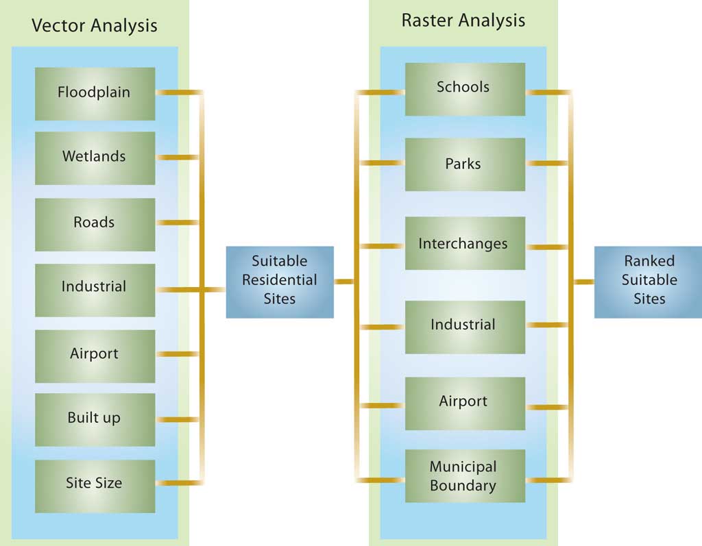
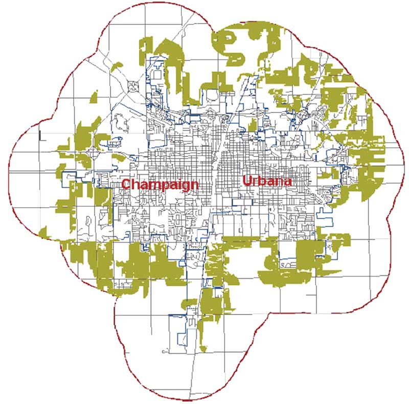
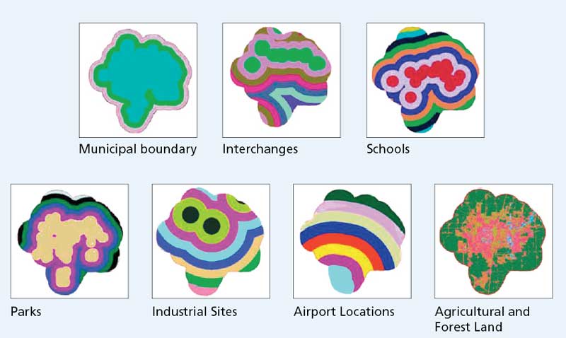
Analytic ProceduresThe analytic steps conducted in this study were combined into two major categories: vector analysis and raster analysis. Vector-Based AnalysisUsing vector-based geoprocessing tools, the final layers were juxtaposed on one map that showed sites initially identified as suitable for low-density residential development. At this stage of the analysis, the output did not reflect either the developer's or the environmentalist's concerns. Raster-Based AnalysisThis analysis considered the two scenarios, introduced in the beginning of the study, that represented a developer's viewpoint and an environmentalist's viewpoint. All layers were classified according to a 10-category color scale for consistency purposes.
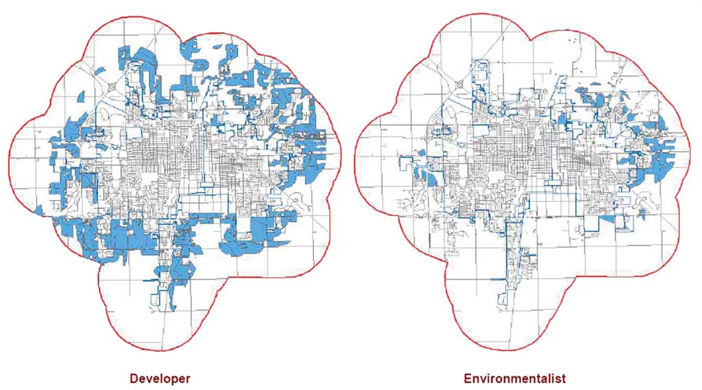
ConclusionThe findings from this study were mapped and provided a comparison of the results obtained from both scenarios. Suitable areas for the low-density residential development in the developer's scenario cover a significantly larger portion of the region than the environmentalist's conservative scenario. Because developers typically do not pay a great deal of attention to environmental factors, many more areas were proposed for development. Conversely, environmentalists' efforts to preserve the natural resources of the region greatly limited the amount of land perceived as suitable for future development. This study provided an example of how GIS could be used to support planning tasks and help make better decisions regarding real-world planning issues and develop communities more effectively. It emphasizes the role of GIS in urban growth management practice and land-use planning decision making. The study argued for the full utilization of GIS in ways that maximize its contribution to the planning practice instead of limiting its application to mapmaking and cartography only. GIS can deliver insights from data by identifying, displaying, analyzing, and deciphering real-world problems. GIS-based technology provides state-of-the-art analytical and management tools to spatially analyze and study patterns and spatial variations and correlations to make more informed decisions. For more information, contact Ahmed Baha' Abukhater, Ph.D. candidate About the AuthorAhmed Abukhater is a doctoral candidate in the community and regional planning program at the University of Texas, Austin, whose focus of study is water resources management and conflict resolution and mediation. He is interested in the geopolitical and hydropolitical aspects of water resources in the context of the Arab-Israeli conflict, the transboundary management of water resources, and multinational environmental policies in the Middle East. He holds a master's degree in urban and regional planning from the University of Illinois, Urbana-Champaign, and a bachelor's degree in architectural engineering from the University of Gaza, Palestine. With extensive experience utilizing and teaching GIS in planning fields, he has developed professional interests in GIS and community development, planning support systems (PSS), groundwater modeling, cultural hydrology, spatial morphology, and geospatial analysis and modeling. |