Spring 2008
Spring 2008 |
||||||||
|
|
||||||||
Developing an Extension for Decision SupportNatural resource managers must make potentially significant decisions, but the expertise of these managers and resources available to them vary greatly. Esri software was used to develop a decision support extension to help them manage river health in CMA regions. This extension is part of a process that provides a consistent and reproducible basis for making decisions. This process is sensitive to stakeholders' concerns and provides a means for prioritizing risk reduction activities, making risk reduction decisions, and measuring risk reduction progress. It was designed to aid natural resource managers who have little experience in improving river conditions but is also useful to more experienced natural resource managers.
The extension identifies and prioritizes areas of aquatic importance at catchment- and site-level spatial scales. Catchment-level analysis provides an indication of the relative priority of aquatic biodiversity over a CMA region and guides broad-scale decision-making. The site-level analysis provides the opportunity to assess local threats and risks to aquatic biodiversity and offers guidance for implementing appropriate rehabilitation activities. Using this extension helps
Assisting Natural Resource Managers
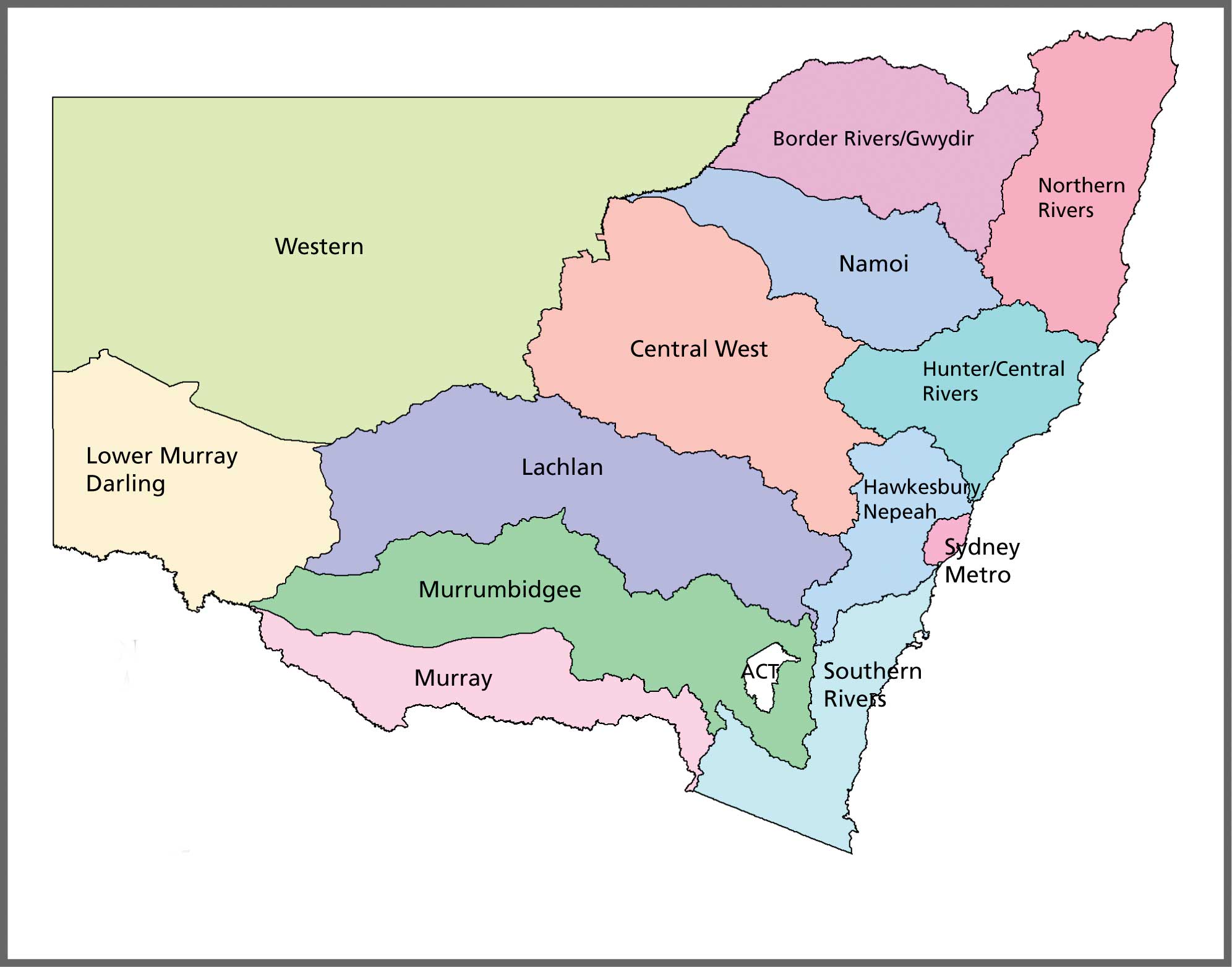
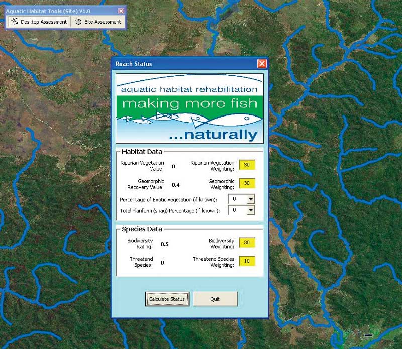
ArcGIS was chosen for developing the decision support tool because of its ease of customization. The tool should be flexible enough to work at both the catchment- and site-level spatial scales. The prototype version was developed as an extension for ArcGIS Desktop 9 using ArcObjects with Visual Basic for Applications. This approach allowed for quickly coding and testing ideas, methods, and models. When the decision support tools in the extension had been sufficiently refined, the code was converted to VB.NET for secure distribution to the CMAs. A more detailed description of the tools in the extension follow. Catchment ToolNatural resource managers can use the Catchment-Level Decision Support Tool or Rivers Tool to identify catchments of varying conservation value across an entire CMA region and gain a broad understanding of the likely condition of these catchments. The Rivers Tool facilitates broad-scale planning and can be used to focus on particular areas of interest. It works exclusively with Esri shapefiles and allows the user to vary weightings for key environmental indicators. These indicators include aquatic biodiversity, riparian vegetation, river geomorphology, and species threatened with extinction. The tool uses a variety of aquatic habitat and biodiversity data that can be weighted toward various attributes as determined by the user to assign a conservation value to each area. The relative conservation value attributed to a region can then be used to determine whether further assessment using the site-level decision support tool may be necessary. Site-Level Decision Support Tool
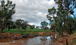
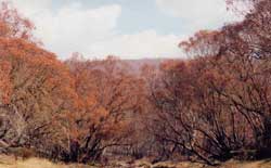
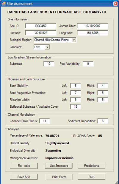
The tool for evaluating aquatic biodiversity at the site level was designed to provide a framework for making management decisions and reporting on the potential biodiversity benefits at the site level. It uses the Rapid Habitat Assessment protocol for conducting site assessments. This protocol was developed by the United States Environmental Protection Agency to evaluate the habitat integrity of rivers and streams at the site level. This protocol was adopted for evaluating aquatic biodiversity at the site level because it uses river habitat as a surrogate for aquatic biodiversity, requires few resources from managers with respect to expertise and equipment, and is time efficient. Prior to conducting a rapid habitat assessment, the rivers and streams in a CMA region are separated based on the biological region and stream gradient they fall within. This is done because regional and stream-size variability affects the flow, substrate, and channel morphology of rivers. This categorization also ensures that the measured parameters are appropriate for the region under consideration. The biological region and gradient for each river provides a context for establishing river condition for a region. This approach enables CMAs to set targets for maintaining healthy aquatic ecosystems or, in the case of degraded systems, use the Rapid Habitat Assessment Approach for setting goals to bring about significant improvements in the condition of a water body. Rapid habitat assessment emphasizes the potential faunal diversity present by measuring various habitat parameters that influence aquatic biodiversity such as riparian complexity and width, epifaunal substrate (in areas that likely include fish habitat), in-stream condition; and stream substrate complexity. Parameters are measured and the condition is identified based on the relative location of the river in the CMA region. Ten habitat parameters are evaluated visually at each site and given a Rapid Habitat Assessment for Wadeable Streams (RHAFWS) score, a numerical rating between 0 and 20. Scores for the 10 parameters are then summed, resulting in a total score that ranges from 0 to 200. These scores are compared to a reference score that reflects a habitat without degradation to provide a final habitat ranking. Higher scores reflect better quality habitats.
Using the Rapid Habitat Assessment protocol, natural resource managers can evaluate the potential faunal biodiversity associated with aquatic ecosystems at a particular site and gauge on-site threats that may be limiting aquatic biodiversity. To use this approach, natural resource managers can use personal digital assistants (PDAs) loaded with custom ArcPad 7 forms to record data for specific parameters of the Rapid Habitat Assessment protocol. Data collected in the field can be transferred to a desktop machine running ArcGIS with the Rivers extension tool so scores on habitat condition at the site level can be loaded. These site level river condition scores can be used by natural resource managers to identify potential stressors to river condition with respect to overall catchment condition. SummaryThe Catchment-Level Decision Support and Site-Level Decision tools work together to guide natural resource managers as they endeaver to achieve broad-scale conservation of aquatic biodiversity in each CMA. The catchment tool can be used by natural resource management to focus on particular areas for management activities. The Site-Level Decision Support tool provides natural resource managers with an opportunity to assess site conditions in the context of current catchment conditions and offers guidance for implementing appropriate management activities. ArcGIS, Esri's suite of products, was used to provide natural resource managers with a spatial context for making informed natural resource management decisions. It gives CMAs the opportunity to make explicit and transparent linkages between site and catchment prioritization levels and management activities and helps improve work practices, efficiency, and the quality of natural resource management decisions. Selected ReferencesBarbour, M. T, J. Gerritsen, B. D. Snyder, and J. B. Stribling (1999). Rapid Bioassessment Protocols for Use in Streams and Wadeable Rivers: Periphyton, Benthic Macroinvertebrates and Fish, Second Edition. U.S. Environmental Protection Agency, Office of Water, Washington, D.C. EPA 841-B-99-002. Barbour, M. T., and J. B. Stribling (1991). Use of Habitat Assessment in Evaluating the Biological Integrity of Stream Communities, G. Gibson, ed. Proceedings of a Symposium, Biological Criteria—Research and Regulation, Office of Water, U.S. Environmental Protection Agency, Washington D.C. EPA-440-5-91-005. Miller, L. J. (in prep). An Assessment Manual for Catchment Management Authorities to Evaluate the Aquatic Biodiversity of Their Rivers and Streams at the Site Level. Rivers and Wetlands Unit, NSW Department of Environment and Climate Change, Sydney South, New South Wales, Australia. About the AuthorsLiza Miller is a senior environmental scientist at the Rivers and Wetlands Unit of New South Wales Department of Environment and Climate Change. She has a doctorate in zoology and genetics and has completed postdoctorates in agricultural entomology and genetics. Miller has worked in aquatic ecology for the last six years and has developed systems in GIS to improve hydrological modeling practices. Since 2007 she has worked on developing a decision support tool for CMAs to improve their approach to river rehabilitation.
Mark Case is the spatial information manager for the Conservation Action Unit at New South Wales Department of Primary Industries. He is responsible for designing, developing, and maintaining spatial databases and interface systems to store information on rivers and streams in New South Wales. Case earned his bachelor's degree in information technology with an emphasis on spatial information from Charles Sturt University and has previously worked as the manager of Geospatial Information and Services at the Australian Hydrographic Office. Between 2000 and 2005, Case taught GIS and IT at a tertiary institution using Esri products. For more information, contact Liza Miller, Senior Environmental Scientist |