Easy Work Orders, Permits, and a Self-Maintaining GIS
Continued...
Handling and Tracking Requests and Work Orders
IndyGov's Mayor's Action Center (known internally as MAC) is a main call center similar to an information or nonemergency contact number (311). MAC handles approximately 1,300 citizen calls per day (or 300,000 calls per year). IndyGov recently implemented version 7.5 of Siebel's Call Center product. The resulting application, SAGA, was customized for IndyGov by Woolpert.
SAGA, like TAGG, is a server-based application developed as a Java-stored procedure. It is executed via a set of triggers within a Siebel database. Like TAGG, it is stored within an Oracle database schema on IndyGov's enterprise ArcSDE Server. When a service request is created, SAGA triggers a link to the ArcSDE Server and executes the Java procedure that creates geographic data based on the service request information gathered from the Siebel database. For service requests updated within Siebel, an update trigger is executed that queries the matching GIS feature within a Request for Service layer and updates the necessary attributes.
SAGA, using ArcSDE's Java functionality, generates GIS features for viewing within the Siebel interface. The application automatically generates geographic data within ArcSDE upon successful creation of a service request by the MAC call center within the Siebel customer relationship management (CRM) database. The geographic features are based on data gathered from the newly created service request in Siebel.
Siebel Call Center users create new service requests within the Siebel CRM software. The record is saved in the database. The user moves to the next service request and repeats this process. Meanwhile, an automated process is happening behind the scenes. As a new service request is saved to the Siebel database, a database trigger is executed that creates a connection via a database link to Oracle on the ArcSDE server.
 |
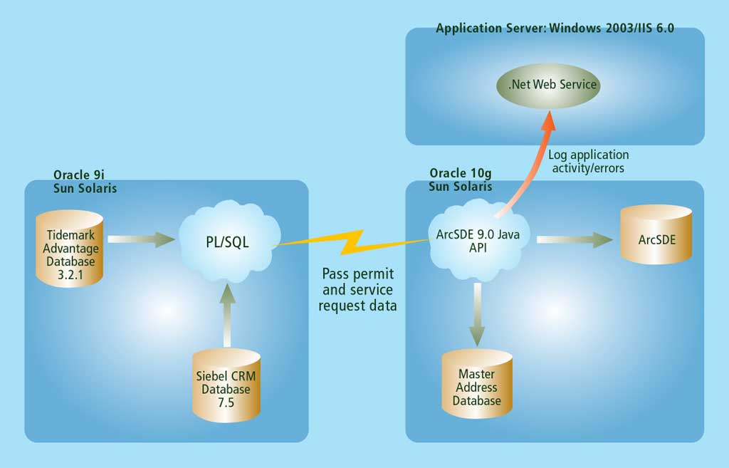
| TAGG/SAGA/GIS environment |
Unlike the TAGG application, a trigger is also executed as information is being updated on existing service requests in the Siebel database. As a database connection is created on the ArcSDE Server, related information is passed from Siebel to the Java procedure stored within Oracle. The Java procedure is executed and connects to ArcSDE.
If the process being executed corresponds to a new service request, the location of the service request cannot necessarily be related to a particular parcel. In this case, the address of the service request is geocoded and this location is returned as an x,y coordinate. The Java procedure then creates a new point feature that corresponds to the new service request and assigns the necessary attributes. If the process being executed is the result of an updated service request, a corresponding point feature already exists in the service request feature class in ArcSDE. The Java procedure queries for the matching point feature and updates the attribution that was updated on the record in the Siebel database.
Both the TAGG and SAGA applications consist of two main server environments and also access a third server environment. The Tidemark Advantage and Siebel CRM databases both reside in the Oracle 9i environment. As new information is added to each database, PL/SQL code is automatically executed to access the Java procedure stored within Oracle on the ArcSDE Server, which resides in the Oracle 10g environment. The Java procedure then uses the ArcSDE 9 Java API to interact with ArcSDE. If the new permit is a new building permit, then the Java procedure also inserts address information. Finally, if any errors occur in the Java procedure, then the error information is logged in a separate database using a Web service written in Visual Basic .NET.
Better Workflows and Service
TAGG works behind the scenes in conjunction with the GIS. IndyGIS users use this application and, in the future, internal IndyGov users with authorized access to the GIS will be able to tap the application via another application, the Automated Mapping Engine. This will allow non-technical, non-GIS users to create high-quality GIS maps. TAGG benefits citizens and IndyGov employees by leveraging the permitting process with behind-the-scenes procedures that save time and money and also enable analyses of permitting trends.
SAGA is intended to assist GIS and Siebel CRM database users within the city of Indianapolis/Marion County. This target group includes users who wish to simply view/analyze the spatial data associated with service requests and those involved in maintaining the spatial data. As with TAGG, SAGA is a background process and the data created by the application is utilized by users.
The data created by SAGA will allow call center staff to better manage daily workflow by quickly displaying where existing calls have been recorded as new ones are being entered. Staff can then group calls so repeat tickets aren't generated for the same problem. This will give IndyGov a much better method for targeting existing resources and cut down on redundancy. The Siebel CRM system increases IndyGov's ability to efficiently respond to requests and provides better information on the status of requests. Residents can quickly request information or services such as pothole repairs, snow removal, or stray animal pickup.
About the Authors
Joe LaCombe is a GIS system designer for Woolpert, Inc., in Indianapolis. Molly Klimas is a technology writer based in Grand Rapids, Michigan.
Why Choose These Methods?
Chuck Carufel, the GIS manager for IndyGIS, and Rick Petrecca, the project manager for IndyGIS, cited specific benefits derived from employing these methods for streamlining IndyGov's work order and permit process.
Invisible and Self-Maintaining Feature Creation
GIS features are automatically created behind the scenes with no need for manual involvement. In the SAGA application, the data is self-maintaining because the GIS features are automatically updated as the corresponding record is updated in Siebel.
Managed by Oracle
Using the ArcSDE Java API and Java-stored procedures enabled storage and execution of both applications within Oracle. In addition, the similarity of the two applications both enabled and justified a standard set of base classes and class inheritance. This allowed code to be shared and eliminated the need to rewrite code. Storage within Oracle provided an efficient and secure environment for these applications.
Simple Two-Server Architecture
Storing and executing these applications in Oracle met IndyGov's requirement for a two-server architecture. Storing these applications on a Web server would have introduced a third component.
Simple ArcSDE Interaction
Using the ArcSDE Java API was very efficient and allowed detailed and advanced GIS functionality to reside totally within the database.
Real-time Data Analysis
IndyGov plans to give city and county council members and IndyGov managers the ability to subscribe to the Automated Mapping Engine service so they can obtain maps and reports summarizing citizen requests for their districts. Because data is automatically generated as the permits and service requests are created, this subscription service will allow users to view and analyze the latest related GIS information.
|
|