October - December 2005
October - December 2005 |
||||||||
|
|
||||||||
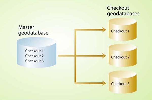
Combining ArcPad interoperability within a personal geodatabase with the disconnected editing tools available for ArcSDE, remote multiuser editing with ArcPad can be conducted more efficiently and with greater assurance of data integrity. This article discusses how disconnected editing and ArcPad interoperability can be used to optimize multiuser editing in the field. Enterprise GIS is driven by the needs of multiple users who edit different parts of the same enterprise database. ArcGIS provides tools that allow users to check out portions of the database, edit these portions, then check in only the edited features. Two strategies are available for remote, multiuser editing of a geodatabase—disconnected editing and ArcPad interoperability—that can be used independently or together. Disconnected editing works only from an enterprise geodatabase. It requires ArcSDE, either ArcEditor or ArcInfo, and a DBMS such as SQL Server or Oracle. Disconnected editing functionality includes tools for managing multiple checkouts, versions, and conflicts. By contrast, ArcPad interoperability requires only ArcView and ArcPad and can be used with either an enterprise or personal geodatabase. The benefits, limitations, and functionality of these two solutions are best explained by example. Imagine a management agency such as a national park that has a centralized GIS database. It has multiple divisions such as fire management, wildlife, and roads. Each division has one or more field crews, and these crews need geographic information. However, their needs vary widely. Some crews may only need a hard-copy map for the truck. Others may be collecting and updating enterprise GIS data. In either case, if many individuals are using and altering the enterprise GIS database, storage of data in a geodatabase and multiuser editing capabilities are required.
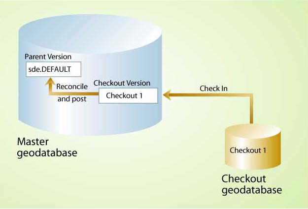
In this simple scenario, a single road crew for a small state forest is performing a culvert inventory with ArcPad and a GPS unit. Each day the crew comes to headquarters, plans the routes for the day, and gets the required data. Using ArcMap, either a field crew member or a GIS analyst selects the geographic extent, invokes the ArcPad toolbar, and checks out a subset of the data that is exported to a new dataset. The checkout process selects only features in the view extent of the data frame and honors layer properties such as visible fields, feature selection, definition queries, symbology, labels, and visible scale ranges. ArcPad doesn't work with the geodatabase, so checked-out features use the ArcPad interoperability tools to convert the data to shapefiles along with some associated files such as VBScripts (.vbs) and ArcPad layers (.apl). These files give ArcPad users some geodatabase-like behavior from the shapefiles, including subtypes and domains, which are manifested as edit forms. Topology and relationships are not honored, so if linked features are edited in ArcPad, relationships and topologies will need to be rebuilt. Using ArcPad and a GPS receiver, the crew maps the culverts and attributes them and creates work orders when needed. At the end of the day, the shapefiles are checked in using ArcPad interoperability tools, and new or modified features are incorporated into the geodatabase and committed at the end of the edit session. What if there are several culvert crews? If these crews will be working in different areas, there is no problem. However, if there is potential for overlap even on a single culvert, problems could arise. A geodatabase can manage multiple ArcPad checkouts, but there are no tools for managing conflict resolution. The most recent edits get committed and there is also no protection of the source data. While one crew is out in the field updating locations, the GIS analyst back at the office could be updating the same culvert locations based on new aerial photos. If the crew checks in its edits after the analyst has finished editing, the analyst's work will be overwritten. Although good workflow management should mitigate most of these problems, conflicts can still arise during the field season when crews are trying to get as much work done as quickly as possible or in large agencies that have many concurrent, overlapping projects. With either approach, users have the option of checking out the database schema without any data. This technique is useful for appending existing data with new features. Although both disconnected editing and ArcPad interoperability allow for multiple checkouts from the same geodatabase, and even multiple checkouts of the same features, the mechanisms for handling conflicts among multiple check-outs are quite different. With disconnected editing, the master geodatabase must be versioned so that data can be checked out. A duplicate of the database is created during versioning, which provides some data protection. During the checkout process, the selected features and layers are converted to another geodatabase that may be either an enterprise or personal geodatabase. Once the features are checked out, the same features in the versioned geodatabase are locked out from direct edit. While those features are checked out to a remote geodatabase, they cannot be changed in the master geodatabase. The checked-out geodatabase can be edited using all ArcMap's editing tools. A checked-out geodatabase contains all the relationships, feature-linked annotation, and topology rules in the master geodatabase. In the state forest example, the GIS data manager would version the master geodatabase and create checkout data for each crew. Check-outs may be customized and contain only data relevant and useful to specific tasks. Each division can then manage workflow within its own geodatabase either with subsequent disconnected editing checkouts (if their check-out from the master geodatabase is an ArcSDE geodatabase) and/or ArcPad checkouts. These checkouts could be periodically checked back into the master geodatabase for review and conflict resolution. Although the conceptual process is the same, there are key differences between disconnected editing and ArcPad interoperability with regard to conflict management, data formats and software, and data protection. ArcPad interoperability is a lighter-weight solution with less protection of the checked-out data and the source geodatabase. It also requires less overhead and, if carefully managed, is a viable solution for updating a geodatabase with field-collected data from one or several remote editors. Disconnected editing requires more technical management but offers more flexibility and power with data protections and conflict management. There are many opportunities for integrating these technologies into an enterprise GIS workflow. About the AuthorChris Wayne is the principal at Mazama Mapping, a GIS consultancy firm specializing in field GIS applications, GIS services, and GIS training. Wayne is also an instructor for the University of Washington, an Esri-Authorized Instructor for three courses, and a developer of custom coursework. Prior to founding Mazama Mapping, he spent more than three years with Esri, where he specialized in ArcPad, ArcGIS, and ArcGIS analysis extensions. He can be reached at mazama_mapping@hotmail.com or cwayne@u.washington.edu. |