Safeguarding Animal Health More Effectively
Animal identification programs in the United States date back more than 100 years. In the late 1800s and early 1900s, ownership of large animals was verified by branding or ear notching. Later, individual animal identification systems, maintained using ear tags, tattoos, and other methods, were needed for registration and record keeping. These identification systems were subsequently expanded for use in tracing the movement of infected animals during disease outbreaks and as part of disease eradication programs.
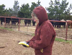 |
| Dr. Leslie Cole, a staff veterinarian with the Oklahoma Department of Agriculture, Food, and Forestry, Animal Industry Services, enters premises data using a GPS unit. |
Efforts to expand and enhance animal identification and tracking in the United States are now driven by additional and more pressing issues—possible homeland security threats to the food supply; the need for coordination with emergency management programs; consumer concerns about food safety; and the challenges of disease surveillance and response in an era of global trade.
In 2004, the United States Department of Agriculture (USDA) Animal and Plant Health Inspection Service (APHIS) announced the National Animal Identification System (NAIS). The difference with this plan is that it proposes to comprehensively identify and track the movements of farm animals and some other kinds of animals in a way that is well documented and allows for a complete trace back in a very short period of time—48 hours. This more robust requirement is part of homeland security efforts but also has benefits for responding to and managing naturally occurring disease outbreaks.
USDA has entered into cooperative agreements with state and tribal governments to implement a national animal identification system. This system will provide officials with the information necessary to safeguard the national food supply from attack by terrorists or natural disease outbreaks. NAIS offers a unique opportunity to develop a system that protects animal health while protecting the public.
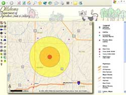 |
| The ArcIMS Data Viewer screen displays a single infected premises and the three-tiered buffer zones showing icons that identify layers of interest specific to the type of outbreak. |
The system's goal of identifying animals and premises that have been exposed to disease within 48 hours of the outbreak report requires registering animal premises, gathering animal identification data, and tracking animals through the system.
Geography plays a major role in understanding the dynamics of animal health and the spread of disease. The geography-centric nature of this system makes GIS the ideal technology choice. Like many government agencies, USDA has embraced GIS as a framework for performing research, communicating results, and delivering services to the public.
Agricultural products originate at a specific location and are transported through the market chain to consumers. GIS can integrate information into a common picture for coordinating both surveillance and detection activities. Mapping outbreak events reveals spatial relationships, such as clustering, and allows analysis with other data such as transportation infrastructure or environmental factors.
The first step in implementing a national animal identification system is identifying and registering premises associated with the animal agriculture industry. Identifying premises where animals mingle must be established before animal movement can be tracked. Currently, more than 90,000 animal premises have been assigned unique premises identification numbers.
During a disease outbreak, animal health authorities can easily access premises location data from a GIS and investigations can progress rapidly and efficiently. In addition, mobile GIS aids in rapid reporting and updating of information from the field so outbreak trends can be identified.
Through NAIS, tribal, state, and local governments are developing innovative approaches that take advantage of GIS technology to control, eradicate, monitor, and survey animal diseases. The Oklahoma Department of Agriculture, Food and Forestry (ODAFF), Animal Industry Services is implementing a NAIS premises identification program using GIS.
ODAFF's program, developed with authorized Esri consultant and reseller Strategic Consulting International, inventories infrastructures critical to animal agriculture, allows identification of infected premises, and profiles potential disease outbreaks. ODAFF's ArcIMS site can generate buffer zones surrounding an infected premises and quickly identify critical infrastructure data within these buffer zones. This program makes data readily accessible and supports field response capability in the face of an animal emergency.
|
