DOT Develops Robust Enterprise Geospatial Repository
By Dan Widner and Paul Bucher, Virginia Department of Transportation
Editor's note: Using an iterative design, build, and review process, the Virginia Department of Transportation (VDOT) has implemented and extended the Unified Network Transportation Data Model (UNETRANS) to address the many transportation modes it manages and establish an enterprise-wide data repository. This article describes the process VDOT used and the lessons it learned.
VDOT is responsible for maintaining the state's approximately 57,000 miles of roads. This mandate includes not only traditional state DOT responsibilities, such as inventorying asset and roadway characteristics, but also innovation in areas such as intelligent transportation information for mobility management. A geospatial approach to transportation information management requires a roadway network and the ability to use a variety of location referencing methods for managing and accessing information.
In 2001 VDOT implemented an enterprise geospatial data repository using Esri technology, This repository provides geospatial information to end users and integrates with applications that support decision making. Although much of this information had been geospatially enabled, a truly comprehensive geospatial data management approach for roadway information had been lacking.
To achieve this more robust system, VDOT built a unified transportation geodatabase that leverages GPS-derived roadway centerlines to meet both current and future needs. The geodata model was based on UNETRANS and customized to meet VDOT's business needs. While developing the model, VDOT looked for industry-standard-compliant, off-the-shelf tools for editing, creating, and maintaining network data.
The UNETRANS model was developed as a generic object-oriented model in standard UML and XML export. Although VDOT was already using Esri-based tools, the 8.2 versions of ArcMap editing tool functions for maintenance were lacking.
However, ArcGIS 8.3 supplied the ArcMap tools for network and topology that were lacking in ArcGIS 8.2. VDOT realized it now had the capabilities needed to support the agency's growing needs and committed to the new tools. In addition, a full complement of CASE tools for customizing and documenting the model were exploited. VDOT has been following an iterative process of design, build, and review with an ever-expanding circle of internal and external stakeholders.
Meeting High-Level Requirements
VDOT's transportation geodata model needed to address a wide range of locations and events that are part of the transportation network- bike trails; commuter parking lots; travel from bus, air, port, and rail stations; statewide emergency operations centers; and road closures.
VDOT has also been involved in Intelligent Transportation Systems. Virginia's Smart Traffic Centers are exploiting technologies that allow the public to access and utilize real-time or near-real-time information about events on the transportation network. Based on these goals, VDOT developed high-level business, technical, and data model requirements that would support the transportation network and its associated elements. These requirements are listed in the accompanying table.
Standardization for Sharing
Standardizing location referencing was necessary so location information could be shared between applications. In its simplest form, this means attributes can locate data on a map. For example, a standard route name and mile point used with linear referencing or latitude/longitude would be acceptable, but not descriptive text such as "Location = Intersection of State Route 211 and Broad Street" or "5.4 miles from the county boundary." Location standardization enables integration with other spatial and business data.
Evaluating the Model
VDOT determined that the UNETRANS template model contained the required items and that those items could be extended to meet VDOT's needs. Although all model items are not currently included, these items will eventually be added and populated.
Viewed thematically, the model has three levels: the base network, routes, and events. The base network is composed of individual intersections/junctions and connecting transportation segments (edges). Routes combine multiple transportation segments from the network along with a measure system that can find locations along the route. Events are the assets, activities, incidents, or mobile objects that can be placed based on the route and measure used. The thematic view is most easily understood when visualized as shown in Figure 1.
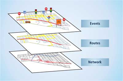 |
| Figure 1: Thematic view of UNETRANS model |
The conceptual model has the same three levels—network, routes, and events—and is shown in Figure 2. VDOT primarily concentrated on defining the base network, location referencing, and assets. A base network can be defined as the connected points and lines that represent the geometry features used to derive all other routes and events. Figure 3 shows the base network and the two classes used to model the network of VDOT roads: the point intersections and line road feature classes. The logical UNETRANS data model and the physical data populated in the tables are closely related.
Continued on page 2
| Business Requirements | Technical Requirements | Data Model Requirements |
| Manage public roadways information per the Code of Virginia mandate. | Support rules for topology to prevent dangles and overlaps and ensure appropriate connectivity of the network between intersections and road segments. | Provide an accessible and spatially enabled transportation network that facilitates business data integration. |
| Enable business data integration from key areas of construction, maintenance, operations, planning, and environment with common roadway location information. | Support robust editing tools. | Enable analyzing business data in a spatial context within and between application systems. |
| Provide federal reporting such as the Highway Performance Monitoring. | Enable multiple data editors and help resolve conflicting edits of the same data by different users. | Enable archiving the network at a given point in time by segment and intersection. |
| Share roadway information with the traveling public, local governments, metropolitan planning organizations, and the private sector. | Support temporality and the ability to re-create the network and associated business data at a given point in time. | Allow direct utilization in print and Web mapping applications. |
| | Enable data sharing with other applications utilizing XML Web services. | Support future multimodal network applications across various modes of transportation. |
| | | Facilitate data exchange between the localities and the state and between state agencies. |
High-level business, technical, and data model requirements
|