October - December 2006
October - December 2006 |
||||||||
|
|
||||||||
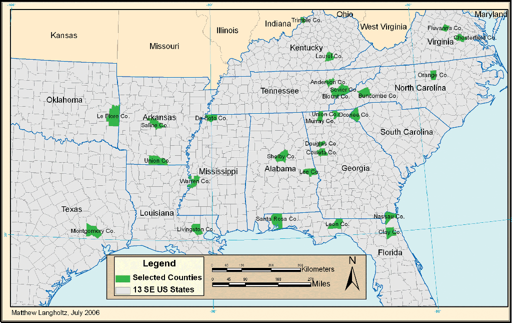
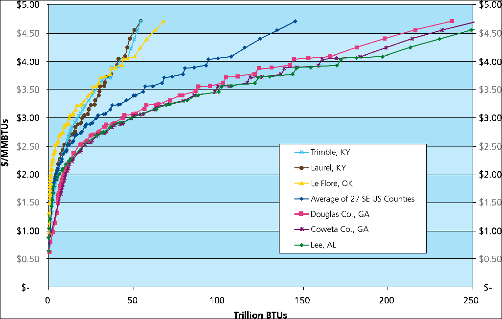
Biomass resources in the southern United States, such as urban wood waste, forest residues, forest thinnings, and others, can be used to generate renewable energy, reduce greenhouse gas emissions, improve forest health, and provide economic benefits to rural communities. The feasibility of bioenergy (i.e., energy generated from biomass) projects depends largely on the availability of woody biomass resources. More specifically, it is the economic availability or total delivered price for a given quantity, rather than just the physical availability, that is relevant to the development of bioenergy projects. Most assessments of biomass availability to date estimate the total amount of biomass within a given straight-line radius and assume average production costs for the area. A more comprehensive economic assessment of biomass resources takes into account that costs vary with biomass type, distance, and transportation infrastructure. When transportation costs are taken into account, more costly resources in close proximity may be economically competitive with cheaper resources farther away, and vice versa. The Wood to Energy program of the University of Florida School of Forest Resources and Conservation, the United States Department of Agriculture Forest Service's Southern Center for Wildland-Urban Interface Research and Information, and the Southern States Energy Board helps communities evaluate the feasibility of using woody biomass for energy production. The project has identified 27 counties in the southeast portion of the United States that have high potential for energy generation from woody biomass. The ArcGIS Network Analyst extension was used in assessing the economic availability of woody biomass resources to these communities. Components for Calculating Economic Availability
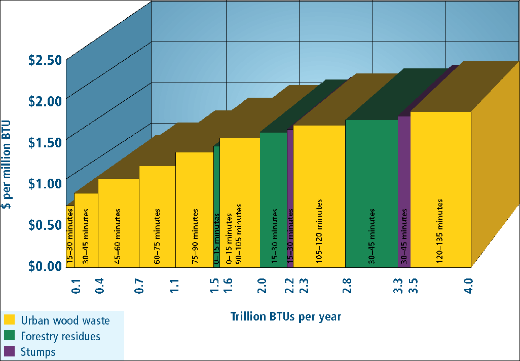
Assessing the economic availability of biomass requires information about production costs and the physical availability of biomass resources in the area of interest. The methods used are composed of the following three components: calculation of transportation costs and haul times, determination of physical availability and geographic distribution of biomass, and creation of biomass resource supply curves. The delivered cost of woody biomass can be defined as the sum of procurement (i.e., the amount paid to gain ownership of a biomass resource), harvest, and transportation costs. This requires assembling procurement and harvest cost assumptions for different types of biomass resources and calculating transportation cost as a function of haul time. GIS is an efficient and useful tool for evaluating woodshed procurement areas and transportation costs (e.g., Young et al. 1991, Brewington et al. 2001, Chalmers et al. 2003). Assessing transportation cost based on haul time rather than distance accounts for site-specific road infrastructure and geographical constraints within a woodshed. Calculating Haul Time
Determining the proportion of each county within a given haul time category was the first step. Haul times were calculated to account for road infrastructure. Using the Field Calculator in ArcMap, speed limits were assigned to road features in U.S. Census TIGER shapefiles and road lengths were divided by speed limits to estimate travel time. The Service Area function in the ArcGIS Network Analyst extension was used to calculate service areas based on travel time and the proportion of each county. Each haul time category was based on a 15-minute interval. The procedure for calculating haul times by generating service areas with ArcGIS Network Analyst can be used for specific locations of biomass drop-off such as bioenergy generation facilities. For the 27 counties in the study, the delivery point was calculated using the Centroid function of Xtools Pro 3.2, a third-party extension to ArcGIS from Data East, an Esri business partner and international distributor. The area of interest (AOI) was defined as counties within the maximum potential extent of the woodshed defined as a 450-kilometer (or 280-mile) radius to include greater than a four-hour one-way haul. U.S. Census TIGER road shapefiles were downloaded from arcdata.esri.com/data/tiger2000/tiger_download.cfm for the counties in each AOI. Using ArcToolbox, the TIGER county roads shapefiles were merged and projected into the appropriate State Plane coordinate system for each AOI. (For a tutorial on this procedure, see "Taming TIGER Data: Create Emergency Management Maps Using Census 2000 Data" by Mike Price and Ronny Coleman in the January–March 2003 issue of ArcUser.) The Field Calculator was used to assign speed limits to road features based on the attribute census feature class codes in U.S. Census TIGER shapefiles, and road lengths were divided by speed limits to estimate travel time. (For more information on using census class codes, see "Coverage Assessment Using Census 2000 TIGER Roads" by Mike Price and Jennifer Price in the July–September 2003 issue of ArcUser.) Continued on page 2 |