A Symbiotic Relationship
Conference explores where survey and GIS intersect
More than 400 surveyors convened for the 2006 Survey and GIS Summit at the San Diego Convention Center in San Diego, California, from August 5 to 8 to discuss what is new, what is changing, and what is in store for the future of surveying and GIS.
This year's summit focused on the intrinsic relationship between surveyors and those, such as GIS professionals, who rely on spatial data. "We're going to talk about the successes that surveyors have had with GIS and the new things that GIS has to offer surveyors; but most important, we're going to talk about what surveyors have to offer GIS," said Brent Jones, Esri surveying industry solutions manager, as he kicked off the Summit's Plenary Session. Jones' sentiments echoed throughout the summit as surveyors dove into the newest GIS technology and explored their role in the evolving GIS field.
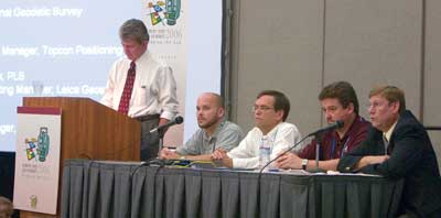 |
| (Left to right) Curt Sumner, executive director, American Congress on Surveyng and Mapping (ACSM), moderated the industry panel discussion. Jason Kandrick, product marketing manager, Leica Geosystems, Inc.; John Stenmark, segment manager, Trimble Navigation Ltd.; Peter Wallace, national sales manager, Topcon Positioning Systems, Inc.; and Dave Zilkoski, director, National Geodetic Survey, participated in the panel. |
The symbiotic relationship between surveyors and GIS was a common thread throughout the summit's technical sessions, demonstrations, and presentations, and an air of anticipation charged discussions of the software enhancements that will be available with the release of ArcGIS Survey Analyst 9.2. The new cadastral editor, which will include a new set of tools for maintaining land records in ArcGIS Survey Analyst 9.2, was a popular topic.
More than 20 surveyors from several organizations and agencies, including the California Department of Transportation (Caltrans), Colorado Springs Utilities, and Santa Barbara County, attended a beta class that worked with the software and its new functionality. The class introduced the cadastral fabric dataset and took participants through the process of adding data from survey plans and other record measurements and applying Least Squares Adjustments for positional improvement. Exercises spanned a range of capabilities from creating and managing a cadastral fabric and creating new parcels to working with new parcel construction tools and adjusting the parcel fabric.
Aside from the new technology, the summit offered valuable input from leaders in the field. The keynote presenter was Wendy Lathrop, professional land surveyor (PLS) and certified floodplain manager (CFM), who has worked in the field since 1974 on a variety of projects ranging from construction to boundary to environmental land-use disputes. "Over the decades, GIS has been evolving," Lathrop told the audience of surveyors and engineers. "GIS practitioners are no longer our enemies. They want to make more accurate data."
Lathrop emphasized the industry's important role. "Surveyors have a big role in the new world where data accuracy and integrity are so important." Lathrop also emphasized the importance of GIS technology for surveyors' business and project management as a tool to streamline workflow, track projects, and separate information for specialized analysis.
Following Lathrop's presentation, the summit featured an industry panel that let surveyors ask leaders in the field specific questions. Curt Sumner, executive director of the American Congress on Surveying and Mapping (ACSM), moderated the session, which included representatives from the National Geodetic Survey (NGS), Trimble, Leica, and Topcon. The panel and audience discussed the future of surveying with issues ranging from education and how to entice younger professionals to the evolution of GIS technology for surveyors.
The summit extended the theme of collaboration beyond just surveyors and GIS professionals to encompass anyone who depends on geospatial information. "The Survey Summit was an invaluable experience for me as an archaeologist just beginning to use GIS," said Dr. Margaret Purser of Sonoma State University, California. "It was an opportunity to compare GIS technology applications across disciplinary and professional lines."
|