October - December 2006
October - December 2006 |
||||||||
|
|
||||||||
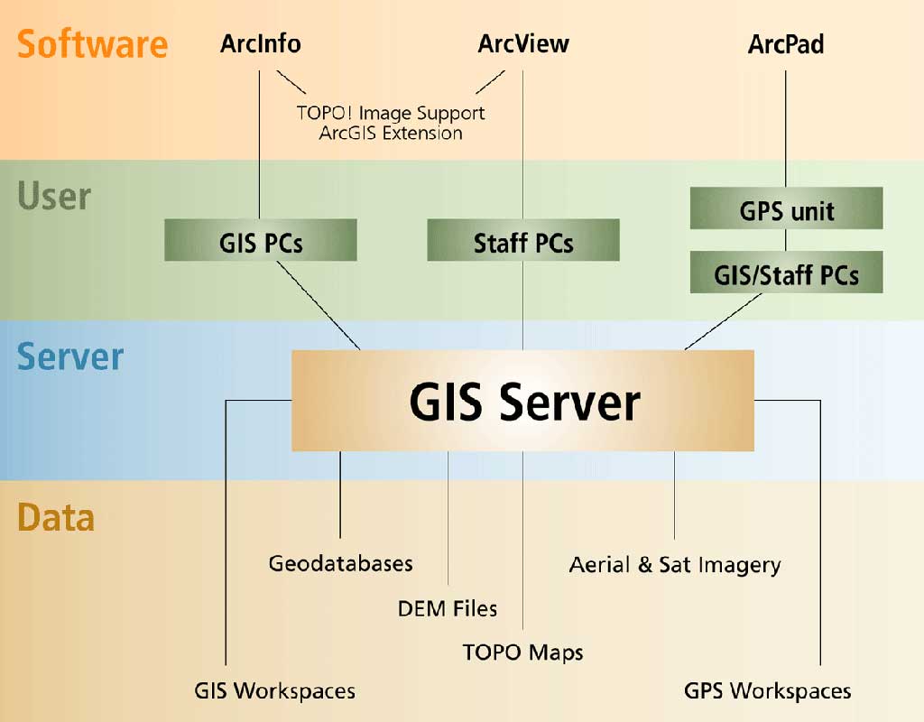
The GIS department of the Pueblo of Zuni, a Native American tribe located in western New Mexico, is charged with developing and maintaining GIS databases and software in support of a variety of management activities related to agriculture, archaeology, cultural, range, restoration, water, and wildlife. As part of its GIS implementation strategy, the GIS department wants to empower all staff members working in these land management areas who use geographic information with both data access and collection capabilities. To accomplish this objective, the department designed and implemented an integrated GIS system architecture that features customized GIS data storage structures and standardized GIS data collection procedures. Together, these components create a workflow process that lets all system users utilize the spatial data and GIS functionality required to accomplish tasks ranging from simple mapmaking to multistage GIS data analysis. The architecture's overall structure is divided among components residing on the user side and GIS server. The GIS server is further delineated by applying a set of data management concepts and considering the needs of the organization. Making Data AccessibleThe foundation of the GIS system architecture is a single server that stores all GIS data and is accessible to all system users via an office intranet. This configuration allows all users to map a network drive to a folder in the root directory of the GIS server and use ArcCatalog to create a connection to the data. Having all GIS and GIS-related data stored in subfolders of this mapped folder creates a common access path. With this common path, all users can share all map document files created in ArcMap because the GIS data is accessed from the server. In addition, if all users use the same logical drive letter to define the network drive that connects to the GIS data, all map document files can also be shared among all users even if these files are not saved using the Store Relative Path Names option. The system architecture was further developed by arranging GIS and GIS-related data on the server. Data is initially classified as either permanent or temporary. Permanent data has been subjected to quality assurance/quality control (QA/QC) to ensure all required standards and specifications have been met and that the data will be available to all system users. Data classified as temporary is either being generated and developed or utilized only by a specific user or group of users for a specific project and/or limited time. While permanent data can be stored in a single, unique set of folders and subfolders, temporary data requires that a set of folders and subfolders for the storage be assigned to the user or group of users.
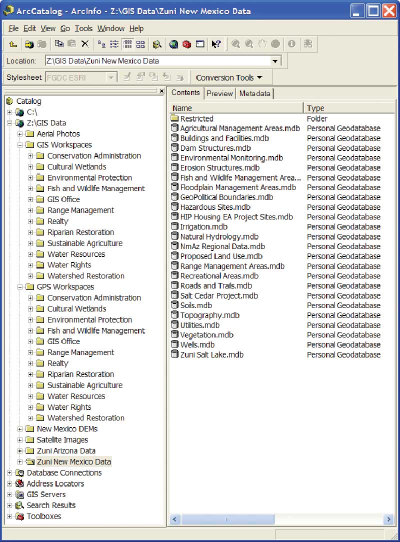
Permanent data is initially delineated by type. At the first level of subfolders below the mapped folder in the root directory of the GIS server, each type of data is stored in a separate folder. Permanent data is divided into five major types—personal geodatabases, aerial imagery, satellite imagery, digital elevation model (DEM) files, and topographic background maps. The Pueblo of Zuni also owns a small amount of land located in Arizona so separate geodatabases have been developed for New Mexico and Arizona lands. The topographic maps are generated using the ArcGIS TOPO! Image Support extension and are placed elsewhere on the GIS server. These maps can also be shared among all users by defining a separate network drive to the folder where TOPO! stores the maps it generates within ArcMap. Developing DataTemporary data is initially delineated by purpose, either for GIS (spatial data analysis) or GPS (spatial data collection) work activities. These folders are referred to as Workspaces and are further delineated by assigning each department and program within the tribal government an individual workspace folder under both the GIS and GPS categories. Workspaces for GIS contain temporary data—primarily geodatabases and imagery files. Separate GPS workspaces give all users access to the ArcPad application and the ArcPad toolbar in ArcMap used for collecting and/or upgrading spatial data in the field. In this scenario, geodatabase feature classes are taken from a user's GIS Workspace folder and converted to shapefile format via the ArcPad Toolbar within ArcMap. These shapefiles, saved in the user's GPS Workspace folder, can be uploaded to a GPS unit running ArcPad. After data is collectd in the field, this process is reversed to populate the original geodatabase feature classes with newly collected spatial and attribute data. Separating GPS from GIS data avoids duplicating and confusing data while making spatial data collection accessible to all users. With the workflow, all users can contribute to the archive of permanent data. Collected spatial data is initially stored in a user's GIS Workspace folder as temporary data. If this data is collected to expand or update the archive of permanent data, the organization's GIS staff can QA/QC the collected data, and upon verification that the data is valid and meets all required standards and specifications, it can be copied and placed in the appropriate permanent data folder and can become available to all system users (dependent on any permission restrictions). Customizing AccessWhile this GIS system architecture provides all users with access to spatial data and GIS functionality, this access can be customized and/or restricted. GIS personnel will obviously require complete access to all data (i.e., read/write permission to all folders) and to total GIS functionality (i.e., an ArcInfo license). Staff from other departments will normally require
For example, limited-access users would be granted reading and writing permissions to their own GIS Workspace and GPS Workspace folders while being granted only reading permission to all the folders containing permanent data. This eliminates the possibility of personnel other than GIS staff altering or otherwise corrupting the permanent GIS data. In addition, both reading and writing permission can be denied to any individual folder containing data that is not meant to be shared among all users (i.e., restricted or classified data). Regarding GIS functionality, users other than GIS staff may only require ArcView licenses. At the Pueblo of Zuni, each GIS staff member has an ArcInfo license while the rest of the tribal staff share five floating ArcView licenses. Accommodating ChangeThis architecture can also be easily modified, expanded, or scaled as needs change. Adding or removing software, users, servers, or data does not alter the existing structure. A set of guidelines for making changes to the system architecture ensures that the system's inherent functionality is maintained. For example, ArcIMS, along with Web server software and a servlet engine, was added to the GIS server. ArcIMS uses GIS data already stored in the server to create both image and feature services. Because ArcIMS requires only a Web browser to view GIS data and perform simple mapmaking activities, these services are used to give staff members who do not have ArcGIS installed on their PCs access to GIS data. The GIS system architecture gives all GIS users the tools for undertaking a wide range of GIS activities. It serves the needs of both beginning and advanced users equally well. For users with limited GIS skills, this system helps them learn new skills more easily because both spatial data and GIS functionality are easily accessed. At the Pueblo of Zuni, this system has motivated non-GIS staff to learn and subsequently apply GIS techniques to their work in areas such as riparian restoration, range management, and sustainable agriculture. This, in turn, has rapidly accelerated the growth of the archive of spatial data as more individuals are participating in the process of data collection. In addition, GIS staff members spend less time on simple, repetitive tasks and can devote more time to pursuing advanced GIS work activities such as developing complex analytical methodologies and creating customized software tools that address the specific GIS needs of the pueblo community. For more information, contact Ed Durbeck |