In the last issue of ArcUser, we introduced the U.S. Geological Survey's Earth Resource Observation Systems (EROS) Internet data site in the article "Finding Data for 3D Terrain Modeling." The EROS site provides free downloadable data for GIS users.
This article summarizes the steps necessary to locate and download USGS topographic 1:100,000 scale digital line graph optional (DLG-O) format from the FTP site and to process this vector data into Drawing Exchange Format (DXF) files. DXF files are easily loaded into ArcView GIS using the CAD reader extension and are used for mapping and modeling.
Other data types such as digital elevation model (DEM), data at scales such as 1:250,000 or 1:24,000, or data in other formats including Spatial Data Transfer Standard (SDTS) are available through EROS and related sites. After you master techniques for downloading and converting DLG-O format data you can explore other formats. Solutions for additional data types and formats will be featured in future issues of ArcUser as well as more methods and tips for modeling DLG, DEM, and other data with ArcView GIS and the ArcView GIS extensions.
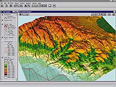
The examples used in this article were created using data from the EROS site. The demonstration model uses data that refer to the north end of Death Valley on the California-Nevada border. However, the techniques presented can be used to create similar models using data from almost anywhere in the continental United States.
What Is
Available at EROS
USGS 1:100,000 topographic
maps are available in digital form at the EROS U.S. Geo Data Web site.
Use the key words "USGS DLG" to locate the site using most Internet search
utilities or use the exact URL shown in "URL List for USGS Data." Once
at the EROS site, explore down through the different data
types to find the 1:100,000-scale DLG page.
Just like paper maps, the 1:100,000 DLG data are divided into 30-by-60 minute sets that are indexed by the USGS quadrangle name. The data are registered using metric UTM values according to the North American Datum of 1927 (NAD 27). Data sets can be accessed by name from the "FTP via State" page at the Geo Data Web site. Open the folder for the desired state, then search for the map name. Data sets in these folders are arranged alphabetically by map name. To find a map when the name is not known or to just explore, look on the "FTP via Graphics" page to use a graphic search tool.
Finding,
Downloading, and Unzipping DLG Data
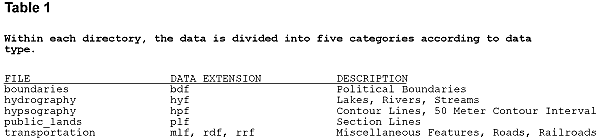
Each 30-by-60 minute
quadrangle is divided into eight 15-minute tiles, four on the north and
four on the south. The northern tier is numbered from one to four, from
west to east, beginning with the top left or northwest 15-minute tile.
The southern tier is numbered from five to eight, again beginning on the
west side. The halves are further divided into west and east, so that
each FTP directory contains four 15-minute tiles. Data for each tile can
be located by understanding the numbering scheme shown in Figure 1 for
the Saline Valley, California, quadrangle. It helps to have a paper map
of the quadrangle handy while you search for the DLG data.
Each 30-by-60 minute quadrangle, 15-minute tile, and data type is coded into each file name using the following convention: [3 character quad code]. [3 letter data code][2 digit 15 minute code].opt.gz.
The "opt" suffix indicates optional format and "gz" indicates "government zip," a zip format. The files are automatically unzipped by some browsers, or can be manually unzipped using utility programs such as WinZip.
All five component files boundaries, hydrography, hypsography, public lands, and transportation, should be downloaded into a single directory for all of the 15-minute tiles that you need. By understanding and following the USGS file naming conventions, you can track the data. Data will automatically be kept separated until read into a common DXF file as explained later.
The processing software is a DOS program called DLGLX149.exe. Consequently, files MUST have eight character names, followed by the extension .dlg. Strip unnecessary characters out of the file name when unzipping the file. The unzipping utility will prompt the user for the name of the contained file. For example, the file EO1.BDF03.opt.gz should be unzipped and saved as EO1BDF03.dlg. Following this convention retains the meaningful file name AND is DOS compatible.
Finding
and Downloading the DLG to DXF Conversion Utility
To load DLG-0 data
into ArcView GIS, we recommend converting the DLG files to AutoCAD Version
12 compatible DXF. Once loaded, the CAD reader in ArcView GIS will read
the DXF files directly. These files can be used "as is" in native DXF
format or converted to shapefiles for editing, mergining, and clipping.
David Bunch, a CADD operator and programmer from Portsmouth, Virginia,
has developed a DLG to DXF conversion utility that runs in DOS mode. This
utility, which is freeware and may be downloaded from his Web site (see
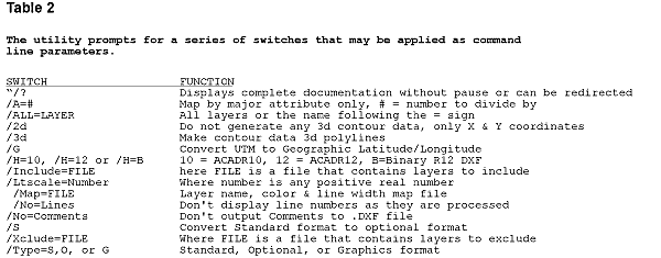
URL information box on the left), uses a series of DOS switches and parameters
(see figure 2).
Bunch recently released DLGLX149.exe, which replaces an earlier version, DLGLX133.exe. The utility is part of a zipped set that also contains documentation, sample data, and additional conversion tools. Once downloaded, use an unzipping utility to extract DLGLX149.exe and other files. The file DLGLX149.doc contains detailed information about this program.
Bunch's conversion utility is very stable and highly functional. We recommend you use it to convert USGS DLG optional format data. Comments to the author through his site log are appreciated.
Unzipping
and Processing DLG Files into DXF Files
Store the unzipped
copy of the DLGLX149.exe utility in the same directory as the extracted
DLG files. At a DOS prompt or in a DOS command window, invoke the DLGLX149.exe
program by typing DLGLX149.
The following switches work well with AutoCAD 12, 13, and 14:
/3d /h=12 /no=lines /no=comments /type=o
You may want to experiment with switches that serve special purposes, such as the /G switch to convert UTM to geographic latitude/longitude coordinates in NAD 27. In automated mode, the program first prompts for the AutoCAD version. Version 12 is the recommended default. Enter Switches [H=12]: <RTN>. Additional switches may be added here.
Next you are prompted to enter the file names of the input files. Type the path and name of the DLG file you wish to process. If you use wild cards such as *.DLG or DV1*.DLG to process several DLG files into one drawing, make sure the resulting file will not be an unwieldy size.
The program then prompts for the output file name. Enter the first eight characters of the input file name and add the DXF extension. The USGS convention is recommended (e.g., DV104.dxf for multiple data types or DV1hpf04.dxf for single data type).
Finally, the program prompts for line width. A value of zero (0) is recommended. Enter line width [0]: <RTN>. Sit back and watch the program execute.
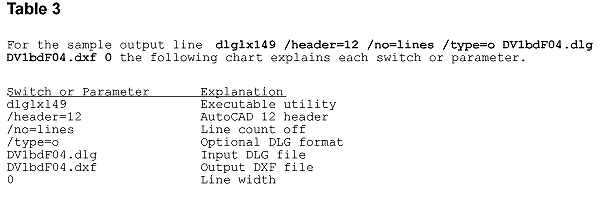
An alternative to using an interactive DLG to DXF conversion procedure is to use a DOS batch file to automate data conversion. The batch file calls the DLGLX149 program, applies necessary switches and parameters, and specifies input DLG and output DXF files. The batch file is first created in a text editor and should be stored in the same directory as the DLG files and the conversion utility. Each batch file line includes seven items. A separate line is created for each input/output desired. A single line from a typical file is shown in Figure 3.
The batch file automates extraction and permits the user to quickly repeat a conversion step if the first pass does not execute properly. If certain DLG files do not convert properly, simply delete the incorrect resulting DXF file, edit the batch file to fix any errors, and rerun the corrected batch file. Correct DXF files in the project directory will not be rewritten. The batch file can also be copied to a new project area, edited, and used as a template for additional conversions.
Summary
The steps presented
in this article allow a GIS user with moderate computer skills to locate,
download, and convert USGS optional format DLG data. The data, once converted
to a DXF, may be imported into a number of mapping and graphics programs.
The next article in
this series will describe how to apply and model the DLG and DXF data
using Esri software. For more information on mining applications, contact
Mike Price, mining solutions manager, at mprice@esri.com.
![]()